Category:Maps of mountain ranges of the United States
Jump to navigation
Jump to search
Countries of the Americas: Canada · United States of America
Subcategories
This category has the following 7 subcategories, out of 7 total.
A
B
C
O
R
Media in category "Maps of mountain ranges of the United States"
The following 13 files are in this category, out of 13 total.
-
 Appalachen-Karte.svg 612 × 792; 54 KB
-
 AppalachianLocatorMap2.png 637 × 424; 84 KB
-
 California Mountain Ranges.gif 1,070 × 1,200; 234 KB
-
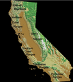 California Mountain Ranges.png 1,364 × 1,530; 1.9 MB
-
 Colorado - DPLA - 125b9e00d1bb40b783e7ed4db08b9332.jpg 8,999 × 6,566; 19.93 MB
-
 Klamath Mountains map.gif 515 × 684; 33 KB
-
 Madison & Spanish Peaks.JPG 629 × 335; 89 KB
-
 MarlboroMountainsLabeled.png 727 × 842; 876 KB
-
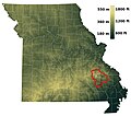 MO relief St Francois Mtns.jpg 1,810 × 1,606; 340 KB
-
 Ouachita Mountains topographic v1 locator.svg 338 × 218; 579 KB
-
 Ouachita Mountains topographic v1.svg 1,535 × 721; 10.42 MB
-
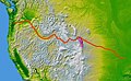 Wpdms nasa topo oregon trail1.jpg 500 × 310; 46 KB
-
 Wrangell Mountains.jpg 512 × 379; 68 KB


