Category:Maps of Scarborough, Ontario
Jump to navigation
Jump to search
Wikimedia category | |||||
| Upload media | |||||
| Instance of | |||||
|---|---|---|---|---|---|
| Category combines topics | |||||
| Scarborough | |||||
district in Toronto, Ontario, Canada    | |||||
| Instance of |
| ||||
| Part of | |||||
| Location | |||||
| Inception |
| ||||
| Population |
| ||||
| Area |
| ||||
 | |||||
Media in category "Maps of Scarborough, Ontario"
The following 17 files are in this category, out of 17 total.
-
 Scarborough Centre Elections Canada map 35094 (2015 boundaries).gif 800 × 593; 228 KB
-
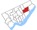
 Scarborough Centre, 1976.png 681 × 602; 76 KB
-
 Scarborough Centre, 1988.png 700 × 604; 79 KB
-
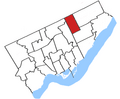
 Scarborough Centre, 96.png 400 × 329; 45 KB
-
 Scarborough locator.png 1,500 × 1,115; 575 KB
-
 Scarborough map.png 1,000 × 1,150; 435 KB
-
 Scarborough North Elections Canada map 35096 (2015 boundaries).gif 800 × 593; 208 KB
-
 Scarborough Southwest Elections Canada map 35098 (2015 boundaries).gif 800 × 593; 164 KB
-
 Scarborough Southwest, 96.png 400 × 329; 45 KB
-
 Scarborough-Agincourt Elections Canada map 35093 (2015 boundaries).gif 800 × 1,078; 259 KB
-
 Scarborough-Guildwood Elections Canada map 35095 (2015 boundaries).gif 800 × 1,079; 258 KB
-
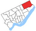
 Scarborough-Rouge Park Elections Canada map 35097 (boundaries).gif 800 × 1,078; 305 KB
-
 Scarborough—Agincourt, 1988.png 700 × 604; 79 KB
-
 Scarborough—Agincourt, 96.png 400 × 329; 45 KB
-
 Scarborough—Rouge River, 1987.png 700 × 604; 79 KB
-
 Scarborough—Rouge River, 96.png 400 × 329; 45 KB
-
 Toronto Scarborough location.png 378 × 379; 13 KB
.gif)


.gif)
.gif)

.gif)
.gif)
.gif)


