Category:Maps of North Yorkshire
Jump to navigation
Jump to search
Wikimedia category | |||||
| Upload media | |||||
| Instance of | |||||
|---|---|---|---|---|---|
| Category combines topics | |||||
| North Yorkshire | |||||
ceremonial county in England, UK      | |||||
| Instance of |
| ||||
| Part of | |||||
| Location |
| ||||
| Capital | |||||
| Inception |
| ||||
| Population |
| ||||
| Area |
| ||||
| Different from | |||||
| official website | |||||
 | |||||
Subcategories
This category has the following 9 subcategories, out of 9 total.
Media in category "Maps of North Yorkshire"
The following 43 files are in this category, out of 43 total.
-

-
 Admiralty Chart No 1200 Hartlepool to Flamborough Head, Published 1968.jpg 16,378 × 11,276; 35.11 MB
-
 BAKER(1863) p24 - Geological Map of North Yorkshire.jpg 2,272 × 1,545; 724 KB
-
 BAKER(1863) p91 - Lithological Map of North Yorkshire.jpg 2,224 × 1,566; 675 KB
-
 Coast 2 coast.svg 677 × 296; 34 KB
-
 Diagram of Haydock's rental properties in Whitby.jpg 1,050 × 983; 504 KB
-
 England Police Forces (North Yorkshire).svg 1,108 × 1,345; 312 KB
-
 EnglandNorthYorkshire.png 200 × 247; 22 KB
-
 EnglandNorthYorkshireFireService.png 200 × 247; 23 KB
-
 EnglandPoliceNorthYorkshire.png 2,165 × 2,670; 87 KB
-
 Ingleby Barwick Plan (crop).png 770 × 803; 84 KB
-
 Ingleby Barwick Plan.svg 744 × 1,052; 323 KB
-
 N-York.svg 1,129 × 1,385; 107 KB
-
 North Yorkshire Ceremonial Numbered.png 200 × 153; 5 KB
-
 North Yorkshire Districts Limburgish.png 2,000 × 1,455; 1.22 MB
-
 North Yorkshire numbered districts (1974-2023).svg 1,425 × 1,037; 827 KB
-
 North Yorkshire numbered districts 2023.svg 1,425 × 1,037; 663 KB
-
 North Yorkshire outline map with UK.png 800 × 558; 359 KB
-
 North Yorkshire UK district map 2010 (blank).svg 1,425 × 1,037; 1.26 MB
-
 North Yorkshire UK district map 2023 (blank).svg 1,425 × 1,037; 1.11 MB
-
 North Yorkshire UK electoral division map (blank).svg 1,425 × 1,037; 1.97 MB
-
 North Yorkshire UK location map (1974-2023).svg 1,425 × 1,037; 3.22 MB
-
 North Yorkshire UK location map (2023).svg 1,425 × 1,037; 2.88 MB
-
 North Yorkshire UK locator map 2010.svg 1,108 × 1,345; 302 KB
-
 North Yorkshire UK relief location map.jpg 1,999 × 1,455; 466 KB
-
 North Yorkshire UK ward map (blank).svg 1,425 × 1,037; 2.67 MB
-
 NorthYorkshire2003Option1.png 800 × 558; 370 KB
-
 NorthYorkshire2003Option2a.png 800 × 558; 364 KB
-
 NorthYorkshire2003Option2b.png 800 × 558; 362 KB
-
 NorthYorkshire2003Option3.png 800 × 558; 357 KB
-
 NorthYorkshire2021Option2.png 800 × 558; 367 KB
-
 NorthYorkshireNumbered.png 200 × 138; 14 KB
-
 Ordnance Survey 1-250000 - NY.jpg 4,000 × 4,000; 8.08 MB
-
 Ordnance Survey 1-250000 - NZ.jpg 4,000 × 4,000; 5.22 MB
-
 Ordnance Survey 1-250000 - SD.jpg 4,000 × 4,000; 7.12 MB
-
 Ordnance Survey 1-250000 - SE.jpg 4,000 × 4,000; 8.57 MB
-
 Ordnance Survey 1-250000 - TA.jpg 4,000 × 4,000; 2.3 MB
-
 Ordnance Survey Half-Inch Sheet 9 Harrogate Leeds and Bradford, Published 1912.jpg 12,036 × 8,423; 13.18 MB
-
 Ordnance Survey One-Inch Sheet 97 York, Published 1947.jpg 10,949 × 12,768; 14.95 MB
-
 Ordnance Survey One-Inch Sheet 97 York, Published 1960.jpg 8,248 × 9,876; 10 MB
-
 Ordnance Survey Sheet NZ 10 Richmond Yorkshire, Published 1952.jpg 7,325 × 7,508; 17.01 MB
-
 Six inch map 1854 - Brimham Rocks.jpg 1,080 × 605; 233 KB
-
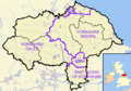
 Yorkshire Dales National Park.png 800 × 558; 379 KB
.jpg)

_p24_-_Geological_Map_of_North_Yorkshire.jpg)
_p91_-_Lithological_Map_of_North_Yorkshire.jpg)


.svg)


.png)


.svg)


.svg)
.svg)


.svg)
.svg)
.svg)
.svg)