Category:Maps of Jamestown, Virginia
Jump to navigation
Jump to search
Media in category "Maps of Jamestown, Virginia"
The following 31 files are in this category, out of 31 total.
-
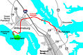
 1646linemap.jpg 300 × 250; 19 KB
-

-

-
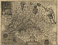 Capt John Smith's map of Virginia 1624.jpg 2,520 × 1,944; 1.02 MB
-
-

-

-

-

-

-

-

-

-

-
 Historic Triangle Virginia.jpg 2,923 × 1,944; 526 KB
-
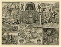 Illustration from John Smith's The Generall Historie of Virginia.jpg 750 × 582; 201 KB
-
 Jamestown BAH.jpg 220 × 218; 9 KB
-
 Jamestown Island (1958 base map).png 3,189 × 2,457; 1.92 MB
-

-

-
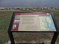
 JamestownMarkerA.jpg 929 × 1,202; 75 KB
-
 Jamestownzuniga.jpg 537 × 600; 69 KB
-
 Jordan Point Native American Settlement from John Smith's Map.jpg 396 × 549; 102 KB
-
 Location of jamestown virginia.jpg 1,284 × 1,104; 1,016 KB
-
 Map showing location of Jamestown and Roanoke Island Colonies.PNG 600 × 400; 119 KB
-
 Norfolk and Portsmouth Traction Company's lines are shown in red (11840196525).jpg 1,524 × 2,000; 3.46 MB
-
 Vingboons - Caert van de rivier powhatan.jpg 800 × 554; 136 KB
-
 Virginia map 1606.jpg 3,500 × 2,709; 6.05 MB
-
 Zuniga Map.jpg 456 × 600; 38 KB
-
 Zuniga map.jpg 803 × 521; 299 KB
-
 Zúñiga Map by Ashe 1908.jpg 1,634 × 1,926; 1.12 MB

.jpg)
.jpg)

.jpg)
.jpg)
.jpg)
.jpg)
.jpg)
.jpg)
.jpg)
.jpg)
.jpg)
.jpg)


.png)
.png)


.jpg)


