Category:Maps of Hastings
Jump to navigation
Jump to search
Wikimedia category | |||||
| Upload media | |||||
| Instance of | |||||
|---|---|---|---|---|---|
| Category combines topics | |||||
| Hastings | |||||
town in East Sussex, on the south coast of England   | |||||
| Instance of | |||||
| Location | Hastings, East Sussex, South East England, England | ||||
| Population |
| ||||
| Area |
| ||||
| Different from | |||||
| official website | |||||
 | |||||
Media in category "Maps of Hastings"
The following 21 files are in this category, out of 21 total.
-
 2022 Hastings Borough Council election.svg 2,980 × 1,540; 711 KB
-

-
 Admiralty Chart No 536 Beachy Head to Dungeness, Published 1967.jpg 16,414 × 11,300; 31.73 MB
-
 Albion Street, Halton, Hastings. (15445017452).jpg 2,601 × 2,195; 932 KB
-
 EastSussexHastings.png 200 × 130; 9 KB
-
 Hastings East Sussex UK district map.svg 1,425 × 928; 411 KB
-
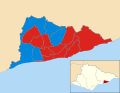
 Hastings UK local election 2002 map.svg 1,425 × 1,104; 204 KB
-
 Hastings UK local election 2004 map.svg 1,425 × 1,104; 203 KB
-
 Hastings UK local election 2006 map.svg 1,425 × 1,104; 203 KB
-
 Hastings UK local election 2008 map.svg 1,425 × 1,104; 203 KB
-
 Hastings UK local election 2010 map.svg 1,425 × 1,104; 203 KB
-
 Hastings UK local election 2012 map.svg 1,425 × 1,104; 205 KB
-
 Hastings UK local election 2014 map.svg 1,425 × 1,104; 205 KB
-
 Hastings UK local election 2021 map.svg 1,425 × 1,104; 205 KB
-
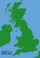
 Hastings UK locator map.svg 1,425 × 928; 787 KB
-
 Hastings UK ward map 2010 (blank).svg 1,425 × 1,104; 203 KB
-
 Hastings UK ward map 2024.svg 1,425 × 1,104; 205 KB
-
 Location Hastings East Sussex.png 1,802 × 2,589; 189 KB
-
 Ordnance Survey Drawings - Hastings (OSD 103).jpg 4,202 × 5,411; 3.58 MB
-
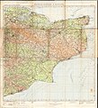 Ordnance Survey Half-inch Sheet 40 Chatham Margate & Hastings, Published 1927.jpg 10,227 × 11,226; 13.78 MB
-
 Ordnance Survey One-Inch Sheet 135 Hastings, Published 1921.jpg 12,015 × 9,047; 39.44 MB

%27_(11006824843).jpg)

.jpg)


.jpg)


.svg)