Category:Maps of Dublin
Jump to navigation
Jump to search
Wikimedia category | |||||
| Upload media | |||||
| Instance of | |||||
|---|---|---|---|---|---|
| Category combines topics | |||||
| Dublin | |||||
capital and largest city of Ireland         | |||||
| Instance of |
| ||||
| Location |
| ||||
| Located in or next to body of water | |||||
| Legislative body |
| ||||
| Executive body |
| ||||
| Head of government |
| ||||
| Present in work |
| ||||
| Inception |
| ||||
| Significant event |
| ||||
| Population |
| ||||
| Area |
| ||||
| Elevation above sea level |
| ||||
| Different from | |||||
| official website | |||||
 | |||||
Subcategories
This category has the following 6 subcategories, out of 6 total.
E
- Election maps of Dublin (5 F)
M
- Maps of the history of Dublin (12 F)
O
- OpenStreetMap maps of Dublin (14 F)
P
T
- Tram maps of Dublin (15 F)
Pages in category "Maps of Dublin"
This category contains only the following page.
Media in category "Maps of Dublin"
The following 38 files are in this category, out of 38 total.
-

-

-
 1606 map.jpg 1,525 × 907; 627 KB
-
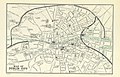
 1797 map of Dublin, Ireland.jpg 1,024 × 684; 262 KB
-
 19 of 'Dignam's Dublin Guide. With a handy map, etc' (11209516723).jpg 3,401 × 2,690; 2.11 MB
-
-

-
 479 of 'Die Erde. Eine allgemeine Erd- und Länderkunde, etc' (11238152685).jpg 1,685 × 1,320; 613 KB
-
 Abbey Street Luas and pavement layout.png 4,234 × 2,605; 969 KB
-
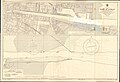
 Admiralty Chart No 1447 Port of Dublin, Published 1951 (composite).jpg 30,296 × 6,739; 59.75 MB
-
 Admiralty Chart No 1447 Port of Dublin, Published 1951.jpg 16,267 × 11,114; 61.56 MB
-
 Admiralty Chart No 1825a The Irish Sea, Published 1925.jpg 16,412 × 15,521; 22.26 MB
-

-
 Cornelscourt town, Dún Laoghaire-Rathdown.jpg 1,412 × 794; 252 KB
-

-
-
 DUB map.png 300 × 300; 26 KB
-
 Dublin City Boundaries 2020.png 2,552 × 2,480; 484 KB
-
 Dublin Exhibition Palace and Winter Garden (now Iveagh Gardens).png 1,574 × 1,336; 287 KB
-
 Dublin printable tourist attractions map.jpg 2,105 × 1,488; 1.29 MB
-
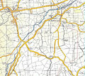
 DublinM50.png 640 × 534; 70 KB
-
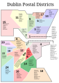 DublinPC.svg 744 × 1,052; 52 KB
-
 Elm Park Stream, much visible in 1958, Dublin, Ireland.jpg 863 × 473; 246 KB
-
 Greater Dublin Area location map.svg 370 × 579; 872 KB
-
 Greater Dublin Area.png 394 × 530; 8 KB
-
 Ireland Dublin location map.svg 1,372 × 975; 330 KB
-
 Ireland900.svg 633 × 825; 1,009 KB
-
 Island of Ireland location map Greater Dublin Area.svg 1,450 × 1,807; 858 KB
-

-
 Map molesworth street.jpg 590 × 361; 53 KB
-
 Map of Casino Gardens.jpg 2,448 × 3,264; 2.95 MB
-
 Map of the quays of Dublin city Ireland 2023 linear.svg 4,001 × 391; 103 KB
-
 Map of the quays of Dublin city Ireland 2023 stacked.svg 1,013 × 1,694; 183 KB
-

-
 Platform For Change Full Map of Projects 2001.jpg 769 × 608; 83 KB
-

-
 Stephensgreenmap.gif 277 × 203; 4 KB
-
 Stephensgreenmap.png 277 × 203; 7 KB
.jpg)
.jpg)


.jpg)
.jpg)
.jpg)
.jpg)


.png)


_(14577209117).jpg)


.jpg)


.jpg)