Category:Maps of 10th-century India
Jump to navigation
Jump to search
Countries of Asia: India
Media in category "Maps of 10th-century India"
The following 6 files are in this category, out of 6 total.
-
 Aditya territories.png 2,745 × 1,952; 1.26 MB
-
 Hindu Shahi Dynasty.png 317 × 267; 246 KB
-
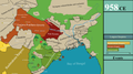 Map of Bengal in 958 CE.png 8,000 × 4,500; 2.78 MB
-
 Parantaka territories late.png 430 × 393; 19 KB
-
 Parantaka territories.png 430 × 339; 24 KB
-
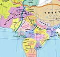 Держава Томарів та Індія в X столітті..jpg 462 × 434; 78 KB


