Category:Maps and diagrams of the Peak District
Jump to navigation
Jump to search
Media in category "Maps and diagrams of the Peak District"
The following 18 files are in this category, out of 18 total.
-
 Geology Map of the Peak District.png 1,019 × 1,362; 121 KB
-
 Geology of Curbar Edge.jpg 460 × 220; 17 KB
-
 Geologyofglossop.svg 321 × 167; 137 KB
-
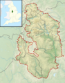
 Map of Derbyshire boundaries plus Peak District.jpg 1,803 × 2,309; 2.35 MB
-
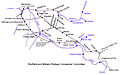 Midland to Manchester.jpg 800 × 502; 71 KB
-
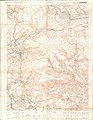 Ordnance Survey Outdoor Leisure Map of the Dark Peak, Published 1972.jpg 14,334 × 18,498; 76.32 MB
-
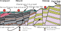
 Peak District Cross Section.gif 563 × 269; 14 KB
-
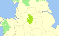
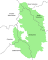 Peak District National Park - Counties Map.png 799 × 1,002; 60 KB
-
 Peak District National Park map.svg 1,022 × 1,305; 1.2 MB
-
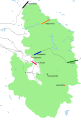 Peak District National Park tunnels.svg 836 × 1,240; 337 KB
-
 Peak District National Park UK location map.svg 1,022 × 1,305; 1.41 MB
-
 Peak District National Park UK relief location map.png 2,000 × 2,557; 3.32 MB
-
 Peak District National Park.svg 1,173 × 720; 169 KB
-
 Reservoirs of the Peak District.png 675 × 862; 58 KB
-
 Rivers of the Peak District.png 799 × 1,069; 72 KB
-
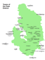 Towns of the Peak District.png 794 × 1,067; 78 KB
-
 Tunnels in the Peak District National Park.svg 836 × 1,240; 610 KB
-
 Wetton sketch plan.gif 1,480 × 970; 56 KB


