Category:Loys Station Covered Bridge
Jump to navigation
Jump to search
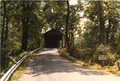
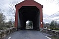
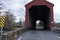
English: Loys Station Covered Bridge near Thurmont, Maryland, USA
|
This is a category about a place or building that is listed on the National Register of Historic Places in the United States of America. Its reference number is 78003175. |
| Object location | | View all coordinates using: OpenStreetMap |
|---|
 | |||||
| Upload media | |||||
| Instance of | |||||
|---|---|---|---|---|---|
| Location | Frederick County, Maryland | ||||
| Heritage designation |
| ||||
| Inception |
| ||||
| Significant event |
| ||||
 | |||||
Media in category "Loys Station Covered Bridge"
The following 30 files are in this category, out of 30 total.
-
 Approach Loys Station 001.png 3,568 × 2,384; 8.96 MB
-
 Approach Loys Station 002.png 3,552 × 2,392; 9.66 MB
-
 Bridge, Thurmont, Maryland LCCN2011631711.tif 5,362 × 6,901; 211.76 MB
-
 Loy's bridge, (Frederick County,) Maryland LCCN2011630171.tif 3,466 × 4,404; 87.37 MB
-
 Loy's Station Covered Bridge, Thurmont, MD (8628867340).jpg 1,110 × 798; 557 KB
-
 Loys Station Bridge - panoramio (1).jpg 1,600 × 1,200; 283 KB
-
 Loys Station Bridge - panoramio (2).jpg 1,600 × 1,200; 990 KB
-
 Loys Station Bridge - panoramio.jpg 1,200 × 1,600; 714 KB
-
 Loys Station Bridge 2009 - panoramio.jpg 1,600 × 1,200; 601 KB
-
 Loys Station Bridge circa 1971 - panoramio.jpg 1,836 × 1,832; 386 KB
-
 Loys Station Covered Bridge 04.JPG 4,272 × 2,848; 4.66 MB
-
 Loys Station Covered Bridge 05.JPG 4,272 × 2,848; 1.8 MB
-
 Loys Station Covered Bridge 06.JPG 4,272 × 2,848; 3.35 MB
-
 Loys Station Covered Bridge 07.JPG 4,272 × 2,848; 3.64 MB
-
 Loys Station Covered Bridge 08.JPG 2,848 × 4,272; 3.67 MB
-
 Loys Station Covered Bridge 09.JPG 2,848 × 4,272; 3.12 MB
-
 Loys Station Covered Bridge 10.JPG 2,848 × 4,272; 4.38 MB
-
 Loys Station Covered Bridge 11.JPG 4,272 × 2,848; 3.74 MB
-
 Loys Station Covered Bridge 12.JPG 4,272 × 2,848; 3.39 MB
-
 Loys Station Covered Bridge 13.JPG 4,272 × 2,848; 4.78 MB
-
 Loys Station covered bridge 13523v.jpg 810 × 1,024; 466 KB
-
 Loys Station covered bridge 13532v.jpg 1,024 × 798; 560 KB
-
 Loys Station Covered Bridge 16.JPG 4,272 × 2,848; 6.83 MB
-
 Loys Station Covered Bridge 17.JPG 2,848 × 4,272; 4.04 MB
-
 LOYS STATION COVERED BRIDGE, FREDERICK COUNTY, MD.jpg 5,277 × 3,531; 2.03 MB
-
 Loys Station covered bridge, Thurmont, Maryland, built in 1900 LCCN2011631717.tif 5,462 × 6,901; 215.71 MB
-
 Loys Station covered bridge, Thurmont, Maryland, built in 1900 LCCN2011631726.tif 6,971 × 5,432; 216.7 MB
-
 Loys Station Covered Bridge.jpg 3,888 × 2,592; 3.84 MB
-
 Loys Station Field Condition in the 1980s (2).png 2,967 × 6,496; 19.64 MB
-
 Loys Station Field Condition in the 1980s.png 2,967 × 6,432; 20.74 MB


.jpg)
.jpg)
.jpg)


.png)

Categories:
- 1860s bridges in Maryland
- Covered bridges in Maryland
- National Register of Historic Places in Frederick County, Maryland
- Bridges on the National Register of Historic Places in Maryland
- Built in Maryland in 1860
- Bridges in the United States completed in 1860
- Loys Station Park
- Roads in Frederick County, Maryland
- Owens Creek (Monocacy River)
- Red covered bridges in the United States