Category:Locator maps of districts of Austria
Jump to navigation
Jump to search
Countries of Europe: Albania · Austria · Azerbaijan‡ · Czech Republic · Finland · Hungary · Kazakhstan‡ · Portugal‡ · Serbia · Slovakia · United Kingdom
Limited recognition: Kosovo · South Ossetia‡
‡: partly located in Europe
Limited recognition: Kosovo · South Ossetia‡
‡: partly located in Europe
Deutsch: Karten der Bezirke Österreichs (80) zuzüglich 15 Statutarstädte und 1 Expositur, siehe Liste der Bezirke und Statutarstädte in Österreich
sortiert nach Namen (Bitte Umlaute durch einfachen Vokal ersetzen, ß durch ss, „Sankt“ unter «St.»)
sortiert nach Namen (Bitte Umlaute durch einfachen Vokal ersetzen, ß durch ss, „Sankt“ unter «St.»)
English: Maps of Austrian districts, including 15 statuary cities (Statutarstädte) and 1 Expositur, sorted by (german!) name
ToDo:
- some left in Category:Maps of Austria
PLEASE DO NOT SPLIT INTO STATES! see Category:Maps of districts of Austria for assorted
Subcategories
This category has only the following subcategory.
O
Media in category "Locator maps of districts of Austria"
The following 28 files are in this category, out of 28 total.
-
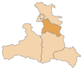
 Karte Aut Stmk ohne.png 1,000 × 700; 150 KB
-
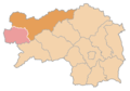
 Karte Aut Stmk BM-2013.png 1,000 × 700; 98 KB
-
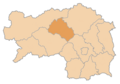
 Karte Aut Stmk DL.png 1,000 × 700; 98 KB
-
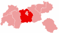
 Karte Aut Stmk GU.png 1,000 × 700; 98 KB
-
 Karte A Sbg HA.svg 1,050 × 890; 11 KB
-
 Salzburg Tennengau.png 300 × 255; 2 KB
-
 Karte Aut Ooe L.png 300 × 265; 5 KB
-
 Karte Aut Stmk G.png 1,000 × 700; 97 KB
-
 Karte Aut Stmk HF.png 1,000 × 700; 98 KB
-
 Karte Aut Stmk LI.png 1,000 × 700; 98 KB
-
 Karte Aut Stmk LN.png 1,000 × 700; 98 KB
-
 Karte Aut Stmk MU.png 1,000 × 700; 98 KB
-
 Karte Aut Stmk VO.png 1,000 × 700; 98 KB
-
 Karte Aut Stmk WZ.png 1,000 × 700; 98 KB
-
 Karte-tirol-I.png 300 × 167; 9 KB
-
 Karte-tirol-IL.png 300 × 167; 3 KB
-
 Karte-tirol-IM.png 300 × 167; 3 KB
-
 Karte-tirol-KB.png 300 × 167; 4 KB
-
 Karte-tirol-KU.png 300 × 167; 4 KB
-
 Karte-tirol-RE.png 300 × 167; 3 KB
-
 Karte-tirol-SZ.png 300 × 167; 4 KB
-
 Karte-tirol.png 300 × 167; 3 KB
-
 Karte A Tirol LA.svg 1,050 × 600; 16 KB
-
 Karte Aut Stmk LB.png 1,000 × 700; 97 KB
-
 Karte Aut Stmk GB.png 1,000 × 700; 100 KB
-
 Karte Aut Stmk MT.PNG 1,000 × 700; 98 KB
-
 Pongau, Österreich.svg 711 × 399; 54 KB
-
 Karte A Sbg SL.svg 1,050 × 890; 11 KB


