Category:Locator maps of countries of Africa (gray scheme)
Jump to navigation
Jump to search
Subcategories
This category has the following 4 subcategories, out of 4 total.
Media in category "Locator maps of countries of Africa (gray scheme)"
The following 26 files are in this category, out of 26 total.
-
 2012 Africa Cup of Nations qualification.png 2,000 × 2,000; 303 KB
-
 African Economic Community membership map.png 323 × 360; 12 KB
-
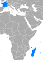
 Afrique latine1.png 360 × 392; 15 KB
-
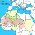
 AQIM operational map.svg 468 × 344; 132 KB
-
 Borderless countries.PNG 1,357 × 628; 29 KB
-
 Borderless countries.svg 2,560 × 1,314; 1.05 MB
-
 Borderless states.PNG 1,427 × 628; 54 KB
-
 LocationBritish overseas territories.png 1,248 × 628; 40 KB
-
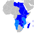 COMESA Members.PNG 341 × 341; 10 KB
-
 Egypt Locator.png 1,160 × 1,056; 64 KB
-
 GSPC map.png 350 × 350; 15 KB
-
 Indian Ocean Commission member states.png 269 × 374; 10 KB
-
 Island nations.png 1,427 × 628; 56 KB
-
 Location of Sudan.png 332 × 355; 11 KB
-
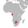
 Locator Zambia Zimbabwe SouthAfrica.png 250 × 130; 8 KB
-

-
 Morocco Locator.png 1,160 × 1,056; 64 KB
-
 Namibia Botswana Locator.png 2,754 × 1,397; 288 KB
-
 Nigeria South Africa locator.png 367 × 424; 38 KB
-

-
 Sh location atlantik3.png 729 × 490; 87 KB
-
 TransAfrica.png 1,276 × 833; 36 KB
-
 Tunisia Locator.png 1,160 × 1,056; 64 KB
-
 WOSM-WAGGGSAfricaMap-World.png 757 × 785; 92 KB
-
 África noroccidental.png 346 × 365; 7 KB
-
 المغرب العربي.png 353 × 375; 10 KB


