Category:Lautertal (Upper Franconia)
Jump to navigation
Jump to search
municipality in Bavaria, Germany  Евангелическая кирха в Лаутертале    | |||||
| Upload media | |||||
| Instance of |
| ||||
|---|---|---|---|---|---|
| Part of |
| ||||
| Location | Coburg, Upper Franconia, Bavaria, Germany | ||||
| Head of government |
| ||||
| Population |
| ||||
| Area |
| ||||
| Elevation above sea level |
| ||||
| Different from | |||||
| official website | |||||
 | |||||
Subcategories
This category has the following 5 subcategories, out of 5 total.
Media in category "Lautertal (Upper Franconia)"
The following 9 files are in this category, out of 9 total.
-
 96486 Lautertal, Germany - panoramio.jpg 1,944 × 2,592; 1.36 MB
-
 DEU Lautertal COA.svg 512 × 559; 29 KB
-
 Digitales Orthofoto von Lautertal (Bayerische Vermessungsverwaltung).tif 20,000 × 32,500; 951.63 MB
-
 Lautertal in CO.png 472 × 463; 14 KB
-
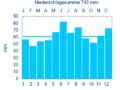 LAUTERTAL OBERLAU AWST nieder.png 480 × 360; 5 KB
-
 LAUTERTAL OBERLAU AWST nieder.svg 512 × 427; 21 KB
-
 Lautertal, CO - Rottenbach v NW.jpg 4,608 × 2,592; 693 KB
-
 DEU Lautertal Oberfr. COA.svg 442 × 476; 8 KB
-
 Wappen von Lautertal.png 220 × 233; 26 KB


