Category:Koepelkerk (Renswoude)
Jump to navigation
Jump to search
| Object location | | View all coordinates using: OpenStreetMap |
|---|
church building in Renswoude, Netherlands  | |||||
| Upload media | |||||
| Instance of | |||||
|---|---|---|---|---|---|
| Made from material | |||||
| Location | Renswoude, Utrecht, Netherlands | ||||
| Street address |
| ||||
| Located on street |
| ||||
| Architectural style | |||||
| Architect | |||||
| Heritage designation |
| ||||
| Inception |
| ||||
| Significant event |
| ||||
 | |||||
|
This is a category about rijksmonument number 32450
|
| Address |
|
Media in category "Koepelkerk (Renswoude)"
The following 58 files are in this category, out of 58 total.
-
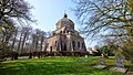
 3927 Renswoude, Netherlands - panoramio (24).jpg 2,048 × 1,155; 625 KB
-
 3927 Renswoude, Netherlands - panoramio (25).jpg 1,155 × 2,048; 532 KB
-
 3927 Renswoude, Netherlands - panoramio (26).jpg 2,048 × 1,155; 909 KB
-
 3927 Renswoude, Netherlands - panoramio (28).jpg 2,048 × 1,155; 837 KB
-
 3927 Renswoude, Netherlands - panoramio (29).jpg 2,048 × 1,155; 595 KB
-
 3927 Renswoude, Netherlands - panoramio (34).jpg 1,155 × 2,048; 642 KB
-
 3927 Renswoude, Netherlands - panoramio (6).jpg 2,048 × 1,375; 504 KB
-
 Church in Renswoude, designed by Jacob van Campen.JPG 2,592 × 1,944; 1.5 MB
-
 De Hervormde Koepelkerk..JPG 800 × 534; 137 KB
-
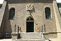 De robuste ingangspartij van de Hervormde kerk in Renswoude..JPG 800 × 534; 269 KB
-
 Exterieur - Renswoude - 20185446 - RCE.jpg 1,200 × 956; 200 KB
-
 Exterieur - Renswoude - 20185447 - RCE.jpg 955 × 1,200; 279 KB
-
 Exterieur naar het noordwesten - Renswoude - 20185420 - RCE.jpg 878 × 1,200; 208 KB
-
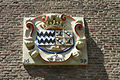 Het wapen van Renwouse aan de Koepelkerk.JPG 800 × 534; 225 KB
-
 HUA-107614-Gezicht op de Nederlands Hervormde kerk te Renswoude.jpg 3,659 × 3,856; 3.27 MB
-
 Interieur - Renswoude - 20185429 - RCE.jpg 972 × 1,200; 184 KB
-
 Interieur - Renswoude - 20185430 - RCE.jpg 1,200 × 959; 186 KB
-
 Interieur - Renswoude - 20185443 - RCE.jpg 960 × 1,200; 154 KB
-
 Interieur - Renswoude - 20185444 - RCE.jpg 773 × 1,200; 133 KB
-
 Interieur - Renswoude - 20185445 - RCE.jpg 960 × 1,200; 138 KB
-
 Interieur koepel - Renswoude - 20185424 - RCE.jpg 905 × 1,200; 165 KB
-
 Interieur naar het noord-westen - Renswoude - 20185423 - RCE.jpg 884 × 1,200; 167 KB
-
 Kerk naar het noord-oosten - Renswoude - 20185422 - RCE.jpg 885 × 1,200; 241 KB
-
 Kerk naar het oosten - Renswoude - 20185421 - RCE.jpg 883 × 1,200; 183 KB
-
 Kerk naar het zuid-westen - Renswoude - 20185419 - RCE.jpg 889 × 1,200; 213 KB
-
 Kerk, nummer 936 - Renswoude - 20185439 - RCE.jpg 1,200 × 810; 204 KB
-
 Koepelbeschildering - Renswoude - 20185432 - RCE.jpg 960 × 1,200; 182 KB
-

-
 Lezenaar - Renswoude - 20185431 - RCE.jpg 1,200 × 958; 213 KB
-
 Offerblok - Renswoude - 20185441 - RCE.jpg 951 × 1,200; 191 KB
-
 Offerblok - Renswoude - 20185442 - RCE.jpg 957 × 1,200; 226 KB
-

-
 Oostgevel, portaal - Renswoude - 20185440 - RCE.jpg 894 × 1,200; 176 KB
-
 Protestant church of Renswoude. It looks like a pyramid - panoramio.jpg 3,648 × 2,432; 2.5 MB
-
 Renswoude Hervormde kerk 1.JPG 2,592 × 1,944; 1.14 MB
-
 Renswoude Hervormde kerk 2.JPG 1,944 × 2,592; 1.3 MB
-
 Renswoude Hervormde kerk 3.JPG 2,592 × 1,944; 1.14 MB
-
 Renswoude Koepelkerk Info Restauratie 1958.jpg 2,821 × 4,584; 4.12 MB
-
 Renswoude Koepelkerk Koepel.jpg 4,153 × 3,318; 4.28 MB
-
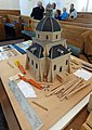 Renswoude Koepelkerk Maquette PvdHoek.jpg 3,144 × 4,432; 4.72 MB
-
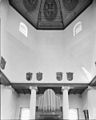
 Renswoude Koepelkerk Orgel.jpg 3,039 × 3,292; 3.56 MB
-
 Renswoude Koepelkerk Predikanten.jpg 2,307 × 3,884; 2.91 MB
-
 Renswoude Koepelkerk Preekstoel.jpg 3,306 × 4,532; 4.72 MB
-
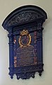
 Renswoude Koepelkerk Rouwbord 1.jpg 2,639 × 4,467; 3.59 MB
-
 Renswoude Koepelkerk Rouwbord 2.jpg 3,147 × 4,533; 4.36 MB
-
 Renswoude Koepelkerk Rouwbord 3.jpg 2,660 × 4,480; 4.16 MB
-
 Renswoude Koepelkerk Rouwbord 4.jpg 2,324 × 4,078; 2.98 MB
-
 Renswoude Koepelkerk Rouwbord 5.jpg 2,108 × 3,413; 2.58 MB
-
 Renswoude, de Nederlands Hervormde kerk RM62450 IMG 4293 2020-04-08 13.52.jpg 3,181 × 4,758; 12.27 MB
-
 Rouwbord - Renswoude - 20185426 - RCE.jpg 978 × 1,200; 265 KB
-
 Rouwbord - Renswoude - 20185427 - RCE.jpg 965 × 1,200; 215 KB
-
 Rouwbord - Renswoude - 20185433 - RCE.jpg 967 × 1,200; 152 KB
-
 Rouwbord - Renswoude - 20185434 - RCE.jpg 959 × 1,200; 222 KB
-
 The church of Renswoude PK-1971-P-7a, PK-T-AW-8.tiff 1,927 × 1,480; 8.19 MB
-
 Wapenschilden - Renswoude - 20185435 - RCE.jpg 1,200 × 969; 169 KB
-
 Wapenschilden - Renswoude - 20185436 - RCE.jpg 1,200 × 962; 157 KB
-
 Wapenschilden - Renswoude - 20185437 - RCE.jpg 1,200 × 968; 171 KB
-
 Wapenschilden - Renswoude - 20185438 - RCE.jpg 1,200 × 946; 148 KB
.jpg)
.jpg)
.jpg)
.jpg)
.jpg)
.jpg)
.jpg)


