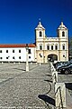
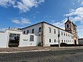
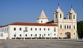
Category:Igreja dos Agostinhos
Jump to navigation
Jump to search
| Object location | | View all coordinates using: OpenStreetMap |
|---|
|
This monument is classified as
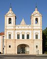
Monumento Nacional .It is indexed in the IGESPAR database ( Instituto de Gestão do Património Arquitectónico e Arqueológico ), under the reference 70207.It is indexed in the SIPA database (Sistema de Informação para o Património Arquitectónico) under the reference 2775. |
church building in Vila Viçosa, Évora District, Portugal  | |||||
| Upload media | |||||
| Instance of | |||||
|---|---|---|---|---|---|
| Location | Conceição, Nossa Senhora da Conceição e São Bartolomeu, Vila Viçosa, Évora, Portugal | ||||
| Heritage designation | |||||
| Religion or worldview | |||||
 | |||||
Media in category "Igreja dos Agostinhos"
The following 26 files are in this category, out of 26 total.
-
 Igreja ao luar (5655096588).jpg 2,857 × 1,899; 1.02 MB
-
 Igreja do Mosteiro de Santo Agostinho, Vila Viçosa, Portugal (3308872899).jpg 926 × 1,390; 169 KB
-
 Igreja do Mosteiro de Santo Agostinho, Vila Viçosa, Portugal (3309701504).jpg 819 × 1,293; 198 KB
-
 Igreja do Mosteiro de Santo Agostinho, Vila Viçosa, Portugal (3309701708).jpg 1,277 × 844; 176 KB
-
 Igreja do Mosteiro de Santo Agostinho, Vila Viçosa, Portugal (3309701784).jpg 1,369 × 931; 194 KB
-
 Igreja dos Agostinhos - Vila Viçosa - Portugal (11311259403).jpg 5,639 × 3,888; 4.15 MB
-
 Igreja dos Agostinhos - Vila Viçosa - Portugal (11713861805).jpg 5,832 × 3,888; 2.5 MB
-
 Igreja dos Agostinhos - Vila Viçosa - Portugal (3319346365).jpg 853 × 1,280; 369 KB
-
 Igreja dos Agostinhos - Vila Viçosa - Portugal (8035664720).jpg 3,725 × 5,697; 6.37 MB
-
 Igreja dos Agostinhos - Vila Viçosa - Portugal (9504131567).jpg 3,839 × 5,757; 4.55 MB
-
 Igreja dos Agostinhos, Vila Viçosa 01.jpg 2,254 × 1,691; 1.36 MB
-
 Padrão and side entrance to Agostinhos Church, Vila Viçosa, Portugal julesvernex2.jpg 2,240 × 2,589; 1.32 MB
-
 Seminário de São José (Seminário Menor de Évora), Vila Viçosa 02.jpg 2,300 × 1,725; 1.22 MB
-
 Vila Viçosa - Igreja dos Agostinhos.jpg 3,872 × 2,592; 3.13 MB
-
 Vila Viçosa - SJ (2).jpg 3,008 × 2,000; 1.5 MB
-
 Vila Viçosa - SJ (24).jpg 2,592 × 3,872; 2.48 MB
-
 Vila Viçosa - SJ (25).jpg 3,872 × 2,592; 2.36 MB
-
 Vila Viçosa - SJ (26).jpg 2,592 × 3,872; 2.59 MB
-
 Vila Viçosa - SJ (27).jpg 3,872 × 2,592; 2.47 MB
-
 Vila Viçosa - SJ (29).jpg 2,592 × 3,872; 2.34 MB
-
 Vila Viçosa - SJ (30).jpg 3,872 × 2,592; 2.48 MB
-
 Vila Viçosa - SJ (4).jpg 3,008 × 2,000; 1.48 MB
-
 Vila Viçosa - SJ (5).jpg 3,008 × 2,000; 981 KB
-
 Vila Viçosa April 2011-3a.jpg 5,572 × 2,540; 2.78 MB
-
 Vila Viçosa September 2013-7a.jpg 4,649 × 2,693; 1.96 MB
-
 Vila Viçosa September 2013-8.jpg 4,590 × 5,720; 14.19 MB
.jpg)
.jpg)
.jpg)
.jpg)
.jpg)
.jpg)
.jpg)
.jpg)
.jpg)
.jpg)


,_Vila_Vi%C3%A7osa_02.jpg)

.jpg)
.jpg)
.jpg)
.jpg)
.jpg)
.jpg)
.jpg)
.jpg)
.jpg)

