Category:Hornisgrindeturm
Jump to navigation
Jump to search
| Object location | | View all coordinates using: OpenStreetMap |
|---|
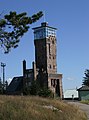
observation tower on Hornisgrinde mountain in the Black Forest  | |||||
| Upload media | |||||
| Instance of | |||||
|---|---|---|---|---|---|
| Named after | |||||
| Made from material | |||||
| Location | Seebach, Kappelrodeck GVV, Ortenau, Freiburg Government Region, Baden-Württemberg, Germany | ||||
| Commissioned by | |||||
| Heritage designation | |||||
| Height |
| ||||
 | |||||
Media in category "Hornisgrindeturm"
The following 33 files are in this category, out of 33 total.
-
 2020 08 20 Hornisgrinde Schwarzwald 01.jpg 3,024 × 4,032; 7.25 MB
-
 Aussichtsturm Hornisgrinde.jpg 1,536 × 2,048; 562 KB
-
 Hornisgrinde, der Hornisgrindeturm.jpg 2,496 × 4,011; 2.05 MB
-
 Hornisgrinde- Observation tower - Inscription.jpg 5,492 × 3,637; 18.63 MB
-
 Hornisgrinde-Aussichtsturm-02-2013-gje.jpg 5,184 × 2,749; 3.62 MB
-
 Hornisgrinde-Aussichtsturm-04-2007-gje.jpg 3,072 × 2,048; 2.01 MB
-
 Hornisgrinde-Aussichtsturm-06-2007-gje.jpg 2,048 × 2,769; 1.41 MB
-
 Hornisgrinde-Aussichtsturm-08-2013-gje.jpg 3,456 × 3,940; 3.26 MB
-
 Hornisgrinde-Aussichtsturm-10-2009-gje.jpg 3,072 × 2,048; 2.04 MB
-
 Hornisgrinde-Aussichtsturm-12-2009-gje.jpg 3,072 × 2,048; 2.06 MB
-
 Hornisgrinde-Aussichtsturm-14-2009-gje.jpg 3,063 × 1,911; 1.75 MB
-
 Hornisgrinde-Turm1.jpg 2,073 × 1,384; 792 KB
-
 Hornisgrinde-Turm2.jpg 1,911 × 1,276; 692 KB
-
 Hornisgrindeturm (1).jpg 1,728 × 2,304; 1.15 MB
-
 Hornisgrindeturm (2).jpg 2,304 × 1,728; 1.27 MB
-
 Hornisgrindeturm (3).jpg 2,304 × 1,728; 683 KB
-
 Hornisgrindeturm 2011.jpg 1,544 × 2,300; 2.6 MB
-
 Hornisgrindeturm 2020-03-14 01.jpg 8,368 × 5,584; 15.8 MB
-
 Hornisgrindeturm 2020-03-14 02.jpg 8,368 × 5,584; 14.5 MB
-
 Hornisgrindeturm 6386.jpg 5,504 × 8,256; 25.95 MB
-
 Hornisgrindeturm April 2011.JPG 2,950 × 1,992; 3.23 MB
-
 Hornisgrindeturm copyright Tourist-Info. Seebach.jpg 3,024 × 4,032; 2.31 MB
-
 Hornisgrindeturm from Mummelsee 2020-03-14 01.jpg 8,368 × 5,584; 17.35 MB
-
 Hornisgrindeturm from Mummelsee 2020-03-14 02.jpg 8,368 × 5,584; 18.13 MB
-
 Hornisgrindeturm-01.jpg 3,240 × 4,320; 4.69 MB
-
 Hornisgrindeturm-02.jpg 4,320 × 3,240; 5.36 MB
-
 Hornisgrindeturm-03-Detail.jpg 4,320 × 3,240; 5.43 MB
-
 Hornisgrindeturm-04-Gedenkstein.jpg 4,320 × 3,240; 5.72 MB
-
 Hornisgrindeturm-05-Tafel.jpg 3,240 × 4,320; 4.65 MB
-
 HornisgrindeturmWinter.JPG 1,536 × 2,048; 1.5 MB
-
 HornisgrindeWinter.JPG 2,019 × 1,135; 631 KB
-
 Landappbw 243138 1818 Hornisgrindeturm Mummelsee.jpg 719 × 1,280; 105 KB
-
 Tower And The Starry Sky (195432691).jpeg 1,280 × 1,920; 675 KB


.jpg)
.jpg)
.jpg)


.jpeg)
Categories:
- Hornisgrinde
- Buildings in Seebach (Baden)
- Observation towers in Ortenaukreis
- Cultural heritage monuments in Seebach (Baden)
- Built in Baden-Württemberg in 1910
- 23-meter-tall buildings in Germany
- Observation towers in the Black Forest
- Stone towers in Baden-Württemberg
- Sandstone buildings in Baden-Württemberg
- Schwarzwaldverein