Category:Hoeve Einrade (Holset)
Jump to navigation
Jump to search
| Object location | | View all coordinates using: OpenStreetMap |
|---|
building in Harles near Vijlen, Netherlands .JPG) | |||||
| Upload media | |||||
| Instance of | |||||
|---|---|---|---|---|---|
| Location | Harles, Vijlen, Vaals, Limburg, Netherlands | ||||
| Street address |
| ||||
| Located on street |
| ||||
| Heritage designation |
| ||||
 | |||||
|
This is a category about rijksmonument number 36660
|
| Address |
|
Media in category "Hoeve Einrade (Holset)"
The following 46 files are in this category, out of 46 total.
-
 20171017 Schatkamer RHCL Maastricht, cijnsrol hof van Einrade, Holset (14e eeuw).jpg 1,977 × 3,869; 2.07 MB
-
 Binnenplaats nr. F 558-8 - Holset - 20464383 - RCE.jpg 1,200 × 900; 92 KB
-
 Einrade op de kadastrale kaart van 1829.jpg 2,325 × 1,517; 795 KB
-
 Einrade.jpg 2,160 × 1,470; 417 KB
-
 Erf en bakhuis nr. F 558-11 - Holset - 20464387 - RCE.jpg 1,200 × 900; 75 KB
-
 Gevel - Holset - 20114048 - RCE.jpg 1,200 × 794; 349 KB
-
 Gevel - Holset - 20114049 - RCE.jpg 1,200 × 819; 346 KB
-
 Gevels binnenplaats nr. F 558-5 - Holset - 20464386 - RCE.jpg 1,200 × 900; 130 KB
-
 Gevels straatzijde foto nr. 50 - Holset - 20464384 - RCE.jpg 1,200 × 900; 172 KB
-
 Hoeve Einrade, achtergevel - Holset - 20114053 - RCE.jpg 1,200 × 788; 247 KB
-
 Hoeve Einrade, gevel van de stal - Holset - 20114057 - RCE.jpg 1,200 × 788; 262 KB
-
 Hoeve Einrade, linker zij- en achtergevel - Holset - 20114052 - RCE.jpg 1,200 × 788; 201 KB
-
 Hoeve Einrade, overzicht - Holset - 20114062 - RCE.jpg 1,200 × 788; 223 KB
-
 Hoeve Einrade, rechter zijgevel - Holset - 20114055 - RCE.jpg 1,200 × 788; 246 KB
-
 Hoeve Einrade, rechter zijgevel- achter - Holset - 20114056 - RCE.jpg 1,200 × 788; 337 KB
-
 Hoeve Einrade, rechter zijgevel- voor - Holset - 20114054 - RCE.jpg 1,200 × 788; 239 KB
-
 Hoeve Einrade, schuur - Holset - 20114058 - RCE.jpg 1,200 × 788; 256 KB
-
 Hoeve Einrade, schuur - Holset - 20114059 - RCE.jpg 1,200 × 788; 199 KB
-
 Hoeve Einrade, voor- en linker zijgevel - Holset - 20114050 - RCE.jpg 1,200 × 788; 284 KB
-
 Hoeve Einrade, voor- en linker zijgevel - Holset - 20114051 - RCE.jpg 1,200 × 789; 278 KB
-
 Holset-Holset 51 (1).JPG 4,000 × 3,000; 4.87 MB
-
 Holset-Holset 51 (2).JPG 4,000 × 3,000; 5.04 MB
-
 Holset-Holset 51 (3).JPG 4,000 × 3,000; 5.02 MB
-
 Holset-Holset 51 (4).JPG 4,000 × 3,000; 4.59 MB
-
 Holset-Holset 51 (5).JPG 4,000 × 3,000; 4.94 MB
-
 Holset-Holset 51 (6).JPG 4,000 × 3,000; 4.75 MB
-
 Holset-Holset 51 (7).JPG 4,000 × 3,000; 4.76 MB
-
 Holset-Holset 51 (8).JPG 4,000 × 3,000; 4.55 MB
-

-

-
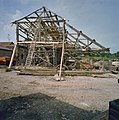
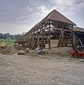
 Schuur tijdens restauratie, dakbedekking is verwijderd - Holset - 20330632 - RCE.jpg 1,188 × 1,200; 324 KB
-
 Schuur tijdens restauratie, dakbedekking is verwijderd - Holset - 20330633 - RCE.jpg 1,188 × 1,200; 336 KB
-
 Schuur tijdens restauratie, dakbedekking is verwijderd - Holset - 20330635 - RCE.jpg 1,189 × 1,200; 346 KB
-
 Schuur tijdens restauratie, dakbedekking is verwijderd - Holset - 20330636 - RCE.jpg 1,192 × 1,200; 334 KB
-
 Schuur tijdens restauratie, dakbedekking is verwijderd - Holset - 20330637 - RCE.jpg 1,186 × 1,200; 302 KB
-
 Schuur tijdens restauratie, dakbedekking is verwijderd - Holset - 20330638 - RCE.jpg 1,191 × 1,200; 280 KB
-
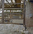
 Schuur tijdens restauratie, detail stenen fundering - Holset - 20330643 - RCE.jpg 1,190 × 1,200; 321 KB
-
 Schuur tijdens restauratie, detail stutbalken - Holset - 20330639 - RCE.jpg 1,195 × 1,200; 314 KB
-
 Schuur tijdens restauratie, detail vakwerk - Holset - 20330644 - RCE.jpg 1,194 × 1,200; 302 KB
-
 Schuur tijdens restauratie, detail vakwerk - Holset - 20330645 - RCE.jpg 1,183 × 1,200; 338 KB
-
 Schuur tijdens restauratie, detail vlechtwerk - Holset - 20330642 - RCE.jpg 1,185 × 1,200; 283 KB
-
 Schuur tijdens restauratie, gerestaureerd hout - Holset - 20330641 - RCE.jpg 1,191 × 1,200; 321 KB
-
 Schuur tijdens restauratie, toestand houtwerk - Holset - 20330640 - RCE.jpg 1,193 × 1,200; 310 KB
-

-

-
 Zij- en kopgevel nr. F 558-3 - Holset - 20464385 - RCE.jpg 1,200 × 900; 102 KB
.jpg)


.JPG)
.JPG)
.JPG)
.JPG)
.JPG)
.JPG)
.JPG)


