Category:Hanita
Jump to navigation
Jump to search
human settlement in Israel  | |||||
| Upload media | |||||
| Instance of |
| ||||
|---|---|---|---|---|---|
| Location | Mateh Asher Regional Council, Acre Subdistrict, Northern District, Israel | ||||
| Inception |
| ||||
| Population |
| ||||
| Elevation above sea level |
| ||||
| official website | |||||
 | |||||
Subcategories
This category has the following 4 subcategories, out of 4 total.
H
- Hanita Museum (44 F)
Media in category "Hanita"
The following 32 files are in this category, out of 32 total.
-

-

-
 Cedar tree in Kibbutz Hanita.JPG 4,608 × 3,456; 5.1 MB
-
 Hebrew alphabet by KKL stamps of places in Israel.png 1,199 × 365; 495 KB
-
 IHM ruins 8.jpeg 1,600 × 1,200; 775 KB
-
 IHM ruins 9.jpeg 1,600 × 1,200; 703 KB
-
 PikiWiki Israel 28621 Art of Israel.jpg 1,299 × 1,559; 1.55 MB
-
 PikiWiki Israel 42678 Tower and stockade circle in Kibbutz Hanita.JPG 4,608 × 3,456; 3.88 MB
-
 PikiWiki Israel 42679 Old mulberry tree in Kibbutz Hanita.JPG 4,608 × 3,456; 5.15 MB
-
 PikiWiki Israel 42680 Old mulberry tree in Kibbutz Hanita.JPG 4,608 × 3,456; 4.49 MB
-
 PikiWiki Israel 42681 Old mulberry tree in Kibbutz Hanita.JPG 4,608 × 3,456; 4.74 MB
-
 PikiWiki Israel 53121 the reconstructed armored vehicle at hanita.jpg 3,113 × 1,967; 1.79 MB
-
 PikiWiki Israel 53122 the reconstructed armored vehicle at hanita.jpg 2,240 × 1,680; 1.1 MB
-
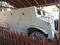 PikiWiki Israel 53123 the reconstructed armored vehicle at hanita.jpg 2,240 × 1,680; 1.26 MB
-
 PikiWiki Israel 53124 the reconstructed armored vehicle at hanita.jpg 2,240 × 1,680; 1.39 MB
-
 PikiWiki Israel 53125 the reconstructed armored vehicle at hanita.jpg 2,240 × 1,680; 1.5 MB
-
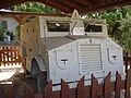 PikiWiki Israel 5462 old armoured vehicle in hanita.jpg 2,048 × 1,536; 687 KB
-
 PikiWiki Israel 61369 kibbutz hanitש tour.jpg 4,999 × 2,893; 1.14 MB
-
 PikiWiki Israel 61370 kibbutz hanitש tour.jpg 5,170 × 2,866; 1.22 MB
-
 PikiWiki Israel 61371 kibbutz hanitש tour.jpg 2,808 × 5,128; 1.97 MB
-
 PikiWiki Israel 61372 kibbutz hanitש tour.jpg 5,132 × 2,485; 1.08 MB
-
 PikiWiki Israel 61373 kibbutz hanitש tour.jpg 4,862 × 1,903; 667 KB
-
 PikiWiki Israel 61384 kibbutz hanitש tour.jpg 4,565 × 2,876; 2 MB
-
 PikiWiki Israel 75017 the tower in kibbutz hanita.jpg 4,000 × 6,000; 3.91 MB
-
 PikiWiki Israel 75018 kibbutz hanita wall and tower.jpg 4,000 × 6,000; 5.35 MB
-
 Sadeh 1938.jpg 2,940 × 1,984; 4.66 MB
-
 Water tower hanita.jpg 1,840 × 3,264; 1,005 KB
-
 בול קק"ל - חניתה-JNF016891.jpeg 398 × 580; 52 KB
-
 בולי קק"ל.-JNF045259.jpeg 490 × 322; 39 KB
-
 יעקב סלומון ההגנה העלייה לחניתה 1938 Jacob (Eugene, Jean) Salomon.png 751 × 1,069; 1.83 MB
-
 יעקב סלומון העלייה לחניתה 1938 Jacob (Eugene, Jean) Salomon Kibbutz Hanita.png 699 × 1,025; 1.8 MB
-
 ירושלים - בולי הקק"ל, חניתה.-JNF039091.jpeg 448 × 600; 67 KB


_Salomon.png)
_Salomon_Kibbutz_Hanita.png)
