Category:Hampstead, Maryland
Jump to navigation
Jump to search
town in Carroll County in the U.S. state of Maryland   | |||||
| Upload media | |||||
| Instance of | |||||
|---|---|---|---|---|---|
| Location | Carroll County, Maryland | ||||
| Inception |
| ||||
| Population |
| ||||
| Area |
| ||||
| Elevation above sea level |
| ||||
| official website | |||||
 | |||||
Subcategories
This category has the following 3 subcategories, out of 3 total.
J
- JoS. A. Bank Clothiers (14 F)
R
- Roads in Hampstead, Maryland (31 F)
Media in category "Hampstead, Maryland"
The following 8 files are in this category, out of 8 total.
-
 Hampstead Elementary School, Hampstead, Maryland.jpg 3,296 × 2,472; 1.08 MB
-
 Hampstead School 2012-09-29 17-27-36.jpg 3,264 × 1,840; 1.75 MB
-
 Hampstead Town Hall, Hampstead, Maryland.jpg 3,296 × 2,472; 1.01 MB
-
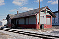 Hampstead Train Station (21591664992).jpg 3,888 × 2,592; 2.01 MB
-
 Hampstead Train Station, roof (21576832616).jpg 3,888 × 2,592; 1.53 MB
-
 Just a Wafer Thin Mint.jpg 5,616 × 3,744; 12.79 MB
-
 North Carroll High School, Hampstead, Maryland.jpg 3,296 × 2,472; 1.13 MB
-
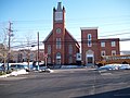 St. John's United Methodist Church (20980240014).jpg 3,296 × 2,472; 1.08 MB


.jpg)
.jpg)


.jpg)