Category:Großsteingrab in den Klöbertannen
Jump to navigation
Jump to search
| Object location | | View all coordinates using: OpenStreetMap |
|---|
dolmen  | |||||
| Upload media | |||||
| Instance of | |||||
|---|---|---|---|---|---|
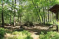
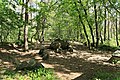
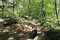
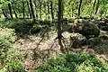
| Location | Werpeloh, Sögel, Emsland, Lower Saxony, Germany | ||||
 | |||||
Media in category "Großsteingrab in den Klöbertannen"
The following 24 files are in this category, out of 24 total.
-
 Großsteingrab Werpeloh II.jpg 2,736 × 3,648; 7.23 MB
-
 NLD Großsteingrab Werpeloh 2 01.jpg 6,000 × 4,000; 3.93 MB
-
 NLD Großsteingrab Werpeloh 2 02.jpg 6,000 × 4,000; 4.68 MB
-
 NLD Großsteingrab Werpeloh 2 03.jpg 6,000 × 4,000; 5 MB
-
 NLD Großsteingrab Werpeloh 2 04.jpg 6,000 × 4,000; 4.68 MB
-
 Werpeloh - Großsteingrab in den Klöbertannen + Steenhus in den Klöbertannen 01 ies.jpg 5,616 × 3,744; 33.86 MB
-
 Werpeloh - Großsteingrab in den Klöbertannen 01 ies.jpg 5,616 × 3,746; 15.97 MB
-
 Werpeloh - Großsteingrab in den Klöbertannen 02 ies.jpg 5,616 × 3,744; 17.09 MB
-
 Werpeloh - Großsteingrab in den Klöbertannen 03 ies.jpg 5,616 × 3,744; 17.81 MB
-
 Werpeloh - Großsteingrab in den Klöbertannen 04 ies.jpg 5,616 × 3,744; 31.3 MB
-
 Werpeloh - Großsteingrab in den Klöbertannen 05 ies.jpg 5,616 × 3,744; 33.46 MB
-
 Werpeloh - Großsteingrab in den Klöbertannen 06 ies.jpg 5,616 × 3,744; 32 MB
-
 Werpeloh - Großsteingrab in den Klöbertannen 07 ies.jpg 5,616 × 3,744; 30.44 MB
-
 Werpeloh - Großsteingrab in den Klöbertannen 08 ies.jpg 5,616 × 3,744; 30.85 MB
-
 Werpeloh - Großsteingrab in den Klöbertannen 09 ies.jpg 5,616 × 3,744; 33.73 MB
-
 Werpeloh - Großsteingrab in den Klöbertannen 10 ies.jpg 5,616 × 3,744; 32.91 MB
-
 Werpeloh - Großsteingrab in den Klöbertannen 11 ies.jpg 5,616 × 3,744; 30.12 MB
-
 Werpeloh - Großsteingrab in den Klöbertannen 12 ies.jpg 5,616 × 3,744; 29.21 MB
-
 Werpeloh - Großsteingrab in den Klöbertannen 13 ies.jpg 5,616 × 3,744; 32.46 MB
-
 Werpeloh - Großsteingrab in den Klöbertannen 14 ies.jpg 5,616 × 3,744; 33.3 MB
-
 Werpeloh - Großsteingrab in den Klöbertannen 15 ies.jpg 5,616 × 3,744; 32.09 MB
-
 Werpeloh - Großsteingrab in den Klöbertannen 16 ies.jpg 5,616 × 3,744; 32.62 MB
-
 Werpeloh - Großsteingrab in den Klöbertannen 17 ies.jpg 5,616 × 3,744; 29.12 MB
-
 Werpeloh - Großsteingrab in den Klöbertannen 18 ies.jpg 3,744 × 5,616; 18.23 MB


