Category:Greenhouse gas emission maps
Jump to navigation
Jump to search
Subcategories
This category has only the following subcategory.
A
Media in category "Greenhouse gas emission maps"
The following 81 files are in this category, out of 81 total.
-
 2010 Global Emissions.svg 512 × 342; 1.6 MB
-
 2010 Global Greenhouse Gas Emissions.gif 600 × 400; 29 KB
-
 2013 Greenhouse Gas Emissions data (15399939641).jpg 1,456 × 1,125; 397 KB
-
 Annual CO2 emissions from deforestation, global.png 1,746 × 1,234; 360 KB
-
 Annual CO₂ emissions, OWID.svg 850 × 600; 141 KB
-
 Annual greenhouse gas emissions, OWID.svg 850 × 600; 140 KB
-
 Annual share of global CO₂ emissions, OWID.svg 850 × 600; 141 KB
-
 Annual-co-emissions-from-other-industry (OWID 0053).png 850 × 600; 87 KB
-
 Annual-co2-emissions-per-country-map.png 3,400 × 2,400; 793 KB
-
-

-
 Carte émissions GES non compensées par puits ce carbone.jpg 662 × 712; 157 KB
-

-
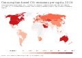
 Co-emissions-per-capita-map.png 3,400 × 2,700; 913 KB
-
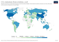
 CO2 emissions per capita, 2016 (Our World in Data).svg 850 × 600; 155 KB
-
 CO2 emissions per capita, 2017 (Our World in Data).svg 850 × 600; 155 KB
-
 CO2 per capita per country.png 800 × 370; 72 KB
-
 CO2 responsibility 1950-2000.svg 940 × 477; 1.98 MB
-
 Co2-emissions-aviation (OWID 0198).png 850 × 600; 103 KB
-
 Co2-emissions-domestic-aviation (OWID 0199).png 850 × 600; 102 KB
-
 CO2-emissions-per-capita-map.png 3,400 × 2,706; 1,002 KB
-
 Co2-international-aviation (OWID 0191).png 850 × 600; 101 KB
-
 Co2-land-use-per-capita (OWID 0187).png 850 × 600; 104 KB
-
 Consumption-based CO₂ emissions per capita, OWID.svg 850 × 600; 140 KB
-
 Consumption-based CO₂ emissions, OWID.svg 850 × 600; 141 KB
-
 Countries by carbon dioxide emissions world map deobfuscated.png 1,577 × 620; 56 KB
-
 Countries by carbon dioxide emissions world map.PNG 1,577 × 620; 39 KB
-
 Countries subscribed to the Montreal Protocol, OWID.svg 850 × 600; 139 KB
-
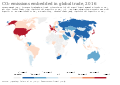 CO₂ emissions embedded in global trade, OWID.svg 850 × 600; 141 KB
-
 CO₂ emissions embedded in trade, OWID.svg 850 × 600; 141 KB
-
 CO₂ emissions per capita, OWID.svg 850 × 600; 140 KB
-
 Cumulative CO₂ emissions, OWID.svg 850 × 600; 141 KB
-
 Cumulative-co-emissions-from-other-industry (OWID 0225).png 850 × 600; 88 KB
-
 Cumulative-co-emissions.svg 850 × 600; 168 KB
-
 Distribution of committed CO2 emissions from developed fossil fuel reserves.jpg 1,725 × 2,176; 1.03 MB
-
 Doe cosources nov3.jpg 500 × 486; 48 KB
-
 Emission de CO2 dans le monde en 2011.png 1,005 × 602; 147 KB
-
 Emissions cumulatives CO2 2019.jpg 2,656 × 1,875; 1.18 MB
-
 ETS and carbon tax world map.svg 2,560 × 1,314; 6.47 MB
-
 Ga-1000tonrule.png 1,347 × 1,058; 704 KB
-
 Gazy cieplarniane na osobę 2000.svg 940 × 477; 2 MB
-
 GHG by country 2000.svg 940 × 477; 1.98 MB
-
 GHG by country 2005.png 1,800 × 820; 152 KB
-
 GHG intensity 2000.svg 940 × 477; 1.98 MB
-
 GHG per capita 2000 no LUC.svg 940 × 477; 1.98 MB
-
 GHG per capita 2000.jpg 746 × 397; 76 KB
-
 GHG per capita 2000.svg 940 × 477; 1.98 MB
-
 GHG per capita 2005.png 1,977 × 900; 169 KB
-
 Greenhouse gas emissions per capita per day, OWID.svg 850 × 600; 141 KB
-
 Imported or exported CO₂ emissions per capita, OWID.svg 850 × 600; 141 KB
-
 Map of methane emissions from four source categories.png 2,067 × 1,341; 322 KB
-
 Meat and Dairy CO2 Emissions - 20 largest emitters.png 2,066 × 1,351; 398 KB
-
Methane emissions from wetlands.webm 1 min 55 s, 1,920 × 1,080; 14.77 MB
-
 Midwestern Greenhouse Gas Reduction Accord parties map.svg 1,712 × 1,750; 216 KB
-
 NOAA-greenhouse-gases-till-2006-de.png 831 × 624; 31 KB
-
 Per-capita-co2-aviation (OWID 0794).png 850 × 600; 93 KB
-
 Per-capita-co2-international-aviation (OWID 0784).png 850 × 600; 104 KB
-
 Per-capita-ghg-emissions.png 3,400 × 2,400; 849 KB
-
 Ratio of GDP to carbon dioxide emissions.PNG 1,347 × 628; 31 KB
-
 Regional forest carbon loss and its drivers across the tropics during 2001–2019.webp 2,121 × 1,327; 191 KB
-
 RGGI member states.svg 959 × 593; 32 KB
-
 Share of global cumulative CO₂ emissions, OWID.svg 850 × 600; 140 KB
-
 Share-co2-emissions-aviation (OWID 0940).png 850 × 600; 105 KB
-
 Share-co2-international-aviation (OWID 0938).png 850 × 600; 102 KB
-
 Share-global-co2-domestic-aviation (OWID 1027).png 850 × 600; 99 KB
-

-

-
 Spatial pattern of forest carbon loss across the tropics.webp 1,827 × 1,186; 214 KB
-
 Status of net-zero carbon emissions targets map.png 3,400 × 2,400; 963 KB
-
 The 2011–2022 decadal mean components of the global carbon budget.png 2,067 × 1,447; 547 KB
-
 The 2013–2022 decadal mean components of the global carbon budget.png 2,067 × 1,447; 547 KB
-

-
 Total-ghg-emissions.png 3,400 × 2,400; 843 KB
-
 Total-greenhouse-gas-emissions-per-capita (OWID 1031).png 850 × 600; 91 KB
-
 Weighted-carbon-price-ets (OWID 1111).png 850 × 600; 120 KB
-
-
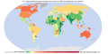
 World map of emission intensity 2018.svg 850 × 667; 131 KB
-
 World map of emission intensity.svg 850 × 667; 165 KB
-
 Yıllık CO₂ emisyonları, OWID.svg 850 × 600; 150 KB
-
 Zero-emission-vehicle-commitments (OWID 1093).png 850 × 600; 124 KB
-


.jpg)


.png)


.svg)
.svg)


.png)
.png)

.png)
.png)


.png)


.png)
.png)


.png)
.png)
.png)
.png)
.png)


.png)
.png)


.png)
