Category:Gloucestershire photographs taken on 2010-02-02
Jump to navigation
Jump to search
Subcategories
This category has only the following subcategory.
N
Media in category "Gloucestershire photographs taken on 2010-02-02"
The following 35 files are in this category, out of 35 total.
-
 A4136 leaving the forest - geograph.org.uk - 1726094.jpg 640 × 450; 60 KB
-
 Approaching Berry Hill Pike - geograph.org.uk - 1726168.jpg 640 × 434; 79 KB
-
 Braceland Cottages - geograph.org.uk - 1723895.jpg 640 × 480; 116 KB
-
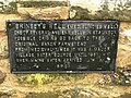
 Brindsey's Well - geograph.org.uk - 1725949.jpg 640 × 480; 119 KB
-
 Brindsey's Well - geograph.org.uk - 1725966.jpg 640 × 480; 132 KB
-
 Broom Hill - geograph.org.uk - 1723872.jpg 640 × 480; 118 KB
-
 Bunjups Wood - geograph.org.uk - 1725866.jpg 480 × 640; 143 KB
-
 Christchurch, green and church - geograph.org.uk - 1723844.jpg 640 × 480; 88 KB
-
 Farms east of The Kymin - geograph.org.uk - 1700764.jpg 640 × 412; 87 KB
-
 Fenced area, Lady Park Wood - geograph.org.uk - 1724342.jpg 640 × 480; 151 KB
-
 Footpath, Coalpit Hill - geograph.org.uk - 1724129.jpg 640 × 480; 147 KB
-
 Forest of Dean near Lady Park Wood - geograph.org.uk - 1724504.jpg 640 × 480; 131 KB
-
 Gamekeepers Inn, Five Acres - geograph.org.uk - 1726681.jpg 640 × 366; 51 KB
-
 Houses at Joyford - geograph.org.uk - 1723575.jpg 640 × 394; 91 KB
-
 In Knockalls Inclosure - geograph.org.uk - 1725873.jpg 640 × 480; 160 KB
-
 Junction, Christchurch - geograph.org.uk - 1723801.jpg 640 × 448; 121 KB
-
 Lane in Staunton - geograph.org.uk - 1725935.jpg 640 × 471; 94 KB
-
 Lay-by, Broadstones - geograph.org.uk - 1725724.jpg 640 × 462; 81 KB
-
 Lower Road, Five Acres - geograph.org.uk - 1726653.jpg 640 × 436; 78 KB
-
 Mossy rock, Redding's Inclosure - geograph.org.uk - 1700677.jpg 640 × 463; 145 KB
-
 Pasture, Rushmere Farm - geograph.org.uk - 1726065.jpg 640 × 480; 100 KB
-
 Path at Staunton - geograph.org.uk - 1725972.jpg 480 × 640; 127 KB
-
 Path in Blake's Wood - geograph.org.uk - 1726001.jpg 640 × 480; 160 KB
-
 Path junction, Whippington Brook valley - geograph.org.uk - 1724296.jpg 640 × 480; 115 KB
-
 Path, Marian's Inclosure - geograph.org.uk - 1726071.jpg 640 × 480; 141 KB
-
 Paths near Oldstone Well - geograph.org.uk - 1724313.jpg 640 × 480; 160 KB
-
 Ruin near Coleford - geograph.org.uk - 1723742.jpg 640 × 480; 130 KB
-
 Ruined building at Joyford - geograph.org.uk - 1723602.jpg 640 × 416; 92 KB
-
 Staunton - geograph.org.uk - 1725943.jpg 640 × 396; 71 KB
-
 The Dog and Muffler - geograph.org.uk - 1723673.jpg 640 × 480; 108 KB
-
 Track in Blake's Wood - geograph.org.uk - 1726033.jpg 640 × 480; 141 KB
-
 Track junction below Coalpit Hill - geograph.org.uk - 1724148.jpg 640 × 480; 150 KB
-
 Track junction, Staunton - geograph.org.uk - 1725995.jpg 640 × 480; 110 KB
-
 Valley at Joyford - geograph.org.uk - 1723781.jpg 640 × 423; 99 KB
-
 Working, Whippington Brook valley - geograph.org.uk - 1724232.jpg 640 × 480; 120 KB


