Category:Fronhof (Unkel)
Jump to navigation
Jump to search
| Object location | | View all coordinates using: OpenStreetMap |
|---|
building in Unkel, Germany   | |||||
| Upload media | |||||
| Instance of | |||||
|---|---|---|---|---|---|
| Location | Unkel, Neuwied, Rhineland-Palatinate, Germany | ||||
| Heritage designation | |||||
 | |||||
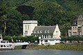
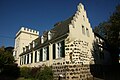
Deutsch: Fronhof in Unkel. Unkel erhielt seine Stadtbefestigung im Jahre 1553. Die Rheinseite erhielt die stärkste Mauer, sie wurde von dem Gefängnisturm und dem Turm des Fronhofs geschützt. Beide Türme sind nicht mehr im Original erhalten; der Turm des Fronhofs wurde 1803 im neugotischen Stil komplett umgebaut, der Gefängnisturm erhielt um 1700 ein neues Dach im barocken Stil.
Media in category "Fronhof (Unkel)"
The following 9 files are in this category, out of 9 total.
-
 2023 Unkel, Fronhof.jpg 2,231 × 2,228; 1.72 MB
-
 Fronhof Unkel 2.jpg 4,592 × 3,056; 4.68 MB
-
 Fronhof Unkel.jpg 4,592 × 3,056; 3.39 MB
-
 In Unkel, Rhineland-Palatinate, Germany, June 30th, 2018 (31).JPG 5,472 × 3,648; 9.26 MB
-
 In Unkel, Rhineland-Palatinate, Germany, June 30th, 2018 (32).JPG 3,648 × 5,472; 6.42 MB
-
 In Unkel, Rhineland-Palatinate, Germany, June 30th, 2018 (33).jpg 3,191 × 4,495; 8.62 MB
-
 In Unkel, Rhineland-Palatinate, Germany, June 30th, 2018 (34).jpg 4,600 × 3,477; 8.87 MB
-
 Unkel Von-Werner-Straße 8 Fronhof Hochwassermarken.jpg 2,164 × 2,071; 1.05 MB
-
 Unkel Von-Werner-Straße 8 Fronhof Informationstafel.jpg 4,378 × 2,523; 2.39 MB


.JPG)
.JPG)
.jpg)
.jpg)
