Category:Exterior of Klosterkirche St. Benedikt (Benediktbeuern)
Jump to navigation
Jump to search
| Object location | | View all coordinates using: OpenStreetMap |
|---|
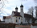
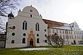
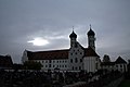
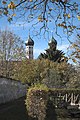
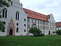
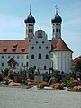
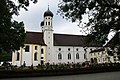
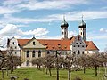
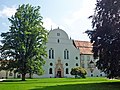
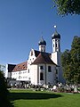
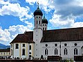
English: The Klosterkirche St. Benedikt (also called "Klosterbasilika" or "Basilika St. Benedikt") used to the minster of Benediktbeuern Abbey and today as the parish church of Benediktbeuern.
Media in category "Exterior of Klosterkirche St. Benedikt (Benediktbeuern)"
The following 49 files are in this category, out of 49 total.
-
 2006-04-01 Pfaffenwinkel, Allgäu 022 Benediktbeuern.jpg 2,592 × 1,944; 2.25 MB
-
 2021-01-02 Benediktbeuern 01 (50800487856).jpg 5,718 × 3,803; 10.35 MB
-
 2021-01-02 Benediktbeuern 02 (50800604257).jpg 5,915 × 3,873; 14.37 MB
-
 2021-01-02 Benediktbeuern 04 (50799745788).jpg 6,000 × 4,000; 12.65 MB
-
 2021-01-02 Benediktbeuern 08 (50799752388).jpg 3,892 × 5,928; 16.19 MB
-
 Basilika des Klosters Benediktbeuern.jpg 3,084 × 4,428; 8.38 MB
-
 Basilika Kloster Benediktbeuern 02.JPG 1,920 × 1,080; 873 KB
-
 Benediktbeuern 6803.jpg 2,048 × 1,536; 1.71 MB
-
 Benediktbeuern Abbey (2038341327).jpg 1,024 × 683; 79 KB
-
 Benediktbeuern Kloster Benediktbeuern 1.JPG 2,048 × 1,536; 1.46 MB
-
 Benediktbeuern Kloster Benediktbeuern 2.JPG 2,048 × 1,536; 1.44 MB
-
 Benediktbeuern Kloster Benediktbeuern 4.JPG 2,048 × 1,536; 1.45 MB
-
 Benediktbeuern Kloster Benediktbeuern 5.JPG 1,536 × 2,048; 1.46 MB
-
 Benediktbeuern Kloster Benediktbeuern Kirche Front 1.JPG 2,048 × 1,536; 1.48 MB
-
 Benediktbeuern Kloster Benediktbeuern Kirche Front 2.JPG 2,048 × 1,536; 1.5 MB
-
 Benediktbeuern Kloster Benediktbeuern Kirche Front 3.JPG 1,536 × 2,048; 1.44 MB
-
 Benediktbeuern Klosterkirche St. Benedikt Alpen 881.jpg 4,760 × 3,173; 9.63 MB
-
 Benediktbeuern St. Benedikt 912.jpg 3,264 × 4,896; 13.48 MB
-
 Benediktbeuern St. Benedikt 916.jpg 4,896 × 3,264; 11.52 MB
-
 Benediktbeuern St. Benedikt 922.jpg 4,896 × 3,264; 10.82 MB
-
 Benediktbeuern St. Benedikt 926.jpg 3,174 × 4,761; 9.02 MB
-
 Benediktbeuern St. Benedikt 960.jpg 3,264 × 4,896; 8.97 MB
-
 Benediktbeuern St. Benedikt 964.jpg 3,264 × 4,896; 12.03 MB
-
 Benediktbeuern St. Benedikt 967.jpg 4,896 × 3,264; 9.25 MB
-
 Benediktbeuern St. Benedikt 972.jpg 4,896 × 3,264; 15.1 MB
-
 Benediktbeuern St. Benedikt 973.jpg 4,896 × 3,264; 12.71 MB
-
 Benediktbeuern St. Benedikt 974.jpg 4,896 × 3,264; 18.29 MB
-
 Benediktbeuern St. Benedikt 975.jpg 3,264 × 4,896; 15.94 MB
-
 Benediktbeuern und Benediktenwand.JPG 2,400 × 1,600; 2.05 MB
-
 Benediktbeuern von Norden.jpg 2,848 × 2,136; 1.39 MB
-
 Benediktbeuern, Innenhof mit Eingang zur Klosterkirche.jpg 2,848 × 2,136; 1.4 MB
-
 Benediktbeuern.jpg 768 × 1,024; 454 KB
-
 BY-benediktbeuern-baslika-nordseite.jpg 1,215 × 807; 486 KB
-
 Die Barocktürme von Koster Benediktbeuern.jpg 4,591 × 2,580; 5.07 MB
-
 Die Basilika des ehemaligen Benediktinerkloster in Benediktbeuern.jpg 5,114 × 3,220; 8.4 MB
-
 Benediktbeuern Abbey wall detail (2038341609).jpg 1,132 × 1,374; 251 KB
-
 Karfreitagsratsche 01.jpg 2,448 × 3,264; 1.65 MB
-
 Kloster Benediktbeuern 06.jpg 4,242 × 2,386; 6.09 MB
-
 Kloster Benediktbeuern Klosterkirche Stankt Benedikt 1.jpg 4,416 × 3,312; 7.54 MB
-
 Kloster Benediktbeuern-1.jpg 1,024 × 768; 161 KB
-
 Kloster Benediktbeuern-2.jpg 768 × 1,024; 162 KB
-
 KlosterBenediktbeuern1.jpg 1,950 × 1,453; 1.04 MB
-
 KlosterBenediktbeuern8.jpg 1,837 × 1,378; 898 KB
-
 Klosterkirche St. Benedikt (Benediktbeuern) 2010 009.jpg 1,536 × 2,048; 1.28 MB
-
 Klosterkirche St. Benedikt Benediktbeuern 01.jpg 4,092 × 2,728; 5.9 MB
-
 Klosterkirche St. Benedikt Benediktbeuern 02.jpg 4,299 × 2,866; 7.07 MB
-
 Klosterkirche St. Benedikt Benediktbeuern 03.jpg 4,287 × 3,190; 5.71 MB
-
 Kreuzgang-Benediktbeuern1.jpg 2,269 × 2,004; 1.03 MB
-
 Tafel-Benediktbeuern.jpg 2,331 × 1,717; 538 KB

.jpg)
.jpg)
.jpg)
.jpg)


.jpg)


.jpg)


_2010_009.jpg)


