Category:English-language maps of Alabama
Jump to navigation
Jump to search
States of the United States: Alabama · Alaska · Arkansas · California · Florida · Maryland · Massachusetts · New Jersey · New Mexico · New York · North Carolina · Ohio · Oklahoma · Pennsylvania · Texas · Utah – Washington, D.C.
Media in category "English-language maps of Alabama"
The following 17 files are in this category, out of 17 total.
-
 Alabama LOC 2006629778.jpg 3,515 × 4,484; 1.95 MB
-
 Alabama WV regions map EN.png 1,600 × 2,338; 949 KB
-
 Base map of Alabama. LOC 2005625108.jpg 7,110 × 6,061; 5.49 MB
-
 Coal Producing Districts and Fields - State of Alabama - DPLA - 4d0a41e26fbb0a68cd4c5f7a5a69c42d.jpg 9,164 × 13,944; 20.51 MB
-
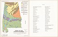 General soil map, state of Alabama LOC 90684182.jpg 5,164 × 3,335; 1.61 MB
-
 General soil map, State of Alabama LOC 90684183.jpg 5,692 × 7,161; 7.01 MB
-
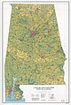 Land use and land cover, state of Alabama LOC 85696121.jpg 9,102 × 13,555; 22.2 MB
-
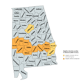 Majority minority counties in Alabama 2020 Census.png 4,244 × 4,244; 1.13 MB
-
 Map of Alabama showing soil and water conservation district organization. LOC gm69002242.jpg 3,644 × 5,590; 1.85 MB
-

-
 Resource conservation and development areas, Alabama LOC 93682955.jpg 2,538 × 3,281; 747 KB
-
 Soil areas of Alabama LOC 2001624637.jpg 5,162 × 3,331; 2.22 MB
-
 Soil areas of Alabama LOC 90684181.jpg 5,175 × 3,335; 2.13 MB
-
 State of Alabama - DPLA - a3928665401572aaeb9bceebb7a4330a.jpg 6,864 × 10,340; 5.88 MB
-
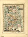
 State of Alabama. October. 2nd. 1866. LOC 98688440.jpg 3,560 × 5,760; 3.48 MB
-
 Transportation map of Alabama. LOC 77694767.jpg 5,065 × 6,571; 3.48 MB
-
 Transportation map of Alabama. LOC 77694814.jpg 5,084 × 6,548; 3.31 MB


,_Geographer_to_the_House_of_Representatives_of_the_LOC_98688462.jpg)


