Category:Dunlap's Creek Bridge
| Dunlap's Creek Bridge along the Emigrant Trail to the near west Northwest Territory (and successors) on Market Street in historic downtown Brownsville, Pennsylvania, a gateway city on the west side of the Appalachians barrier range. | ||
|---|---|---|
 |
 |
 |
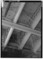
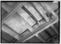
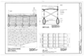
Dunlap's Creek Bridge was the first cast iron, metal arch bridge in the United States. It was designed by Richard Delafield and built by the United States Army Corps of Engineers.[1] Constructed from 1836 to 1839 on the National Road in Brownsville, Pennsylvania enroute to the Brownsville Bridge to Washington County, PA, it remains in use today. It is listed on the National Register of Historic Places and is a National Historic Civil Engineering Landmark (1978).

It is located in the Brownsville Commercial Historic District and supports lower Market Street, the local main thoroughfare and lower town 'main street'. Facing north from Dunlap's Creek, looking up Market Street and along the eastward direction of National Road, the town and street layout forms the shape of a huge check-mark, climbing for several city blocks, then bending sharply more than 90 degrees and climbing the ridge of the drainage divide between the two tributary valleys to far off Cumberland, Maryland at the head of the Potomac River and the port of Baltimore, Maryland. This made each of these municipalities a key overland waypoint on the near-west Emigrant Trail as Americans began colonizing the midwest.
• Due to the steep sides of the Monongahela River valley, there is only room for two short streets parallel to the river's shore and graded mild enough to be comfortable to walk before the terrain rises too steeply for business traffic. BOTH are visible in this view. The square concrete arch is actually a building foundation, the other lower street is visible in the far distance.
• Background: Two right bank large tributary streams of the Monongahela River drainage basin along the west side of the Allegheny Mountains barrier range, Redstone Creek and Dunlap's Creek, created conditions that formed a valuable ramp-like sloped terrain enabling Amerindians (for centuries) and colonials to reach a ford (crossing) the wide barrier of the Monongahela. Descending between the two small rivers, Nemacolin's Trail/the National Pike path has to cross Dunbar street to reach the ford on the upstream side of the confluence. The same two creeks and cross-river flats of West Brownsville, Pennsylvania became centers of river boat construction, giving Brownsville a historic edge as a industrial and outfitting center in near-western communities keeping it larger than Pittsburgh into the 1850s.
| Object location | | View all coordinates using: OpenStreetMap |
|---|
bridge in United States of America | |||||
| Upload media | |||||
| Instance of | |||||
|---|---|---|---|---|---|
| Location | Brownsville, Fayette County, Pennsylvania | ||||
| Crosses |
| ||||
| Carries | |||||
| Heritage designation |
| ||||
 | |||||
References[edit]
- ↑ Jackson, Donald C. (1996) Great American Bridges and Dams, Category:New York: Wiley ISBN: 0-471-14385-5.
- ↑ Location from NRHP places in Fayette County
Media in category "Dunlap's Creek Bridge"
The following 23 files are in this category, out of 23 total.
-
-
 Brownsville, PA looking over Dunlap's Creek .jpg 4,000 × 2,250; 3.54 MB
-
-

-
 Dunlap creek bridge jet lowe 1983.jpg 1,024 × 815; 113 KB
-
 Dunlap's Creek Bridge, northern side.jpg 2,112 × 2,816; 2.8 MB
-
 Dunlap's Creek Bridge, railing.jpg 2,816 × 2,112; 2.61 MB
-
 Dunlap's Creek Bridge, southern side.jpg 2,112 × 2,816; 2.68 MB
-

-

-
-

-

-

-
 DunlapsCreekBridge.jpg 1,280 × 960; 610 KB
-
 Dunlap’s Creek Bridge 1894.jpg 518 × 400; 15 KB
-

-

-

-
 Isometric drawing of the Dunlap’s Creek Bridge.jpg 3,200 × 2,130; 1.41 MB
-

-

-


.png)
.png)
.png)


- Built in Pennsylvania in 1839
- 1830s bridges in Pennsylvania
- Bridges in the United States completed in 1839
- Bridges in Fayette County, Pennsylvania
- Brownsville Commercial Historic District
- Cast-iron arch bridges
- Iron road bridges in the United States
- National Historic Civil Engineering Landmarks
- National Historic Civil Engineering Landmarks in Pennsylvania
- Deck arch bridges in Pennsylvania
- National Road
- Brownsville, Pennsylvania
- Richard Delafield