Category:DuPont Building (Wilmington, Delaware)
Jump to navigation
Jump to search
| Object location | | View all coordinates using: OpenStreetMap |
|---|
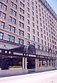
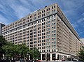
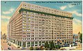
The DuPont Building, occupying the entire block bound by 10th, 11th, Orange and Market streets, was one of the first high-rises in Wilmington, Delaware  | |||||
| Upload media | |||||
| Instance of | |||||
|---|---|---|---|---|---|
| Location | Wilmington, New Castle County, Delaware | ||||
| Owned by | |||||
| Occupant |
| ||||
| Inception |
| ||||
| Date of official opening |
| ||||
| official website | |||||
 | |||||
Media in category "DuPont Building (Wilmington, Delaware)"
The following 11 files are in this category, out of 11 total.
-
 Brandywine Valley Scenic Byway - Hotel du Pont in Downtown Wilmington - NARA - 7717471.jpg 2,259 × 3,300; 2.01 MB
-
 Brandywine Valley Scenic Byway - The Hotel du Pont Green Room - NARA - 7717472.jpg 2,100 × 3,000; 4.36 MB
-
 DuPont Bldg.jpg 2,956 × 2,290; 2.27 MB
-
 DuPont Building, 11thStWall.JPG 576 × 768; 99 KB
-
 DuPont Building.jpg 1,910 × 1,421; 2.61 MB
-
 DuPont Hotel and Nemours building, Wilmington, Delaware (66693).jpg 3,335 × 2,051; 2.92 MB
-
 Dupontat10th.JPG 468 × 704; 98 KB
-
 Hotel Du Pont, showing Rodney Square, Wilmington, Del (62229).jpg 3,321 × 2,100; 3.37 MB
-
 Hotel DuPont cornerstone.jpg 2,048 × 1,536; 1.04 MB
-
 Hotel DuPont lobby, Wilmington, Delaware (72217).jpg 3,315 × 2,142; 3 MB
-
 Hotel Rodney, Market St., Wilmington, Del (72641).jpg 3,340 × 2,163; 2.74 MB


.jpg)

.jpg)

.jpg)
.jpg)
Categories:
- DuPont buildings
- High-rises in Wilmington, Delaware
- High-rise hotels in Delaware
- Built in Delaware in 1908
- High-rises in the United States built in 1908
- Corporate headquarters in Delaware
- High-rise office buildings in Delaware
- 23-49-meter-tall buildings in Delaware
- 38-meter-tall buildings in the United States
- Rodney Square Historic District
- Theaters in Delaware
- Historic Hotels of America
- Preferred Hotels & Resorts
- Historic Hotels Worldwide