Category:Dorfkirche (Thundorf i. Ufr.)
Jump to navigation
Jump to search
| Object location | | View all coordinates using: OpenStreetMap |
|---|
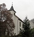
This is the category of the Bavarian Baudenkmal (cultural heritage monument) with the ID D-6-72-157-10 (Wikidata)
|
cultural heritage monument D-6-72-157-10 (0) in Thundorf in Unterfranken, Bavaria | |||||
| Upload media | |||||
| Instance of | |||||
|---|---|---|---|---|---|
| Location | Thundorf in Unterfranken, Bad Kissingen, Lower Franconia, Bavaria, Germany | ||||
| Street address |
| ||||
| Heritage designation | |||||
 | |||||
Media in category "Dorfkirche (Thundorf i. Ufr.)"
The following 12 files are in this category, out of 12 total.
-
 Ev. Ki. Thundorf inn.jpg 4,608 × 3,456; 3.9 MB
-
 Ev. Kir. Thundorf.jpg 2,995 × 3,273; 2.09 MB
-
 Ev. Kirche Thundorf innen.jpg 4,608 × 3,456; 3.77 MB
-
 Thundorf 002.JPG 3,264 × 4,928; 3.77 MB
-
 Thundorf 005.JPG 3,264 × 4,928; 3.23 MB
-
 Thundorf i.Ufr., Ev. Kirche, 001.jpg 4,928 × 3,264; 8.66 MB
-
 Thundorf i.Ufr., Ev. Kirche, 002.jpg 4,928 × 3,264; 7.75 MB
-
 Thundorf, D-6-72-157-10 Maßbach 20221008 0241.jpg 3,583 × 5,385; 15.9 MB
-
 Thundorf, D-6-72-157-10 Maßbach 20221008 0242.jpg 3,849 × 5,785; 16.04 MB
-
 Thundorf, D-6-72-157-10 Maßbach 20221008 0243.jpg 3,553 × 5,340; 10.36 MB
-
 Thundorf, D-6-72-157-10 Maßbach 20221008 0244.jpg 3,843 × 5,776; 14.76 MB
-
 Thundorf, D-6-72-157-10 Maßbach 20221008 0269.jpg 5,378 × 3,578; 16.06 MB


