Category:Der erhobene Zeigefinger (Ringelnatzpfad)
Jump to navigation
Jump to search
| Object location | | View all coordinates using: OpenStreetMap |
|---|
Media in category "Der erhobene Zeigefinger (Ringelnatzpfad)"
The following 5 files are in this category, out of 5 total.
-
 WUR-RingelnatzpfadDom.JPG 2,671 × 3,596; 1.54 MB
-
 Wurzen - Domplatz + Ringelnatzpfad - Der erhobene Zeigefinger 01 ies.jpg 5,616 × 3,744; 19.96 MB
-
 Wurzen - Domplatz + Ringelnatzpfad - Der erhobene Zeigefinger 02 ies.jpg 3,745 × 5,616; 22.24 MB
-
 Wurzen - Domplatz + Ringelnatzpfad - Der erhobene Zeigefinger 03 ies.jpg 3,744 × 5,616; 15.88 MB
-
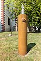 Wurzen Ringelnatzstele 4.jpg 3,648 × 5,472; 3.05 MB


