Category:Cope Butte
Jump to navigation
Jump to search

.jpg)
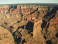
(south)-Hermit Canyon, Cope Butte, Granite Rapid
Land formation in the Grand Canyon of Arizona | |||||
| Upload media | |||||
| Location | Arizona | ||||
|---|---|---|---|---|---|
 | |||||
English: Cope Butte opposite Ninetyfour Mile Canyon & Creek, across west Granite Gorge, on the Colorado River.
- Located in Monument Canyon (lower canyon), at the canyon terminus, on west flank of canyon.
Also on east flank terminus of w:Hermit Canyon. - The w:Hermit Trail traverses down the west flank of Cope Butte. The w:Tonto Trail, traverses the northwest, north, and northeast of Cope Butte.
- Located in Monument Canyon (lower canyon), at the canyon terminus, on west flank of canyon.
Subcategories
This category has the following 6 subcategories, out of 6 total.
C
- Cope Butte (east aspect) (5 F)
- Cope Butte (north aspect) (5 F)
- Cope Butte (west aspect) (7 F)
H
R
- Remote views of Cope Butte (2 F)
T
Media in category "Cope Butte"
The following 17 files are in this category, out of 17 total.
-
 131112-Z-WT236-003 (10855083144).jpg 3,600 × 2,400; 2.35 MB
-
 Arizona. LOC 99446124-3.jpg 6,534 × 8,020; 11.28 MB
-
 Arizona. LOC 99446126-2.jpg 5,014 × 6,252; 6.24 MB
-
 Cope Butte from Boucher Trail.jpg 1,024 × 768; 420 KB
-
 Cope Butte from Tonto Trail.jpg 4,000 × 3,000; 4.06 MB
-
 Cope Butte, (East Flank), at Granite Gorge, and West Flank of Lower Monument Canyon, GC.png 1,125 × 2,001; 10.21 MB
-
 Grand Canyon (3696027995).jpg 1,200 × 1,800; 915 KB
-
 Grand Canyon Colorado River (col riv) (5738162654).jpg 1,996 × 3,000; 2.13 MB
-
 Grand Canyon Flora.JPG 2,448 × 3,264; 3.81 MB
-
 Grand Canyon Village, AZ 86023, USA - panoramio (40).jpg 2,048 × 1,160; 1.04 MB
-
 Grand Canyon Village, AZ 86023, USA - panoramio (44).jpg 2,048 × 1,153; 803 KB
-
 Grand Canyon Village, AZ 86023, USA - panoramio (48).jpg 2,048 × 1,153; 1.04 MB
-
 Grand Canyon.jpg 1,600 × 1,200; 357 KB
-
 GrandCanyon1991.jpg 3,309 × 1,982; 4.59 MB
-
 Harvey Butchart's hiking map - Flickr - brewbooks (6).jpg 3,264 × 2,448; 4.13 MB
-
 Hermit Trail.jpg 3,100 × 1,497; 2.97 MB
-

.jpg)


,_at_Granite_Gorge,_and_West_Flank_of_Lower_Monument_Canyon,_GC.png)
.jpg)
_(5738162654).jpg)

.jpg)
.jpg)


.jpg)

,_(lower_canyon),_Mohave_Point,_Cope_Butte,_The_Alligator_(landform).png)