Category:Cilgerran
Jump to navigation
Jump to search
village and community in Pembrokeshire, Wales   | |||||
| Upload media | |||||
| Instance of | |||||
|---|---|---|---|---|---|
| Location | Pembrokeshire, Wales | ||||
| Population |
| ||||
| Area |
| ||||
 | |||||
Subcategories
This category has the following 3 subcategories, out of 3 total.
C
- St Llawddogs, Cilgerran (10 F)
S
Media in category "Cilgerran"
The following 200 files are in this category, out of 202 total.
(previous page) (next page)-

-
 A view of Cilgerran castle from the quarry NLW3361149.jpg 583 × 446; 66 KB
-
 A woodland path - geograph.org.uk - 1877898.jpg 800 × 600; 156 KB
-
 A478 heading for Bridell - geograph.org.uk - 3748129.jpg 640 × 480; 69 KB
-
 A487 heading for Llantood - geograph.org.uk - 3748063.jpg 640 × 480; 39 KB
-

-
 Abandoned tractor near Dan-yr-allt Farm - geograph.org.uk - 2395899.jpg 640 × 480; 154 KB
-
 Afon Teifi - geograph.org.uk - 4726409.jpg 1,600 × 1,064; 469 KB
-
 Afon Teifi and ruined house - geograph.org.uk - 4726417.jpg 1,600 × 1,064; 495 KB
-
 Afon Teifi at the Coracle Centre, Cilgerran - geograph.org.uk - 5195008.jpg 2,000 × 1,500; 988 KB
-
 Afon Teifi from Cilgerran castle - geograph.org.uk - 2591855.jpg 3,872 × 2,592; 5.27 MB
-
 Archway into inner bailey, Cilgerran Castle - geograph.org.uk - 5911491.jpg 5,179 × 3,451; 5.25 MB
-
 B4332 north of The Meigans - geograph.org.uk - 2647080.jpg 3,328 × 2,434; 1.2 MB
-
 Babell Chapel (CM), Cilgerran NLW3361154.jpg 592 × 448; 57 KB
-
 Babell Chapel, Cilgerran - geograph.org.uk - 2591902.jpg 3,872 × 2,592; 3.93 MB
-
 Baptist Chapel, Pen-y-Bryn - geograph.org.uk - 6305008.jpg 4,032 × 3,024; 1.9 MB
-
 Bend on the Afon Teifi - geograph.org.uk - 4726422.jpg 1,600 × 1,064; 543 KB
-
 Boys on bikes - geograph.org.uk - 445730.jpg 640 × 498; 95 KB
-
 Bridge to inner bailey, Cilgerran Castle - geograph.org.uk - 5912332.jpg 5,179 × 3,451; 4.79 MB
-
 Buttercup meadow - geograph.org.uk - 1931430.jpg 800 × 600; 136 KB
-
 Canoeist on Afon Teifi - geograph.org.uk - 2591981.jpg 3,872 × 2,592; 5.42 MB
-
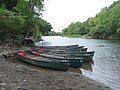 Canoes on the Teifi - geograph.org.uk - 445722.jpg 640 × 480; 101 KB
-
 Car Park Pentood Marsh - geograph.org.uk - 4584212.jpg 640 × 428; 108 KB
-
 Cardiff Arms, Cilgerran - geograph.org.uk - 2591914.jpg 3,872 × 2,592; 3.55 MB
-
 Castell Malgwyn Country Hotel - geograph.org.uk - 2761912.jpg 1,024 × 768; 731 KB
-
 Castell Malgwyn tunnel, looking east - geograph.org.uk - 1929428.jpg 800 × 600; 159 KB
-
 Castell Malgwyn tunnel, looking west - geograph.org.uk - 1929098.jpg 800 × 600; 185 KB
-
 CCF Feed Blending Plant, Llantood - geograph.org.uk - 4887168.jpg 2,560 × 1,290; 2.54 MB
-
 Church Road, Cilgerran - geograph.org.uk - 5195045.jpg 2,000 × 1,500; 879 KB
-
 Cilgerran Castle - geograph.org.uk - 6026387.jpg 2,000 × 1,363; 2 MB
-
 Cilgerran Coracle Centre - geograph.org.uk - 2395848.jpg 640 × 480; 104 KB
-
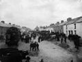 Cilgerran fair NLW3361159.jpg 589 × 447; 43 KB
-
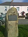 Cilgerran Millennium Stone.jpg 3,456 × 4,608; 5.53 MB
-
 Cilgerran old building 120904 (Tony Holkham).jpg 4,000 × 3,000; 4.25 MB
-
 Cilgerran time capsule.jpg 3,456 × 4,608; 7.41 MB
-
 Cilgerran Town.jpg 800 × 533; 121 KB
-
 Cilgerran water pump.jpg 4,608 × 3,456; 9.64 MB
-
 Cilgerran, Pembrokeshire - geograph.org.uk - 3982283.jpg 1,920 × 1,267; 1.47 MB
-
 Coedmore Mansion, Ceredigion - geograph.org.uk - 5911403.jpg 5,184 × 3,456; 7.21 MB
-
 Contrasting style of stiles - geograph.org.uk - 2395951.jpg 640 × 480; 136 KB
-
 Coracle Racing on the Teifi - geograph.org.uk - 4481503.jpg 4,288 × 2,848; 3.8 MB
-
 Corner house - geograph.org.uk - 1877863.jpg 800 × 600; 145 KB
-

-
 Cottages next to Cilgerran Castle - geograph.org.uk - 5910662.jpg 5,179 × 3,451; 4.85 MB
-
 County Boundary - geograph.org.uk - 4810912.jpg 1,600 × 1,067; 260 KB
-
 Croft Farm cottages - geograph.org.uk - 1877851.jpg 800 × 600; 149 KB
-

-
 Crossing Afon Piliau - geograph.org.uk - 1879317.jpg 800 × 600; 147 KB
-
 Decorative churns - geograph.org.uk - 636877.jpg 640 × 486; 105 KB
-
 Disused quarry near Cwm Morgenau - geograph.org.uk - 1929507.jpg 800 × 600; 145 KB
-
 Dog Food Dave - geograph.org.uk - 2591938.jpg 3,872 × 2,592; 3.78 MB
-
 Down the street at Llwyncelyn - geograph.org.uk - 1931416.jpg 600 × 800; 118 KB
-
 Drawbridge entrance to Cilgerran Castle - geograph.org.uk - 6009830.jpg 1,060 × 1,600; 425 KB
-
 Entrance to Cilgerran Castle - geograph.org.uk - 5910699.jpg 5,179 × 3,451; 5.45 MB
-
 Fields around Rhos-fâch, Llantood - geograph.org.uk - 2493230.jpg 1,500 × 1,132; 1.16 MB
-
 Footbridge on footpath - geograph.org.uk - 1877878.jpg 800 × 600; 153 KB
-
 Footbridge over Afon Piliau - geograph.org.uk - 1880981.jpg 800 × 600; 150 KB
-
 Footpath junction below Cilgerran Castle - geograph.org.uk - 5910624.jpg 5,179 × 3,451; 5.31 MB
-
 Footpath through woods - geograph.org.uk - 1877921.jpg 600 × 800; 156 KB
-

-
 Frost in the valley - geograph.org.uk - 635336.jpg 640 × 480; 79 KB
-
 Garnon's Mill - geograph.org.uk - 1931096.jpg 800 × 600; 164 KB
-
 Garnon's Mill Road, Cilgerran - geograph.org.uk - 1929522.jpg 800 × 600; 152 KB
-
 Gezicht op de rivier Teifi in Pembrokeshire, Wales, RP-F-2001-7-1151-4.jpg 4,962 × 3,688; 1.88 MB
-
 Giant willow badger at the Teifi Marshes Wildlife Centre - geograph.org.uk - 4623581.jpg 4,000 × 2,400; 2.68 MB
-
 Halfway, Llantood - geograph.org.uk - 4887121.jpg 2,560 × 1,573; 2.34 MB
-
 Head of creek, Afon Teifi, Teifi Marshes Nature Reserve - geograph.org.uk - 5552804.jpg 5,179 × 3,451; 4.65 MB
-

-

-
 High Street at the Methodist Chapel, Cilgerran - geograph.org.uk - 5194975.jpg 2,000 × 1,452; 723 KB
-
 High Street at the Village Stores, Cilgerran - geograph.org.uk - 5195003.jpg 2,000 × 1,478; 716 KB
-
 High Street, Cilgerran - geograph.org.uk - 2591942.jpg 3,872 × 2,592; 4.25 MB
-
 High Street, Cilgerran - geograph.org.uk - 5194997.jpg 2,000 × 1,463; 938 KB
-
 Hoof fungus, Fomes fomentarius - geograph.org.uk - 636360.jpg 460 × 640; 117 KB
-
 Impressive Topiary Arch - geograph.org.uk - 2802683.jpg 3,264 × 2,448; 4.39 MB
-
 In a plantation near Cilgerran - geograph.org.uk - 2612043.jpg 640 × 480; 91 KB
-
 In the grounds of Castell Malgwyn - geograph.org.uk - 1929451.jpg 800 × 600; 159 KB
-
 In woodland above the Teifi - geograph.org.uk - 2612016.jpg 640 × 480; 143 KB
-
 Industrial units on the edge of Cilgerran - geograph.org.uk - 2591961.jpg 3,872 × 2,592; 3.69 MB
-
 Junction along the A487 near Llantood - geograph.org.uk - 6357155.jpg 800 × 550; 106 KB
-
 Kilgerran Halt site geograph-3721351-by-Ben-Brooksbank.jpg 2,396 × 1,444; 3.59 MB
-
 Kingfisher Ponds - geograph.org.uk - 4584220.jpg 640 × 428; 98 KB
-
 Lily Gower's croquet lawn - geograph.org.uk - 1927384.jpg 800 × 600; 147 KB
-
 Looking down into Cwm Morgenau - geograph.org.uk - 1929469.jpg 800 × 600; 155 KB
-
 Macbeth at Cilgerran - geograph.org.uk - 214182.jpg 640 × 480; 110 KB
-
 Margaret y Gwehydd (Margaret the Weaver), Cilgerran NLW3363807.jpg 426 × 596; 47 KB
-
 Masons Arms, Cilgerran - geograph.org.uk - 2591956.jpg 3,872 × 2,592; 4.33 MB
-

-
 North along the A487 - geograph.org.uk - 6357191.jpg 800 × 503; 136 KB
-
 Old bowl at Cwm - geograph.org.uk - 1879861.jpg 800 × 600; 180 KB
-
 Old carriage road from Castell Malgwyn - geograph.org.uk - 1928685.jpg 800 × 600; 152 KB
-
 Old chapel in Cilgerran - geograph.org.uk - 6257711.jpg 640 × 480; 90 KB
-
 Old farm buildings - geograph.org.uk - 2612029.jpg 640 × 480; 127 KB
-
 Old pub in Cilgerran - geograph.org.uk - 6257709.jpg 640 × 480; 57 KB
-
 Old relics in Cilgerran - geograph.org.uk - 2395864.jpg 640 × 480; 67 KB
-

-
 Orange-tip heaven - geograph.org.uk - 1880957.jpg 800 × 600; 135 KB
-
 Ordnance Survey Cut Mark - geograph.org.uk - 6393447.jpg 1,024 × 886; 466 KB
-
 Ordnance Survey Cut Mark - geograph.org.uk - 6393448.jpg 1,024 × 795; 251 KB
-
 Ordnance Survey Cut Mark - geograph.org.uk - 6394823.jpg 559 × 1,024; 237 KB
-
 Ordnance Survey Cut Mark - geograph.org.uk - 6394824.jpg 1,024 × 797; 277 KB
-
 Ordnance Survey Cut Mark - geograph.org.uk - 6394827.jpg 1,024 × 867; 313 KB
-
 Ordnance Survey Cut Mark - geograph.org.uk - 6394828.jpg 1,024 × 749; 283 KB
-
 Ordnance Survey Cut Mark - geograph.org.uk - 6394829.jpg 1,024 × 654; 213 KB
-
 Ordnance Survey Cut Mark - geograph.org.uk - 6394834.jpg 1,024 × 847; 198 KB
-
 Ordnance Survey Cut Mark - geograph.org.uk - 6394836.jpg 1,024 × 807; 237 KB
-
 Ordnance Survey Flush Bracket (11880) - geograph.org.uk - 6393446.jpg 836 × 1,024; 355 KB
-

-
 Ordnance Survey Flush Bracket (S7803) - geograph.org.uk - 4461820.jpg 480 × 640; 113 KB
-
 Ordnance Survey Flush Bracket S0665 - geograph.org.uk - 3482902.jpg 4,000 × 3,000; 5.01 MB
-
 Ordnance Survey Flush Bracket S7802 - geograph.org.uk - 3483014.jpg 4,000 × 3,000; 3.14 MB
-
 Ordnance Survey Flush Bracket S7803 - geograph.org.uk - 3482946.jpg 4,000 × 3,000; 3.81 MB
-
 Ordnance Survey Rivet - geograph.org.uk - 6394826.jpg 1,024 × 879; 246 KB
-
 Ordnance Survey Rivet - geograph.org.uk - 6394831.jpg 557 × 1,024; 222 KB
-
 Overlooking the Teifi, Cilgerran - geograph.org.uk - 5549696.jpg 5,179 × 3,451; 4.9 MB
-
 Pantygrwndy - geograph.org.uk - 4810922.jpg 1,600 × 894; 179 KB
-

-

-
 Part of the High Street in Cilgerran - geograph.org.uk - 6257715.jpg 640 × 480; 103 KB
-
 Part of Ty-hen Farm - geograph.org.uk - 2395944.jpg 640 × 480; 139 KB
-
 Path high above the Afon Teifi - geograph.org.uk - 2612023.jpg 640 × 480; 144 KB
-
 Path on the woodland edge - geograph.org.uk - 2612037.jpg 640 × 480; 142 KB
-
 Pen-y-bryn, Baptist Chapel - geograph.org.uk - 2680418.jpg 3,589 × 2,656; 1.15 MB
-
 Penuel Baptist Chapel, Cilgerran - geograph.org.uk - 2591923.jpg 3,872 × 2,592; 3.46 MB
-
 Penybryn Baptist Chapel, Cilgerran - geograph.org.uk - 6257717.jpg 640 × 480; 70 KB
-
 Picnic area at the Welsh Wildlife Centre - geograph.org.uk - 3015236.jpg 4,000 × 3,000; 3.33 MB
-
 Picnic table at the riverside car park, Cilgerran - geograph.org.uk - 5195031.jpg 2,000 × 1,500; 1.26 MB
-
 Picnic tables, Cilgerran Castle - geograph.org.uk - 5911480.jpg 5,179 × 3,451; 5.52 MB
-
 Plas-y-Bridell. - geograph.org.uk - 2802702.jpg 3,264 × 2,448; 3.74 MB
-
 Play area at Teifi Marshes - geograph.org.uk - 2612003.jpg 640 × 480; 135 KB
-
 Pontrhydyceirt - geograph.org.uk - 1931214.jpg 800 × 600; 136 KB
-
 Red Campion (Melandrum rubrium) - geograph.org.uk - 430143.jpg 640 × 426; 124 KB
-
 Revd J M Davies, Cilgerran NLW3364624.jpg 429 × 601; 30 KB
-
 Riverside footpath, Cilgerran - geograph.org.uk - 5912356.jpg 5,184 × 3,456; 6.13 MB
-
 Riverside path - geograph.org.uk - 4726420.jpg 1,600 × 1,064; 763 KB
-

-
 Ruined home in woodland - geograph.org.uk - 2395956.jpg 640 × 480; 164 KB
-
 Ruined house by the Afon Teifi - geograph.org.uk - 4726428.jpg 1,600 × 1,064; 572 KB
-
 Run aground in the rain on Afon Teifi - geograph.org.uk - 2591998.jpg 3,872 × 2,592; 5.88 MB
-
 Sally port, Cilgerran Castle - geograph.org.uk - 5911543.jpg 5,179 × 3,451; 4.13 MB
-
 Simne fawr at Cwm - geograph.org.uk - 1879354.jpg 800 × 600; 158 KB
-
 Statue, inner bailey, Cilgerran Castle - geograph.org.uk - 5910761.jpg 5,179 × 3,451; 4.44 MB
-
 Stone gap in the wall - geograph.org.uk - 1877889.jpg 800 × 600; 151 KB
-
 Stonework - geograph.org.uk - 650024.jpg 640 × 480; 163 KB
-
 Stonework, Cwm - geograph.org.uk - 1879594.jpg 800 × 600; 175 KB
-
 Tefi Marshes Nature Reserve - geograph.org.uk - 4584227.jpg 640 × 428; 109 KB
-
 Teifi Marshes Wildlife Centre building - geograph.org.uk - 4623576.jpg 4,000 × 3,000; 4.05 MB
-
 The A487 entering Llantood - geograph.org.uk - 3748034.jpg 640 × 462; 37 KB
-
 The Coracle Centre, Cilgerran - geograph.org.uk - 5195042.jpg 2,000 × 1,500; 1.33 MB
-
 The Pendre Inn, Cilgerran - geograph.org.uk - 2591929.jpg 3,872 × 2,592; 3.7 MB
-
 The River Teifi approaching Cardigan - geograph.org.uk - 5037811.jpg 640 × 480; 138 KB
-
 The River Teifi at Cilgerran - geograph.org.uk - 6257087.jpg 640 × 480; 115 KB
-
 The ruined farm of Cwm - geograph.org.uk - 1879330.jpg 800 × 600; 138 KB
-

-
 Ty Rhos Chapel (Cong), Cilgerran NLW3361153.jpg 592 × 443; 44 KB
-
 Tyrhos Congregational Chapel - geograph.org.uk - 427568.jpg 640 × 426; 92 KB
-
 Up the street at Llwyncelyn - geograph.org.uk - 1931412.jpg 800 × 598; 150 KB
-
 Uphill path through woodland - geograph.org.uk - 1878898.jpg 800 × 600; 150 KB
-
 Valley of Afon Piliau, looking northeast - geograph.org.uk - 1878353.jpg 800 × 600; 149 KB
-
 Valley of Afon Piliau, looking southwest - geograph.org.uk - 1878278.jpg 800 × 600; 136 KB
-
 View from the A487 at Croft - geograph.org.uk - 6357168.jpg 800 × 569; 111 KB
-
 View from the A487 near Cardigan - geograph.org.uk - 3068491.jpg 2,000 × 1,392; 967 KB
-
 View from the NE tower of Cilgerran Castle - geograph.org.uk - 5195230.jpg 2,000 × 1,500; 1.08 MB
-
 View of Coedmor and woods - geograph.org.uk - 4726403.jpg 1,600 × 1,064; 424 KB
-

-
 View towards Cilgerran - geograph.org.uk - 1878978.jpg 800 × 600; 150 KB
-
 View up the chimney - geograph.org.uk - 1879370.jpg 800 × 600; 156 KB
-
 Wall-walk, Cilgerran Castle - geograph.org.uk - 5911510.jpg 5,184 × 3,456; 7.41 MB
-

-
 Welcome to Teifi Marshes Nature Reserve - geograph.org.uk - 2612067.jpg 640 × 480; 100 KB
-
 Welsh Wildlife Centre - geograph.org.uk - 3015240.jpg 4,000 × 3,000; 3.31 MB
-
 Wildlife Centre Teifi Marshes - geograph.org.uk - 4587933.jpg 640 × 428; 75 KB
-
 Window in ruined dwelling - geograph.org.uk - 1879399.jpg 800 × 600; 142 KB
-
 Woodland Track - geograph.org.uk - 4587920.jpg 640 × 428; 138 KB
-

-
 Woven Badger at Welsh Wildlife Centre - geograph.org.uk - 6014428.jpg 1,600 × 1,060; 330 KB
-
 Afon Teifi, Cilgerran - geograph.org.uk - 504233.jpg 640 × 428; 101 KB
-
 Black sheep - geograph.org.uk - 635692.jpg 640 × 480; 104 KB
-
 Blaenmergi, Bridell - geograph.org.uk - 651660.jpg 640 × 480; 91 KB
-
 Capturing the view - geograph.org.uk - 539458.jpg 640 × 480; 102 KB
-
 Cilrhue, Llanfihangel Penbedw - geograph.org.uk - 706077.jpg 640 × 480; 130 KB
-
 Coracle centre, Cilgerran - geograph.org.uk - 539575.jpg 640 × 480; 119 KB
-
 Cottage with cats - geograph.org.uk - 445757.jpg 640 × 480; 140 KB
-
 Cwm Plysgog, near Cilgerran - geograph.org.uk - 427716.jpg 640 × 426; 119 KB
-
 Dyffryn Meigan - geograph.org.uk - 651672.jpg 640 × 480; 104 KB
-
 Entrance to Carreg Dyn, Rhosygilwen - geograph.org.uk - 427572.jpg 640 × 426; 114 KB
-
 Farmland near Dan-yr-allt - geograph.org.uk - 427230.jpg 640 × 426; 119 KB
-
 Farmland to the south of Penrallt Fach - geograph.org.uk - 427221.jpg 640 × 426; 106 KB
-
 Footpath through the woods, Rhosygilwen - geograph.org.uk - 427574.jpg 426 × 640; 163 KB
-
 Footpath through woodland at Coed Gwastad - geograph.org.uk - 427699.jpg 426 × 640; 155 KB
-
 Grounds of Ty-hen Farm - geograph.org.uk - 430157.jpg 640 × 426; 123 KB
-
 Lodge, Noyadd Wilym - geograph.org.uk - 447774.jpg 640 × 480; 105 KB
-
 Mill cottages Cwm Plysgog - geograph.org.uk - 445749.jpg 640 × 480; 148 KB
-
 Oak tree in a ploughed field - geograph.org.uk - 427586.jpg 640 × 426; 91 KB
-
 Penrallt Fach - geograph.org.uk - 430125.jpg 640 × 426; 112 KB
-
 River Teifi - geograph.org.uk - 427707.jpg 640 × 426; 163 KB
-
 Road through Cilgerran - geograph.org.uk - 427214.jpg 640 × 426; 87 KB
-
 The Cardiff Arms, Cilgerran - geograph.org.uk - 427202.jpg 640 × 426; 121 KB
-
 The river Teifi at Cilgerran - geograph.org.uk - 430118.jpg 426 × 640; 100 KB
-
 The river Teifi, Cilgerran - geograph.org.uk - 427710.jpg 640 × 426; 152 KB


,_Cilgerran_NLW3361154.jpg)


.jpg)


,_Cilgerran_NLW3363807.jpg)


_-_geograph.org.uk_-_6393446.jpg)
_-_geograph.org.uk_-_4461837.jpg)
_-_geograph.org.uk_-_4461820.jpg)


_-_geograph.org.uk_-_430143.jpg)


,_Cilgerran_NLW3361153.jpg)


