Category:Chislet
Jump to navigation
Jump to search
English: Chislet is a sprawling rural parish in the northeast of the English county of Kent between the city of Canterbury and the Isle of Thanet. It is also the name of a village within the parish.
village in Kent, England, UK  | |||||
| Upload media | |||||
| Instance of | |||||
|---|---|---|---|---|---|
| Location | Chislet, Canterbury, Kent, South East England, England | ||||
 | |||||
Subcategories
This category has the following 4 subcategories, out of 4 total.
Media in category "Chislet"
The following 200 files are in this category, out of 404 total.
(previous page) (next page)-
 A circle of trees - geograph.org.uk - 2806655.jpg 640 × 430; 55 KB
-
 A field of potatoes - geograph.org.uk - 491179.jpg 640 × 429; 109 KB
-
 A footpath was once here - geograph.org.uk - 3975484.jpg 4,000 × 3,000; 4.05 MB
-
 A glimpse of Chislet Windmill - geograph.org.uk - 4510520.jpg 640 × 480; 129 KB
-
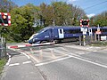 A Javelin leaves the level crossing at Grove Ferry - geograph.org.uk - 4934115.jpg 4,608 × 3,456; 3.48 MB
-
 A28 - geograph.org.uk - 3363991.jpg 640 × 430; 32 KB
-
 A28 approaching Upstreet - geograph.org.uk - 3363994.jpg 640 × 367; 26 KB
-
 A28 to Sarre - geograph.org.uk - 3366896.jpg 640 × 395; 51 KB
-
 A28, entering Upstreet - geograph.org.uk - 3364001.jpg 640 × 430; 36 KB
-
 A28, Island Rd - geograph.org.uk - 3364011.jpg 640 × 430; 51 KB
-
 A28, Sarre Wall - geograph.org.uk - 3364020.jpg 640 × 402; 50 KB
-
 A28, Sarre Wall - geograph.org.uk - 3366893.jpg 640 × 389; 38 KB
-
 A28, Sarre Wall - geograph.org.uk - 3366895.jpg 640 × 395; 52 KB
-
 A28, Upstreet - geograph.org.uk - 3364004.jpg 640 × 430; 45 KB
-
 A28, Upstreet - geograph.org.uk - 3364007.jpg 640 × 430; 56 KB
-
 A28, Upstreet Farm - geograph.org.uk - 3364013.jpg 640 × 430; 42 KB
-
 A299 Thanet Way crosses into Thanet - geograph.org.uk - 5676881.jpg 640 × 480; 112 KB
-
 A299 Thanet Way towards Thanet - geograph.org.uk - 5674817.jpg 640 × 428; 88 KB
-
 A299 towards St. Nicholas at Wade - geograph.org.uk - 2006003.jpg 3,072 × 2,304; 1.46 MB
-
 Alongside Sarre Penn - geograph.org.uk - 3975470.jpg 4,000 × 3,000; 4.31 MB
-
 Alongside Sarre Penn approaching Sarre - geograph.org.uk - 3975519.jpg 4,000 × 3,000; 4.39 MB
-
 An arable landscape - geograph.org.uk - 2810793.jpg 640 × 430; 97 KB
-
 Barn and mobile phone towers near Port Farm - geograph.org.uk - 2132960.jpg 3,072 × 2,304; 1.64 MB
-
 Barn on Island Road, Wall End - geograph.org.uk - 5058896.jpg 2,048 × 1,536; 1.49 MB
-
 Barn, Chislet Court Farm - geograph.org.uk - 2810821.jpg 640 × 430; 66 KB
-
 Bell Court - geograph.org.uk - 2009324.jpg 3,072 × 2,304; 2.05 MB
-
 Bell Court - geograph.org.uk - 5029182.jpg 4,608 × 3,456; 3.58 MB
-
 Bell Court from Reynolds Farm Road - geograph.org.uk - 5029185.jpg 4,608 × 3,456; 3.64 MB
-
 Bend on the River Great Stour - geograph.org.uk - 2129036.jpg 3,072 × 2,304; 2 MB
-
 Bend, A28 - geograph.org.uk - 3364017.jpg 640 × 430; 44 KB
-
 Boats on River Great Stour - geograph.org.uk - 2424671.jpg 3,072 × 2,304; 1.89 MB
-
 Bollingbroke Bridge and Sarre Penn stream - geograph.org.uk - 2007980.jpg 3,072 × 2,304; 2.84 MB
-
 Boyden Gate - geograph.org.uk - 5029193.jpg 4,608 × 3,456; 3.39 MB
-
 Boyden Gate Hill - geograph.org.uk - 5029191.jpg 4,608 × 3,456; 3.41 MB
-
 Bridge and field by North Stream - geograph.org.uk - 3088425.jpg 640 × 480; 108 KB
-
 Bridge over North Stream - geograph.org.uk - 3088095.jpg 640 × 480; 125 KB
-
 Bridge over North Stream - geograph.org.uk - 3088098.jpg 640 × 480; 125 KB
-
 Bridge over Whitfield Sewer at the end of Gilling Drove - geograph.org.uk - 2008262.jpg 2,304 × 3,072; 2.88 MB
-
 Burial ground, Chislet - geograph.org.uk - 2814165.jpg 640 × 430; 86 KB
-
 Bushes by Island Road, Upstreet - geograph.org.uk - 5155838.jpg 1,998 × 1,466; 822 KB
-
 Byway near Boyden Gate - geograph.org.uk - 2009342.jpg 3,072 × 2,304; 2.26 MB
-
 Cattle grazing, Chislet South Level - geograph.org.uk - 4510437.jpg 640 × 480; 132 KB
-
 Chapel Lane - geograph.org.uk - 3088025.jpg 640 × 480; 64 KB
-
 Chislet Beacon - geograph.org.uk - 2009458.jpg 2,304 × 3,072; 1.46 MB
-
 Chislet Burial Ground - geograph.org.uk - 2814168.jpg 640 × 430; 86 KB
-
 Chislet Burial Ground - geograph.org.uk - 2814184.jpg 640 × 430; 69 KB
-
 Chislet Court - geograph.org.uk - 2810839.jpg 640 × 430; 122 KB
-
 Chislet Court Farm - geograph.org.uk - 2810820.jpg 640 × 430; 67 KB
-
 Chislet Court Farm - geograph.org.uk - 2810824.jpg 640 × 430; 69 KB
-
 Chislet Court Farm - geograph.org.uk - 2810828.jpg 640 × 430; 57 KB
-
 Chislet Court Farm - geograph.org.uk - 372382.jpg 640 × 480; 197 KB
-
 Chislet Mock Mill-geograph.org-3089432.jpg 640 × 480; 74 KB
-
 Chislet Primary School - geograph.org.uk - 2814156.jpg 640 × 430; 86 KB
-
 Chislet Primary School - geograph.org.uk - 2814160.jpg 640 × 430; 105 KB
-
 Chislet Primary School - geograph.org.uk - 2814163.jpg 640 × 430; 81 KB
-
 Chislet Village Sign - geograph.org.uk - 2814135.jpg 430 × 640; 88 KB
-
 A Postbox opposite Chislet Church. - geograph.org.uk - 491137.jpg 565 × 640; 212 KB
-
 Chislet, St Mary the Virgin - geograph.org.uk - 4003970.jpg 4,320 × 3,240; 5.72 MB
-
 Chitty Farm near Chislet - geograph.org.uk - 372385.jpg 640 × 480; 237 KB
-
 Chitty Lane - geograph.org.uk - 2008127.jpg 3,072 × 2,304; 2.22 MB
-
 Chitty Lane - geograph.org.uk - 2810813.jpg 640 × 430; 73 KB
-
 Chitty Lane - geograph.org.uk - 3974845.jpg 4,000 × 3,000; 3.91 MB
-
 Chitty Lane leading towards Boyden Gate - geograph.org.uk - 2008156.jpg 3,072 × 2,304; 2.47 MB
-
 Church Cottage - geograph.org.uk - 2814132.jpg 640 × 430; 80 KB
-
 Church Cottage - geograph.org.uk - 2814133.jpg 640 × 430; 97 KB
-
 Church Lane - geograph.org.uk - 1845567.jpg 1,024 × 768; 202 KB
-
 Church Lane - geograph.org.uk - 2806606.jpg 640 × 430; 72 KB
-
 Church Lane - geograph.org.uk - 2806642.jpg 640 × 430; 102 KB
-
 Church Lane - geograph.org.uk - 2806660.jpg 640 × 430; 84 KB
-
 Church Lane - geograph.org.uk - 2806665.jpg 640 × 430; 47 KB
-
 Church Lane heading south - geograph.org.uk - 2810792.jpg 640 × 430; 58 KB
-
 Church Lane, Chitty Lane junction - geograph.org.uk - 2806645.jpg 640 × 430; 54 KB
-
 Circle of trees - geograph.org.uk - 2806664.jpg 640 × 430; 89 KB
-
 Closed, the Hog and Donkey - geograph.org.uk - 1192623.jpg 480 × 640; 160 KB
-
 Cornfield by Wantsum Walk - geograph.org.uk - 3089402.jpg 640 × 480; 130 KB
-
 Cottage door - geograph.org.uk - 491190.jpg 428 × 640; 160 KB
-
 Cottages at Chitty - geograph.org.uk - 3974860.jpg 4,000 × 3,000; 4.06 MB
-
 Cottages in Chislet - geograph.org.uk - 2810843.jpg 640 × 430; 44 KB
-
 Cropland, Church Lane - geograph.org.uk - 2806652.jpg 640 × 430; 61 KB
-
 Cropland, Church Lane - geograph.org.uk - 2806662.jpg 640 × 430; 98 KB
-
 Crops north of Chislet - geograph.org.uk - 2810790.jpg 640 × 430; 92 KB
-
 Drain by Chitty Lane - geograph.org.uk - 4510500.jpg 640 × 480; 157 KB
-
 Drain in Chislet Marshes (2) - geograph.org.uk - 2008242.jpg 3,072 × 2,304; 2.85 MB
-
 Drain in Chislet Marshes (3) - geograph.org.uk - 2008252.jpg 3,072 × 2,304; 2.02 MB
-
 Drain in Chislet Marshes - geograph.org.uk - 2008165.jpg 3,072 × 2,304; 3.24 MB
-
 Drain in the Wade Marshes - geograph.org.uk - 2008013.jpg 3,072 × 2,304; 2.65 MB
-
 Drain in the Wade marshes - geograph.org.uk - 2008060.jpg 3,072 × 2,304; 2.56 MB
-
 Drain junction near Sarre - geograph.org.uk - 2008004.jpg 3,072 × 2,304; 2.41 MB
-
 Drain near Little Grays Farm - geograph.org.uk - 2009273.jpg 3,072 × 2,304; 2.91 MB
-
 Drain towards Wall End Farm - geograph.org.uk - 2008097.jpg 3,072 × 2,304; 2.53 MB
-
 Drainage channel beside the Nethergong Penn - geograph.org.uk - 1960216.jpg 2,304 × 3,072; 2.7 MB
-
 Electricity cables above Island Road, Sarre - geograph.org.uk - 5058123.jpg 2,048 × 1,536; 1.51 MB
-
 Entering Chislet - geograph.org.uk - 2810795.jpg 640 × 430; 75 KB
-
 Entering Chislet - geograph.org.uk - 2814176.jpg 640 × 430; 105 KB
-
-
 Exit from the Thanet Way to Marshside - geograph.org.uk - 383345.jpg 640 × 480; 29 KB
-
 Fallen tree - geograph.org.uk - 2816562.jpg 640 × 430; 143 KB
-
 Farm bridge over a drain near the Sarre Penn - geograph.org.uk - 2008050.jpg 3,072 × 2,304; 2.34 MB
-
 Farm bridge over the Sarre Penn stream - geograph.org.uk - 2008107.jpg 3,072 × 2,304; 1.58 MB
-
 Farm road and bridleway - geograph.org.uk - 385324.jpg 640 × 480; 59 KB
-
 Farm track and public footpath - geograph.org.uk - 4510487.jpg 640 × 480; 102 KB
-
 Farm track off Chitty Lane - geograph.org.uk - 4510470.jpg 640 × 480; 113 KB
-
 Farmers Footbridge near the Whitfield Sewer - geograph.org.uk - 2008317.jpg 3,072 × 2,304; 3.28 MB
-
 Farmland by Church Lane - geograph.org.uk - 2810787.jpg 640 × 430; 90 KB
-

-
 Farmland near Nethergong Penn - geograph.org.uk - 2816527.jpg 640 × 430; 67 KB
-
 Farmland near Nethergong Penn - geograph.org.uk - 2820016.jpg 640 × 430; 64 KB
-
 Farmland near Nethergong Penn - geograph.org.uk - 2820039.jpg 640 × 430; 79 KB
-
 Farmland north of Chislet - geograph.org.uk - 2810789.jpg 640 × 430; 75 KB
-
 Field beside the A28 Island Road - geograph.org.uk - 2132971.jpg 3,072 × 2,304; 1.63 MB
-
 Field by Chapel Lane - geograph.org.uk - 3088026.jpg 640 × 480; 78 KB
-
 Field by Island Road, Sarre - geograph.org.uk - 5155823.jpg 2,048 × 1,536; 1.49 MB
-
 Field ditch in Chislet Marshes - geograph.org.uk - 2438865.jpg 3,072 × 2,304; 1.83 MB
-
 Field Drain towards Puddledock Wood - geograph.org.uk - 2438872.jpg 3,072 × 2,304; 1.66 MB
-
 Fields by Island Road, Upstreet - geograph.org.uk - 5155837.jpg 2,020 × 1,364; 633 KB
-
 Fields near Wantsum Walk - geograph.org.uk - 3095401.jpg 640 × 427; 87 KB
-
 Fields south of Chislet - geograph.org.uk - 2814151.jpg 640 × 430; 60 KB
-
 Fields west of Chislet - geograph.org.uk - 2814182.jpg 640 × 430; 58 KB
-
 Fishing in the River Great Stour - geograph.org.uk - 2129060.jpg 3,072 × 2,304; 2.16 MB
-
 Footbridge near Little Grays Farm - geograph.org.uk - 2009291.jpg 3,072 × 2,304; 1.81 MB
-
 Footbridge over a drain near Whitfield Sewer - geograph.org.uk - 2008033.jpg 3,072 × 2,304; 2.72 MB
-
 Footbridge over the Nethergong Penn - geograph.org.uk - 1960208.jpg 2,304 × 3,072; 2.67 MB
-
 Footbridge over Whitfield Sewer - geograph.org.uk - 3088014.jpg 640 × 480; 115 KB
-
 Footbridge over Whitfield Sewer - geograph.org.uk - 3088016.jpg 640 × 480; 101 KB
-
 Footbridge over Whitfield Sewer - geograph.org.uk - 3088089.jpg 640 × 480; 117 KB
-
 Footbridge over Whitfield Sewer - geograph.org.uk - 3088423.jpg 480 × 640; 154 KB
-
 Footbridge over Whitfield Sewer - geograph.org.uk - 3088433.jpg 480 × 640; 162 KB
-
 Footbridge, Nethergong Penn - geograph.org.uk - 2819976.jpg 640 × 430; 83 KB
-
 Footbridge, Whitfield Sewer - geograph.org.uk - 3089417.jpg 640 × 480; 114 KB
-
 Footpath across the fields - geograph.org.uk - 2816499.jpg 640 × 430; 34 KB
-
 Footpath along the Nethergong Valley - geograph.org.uk - 2820152.jpg 640 × 430; 84 KB
-
 Footpath along the Nethergong Valley - geograph.org.uk - 2820176.jpg 640 × 430; 71 KB
-
 Footpath beside the Sarre Penn - geograph.org.uk - 2008064.jpg 3,072 × 2,304; 2.41 MB
-
 Footpath from Little Grays Farm - geograph.org.uk - 2438915.jpg 3,072 × 2,304; 2.26 MB
-
 Footpath in Chislet, Kent.jpg 426 × 640; 100 KB
-
 Footpath in the Nethergong Valley - geograph.org.uk - 2820167.jpg 640 × 430; 64 KB
-
 Footpath junction near Boyden Gate - geograph.org.uk - 2009355.jpg 3,072 × 2,304; 2.31 MB
-
 Footpath junction on the byway near Midway Farm - geograph.org.uk - 2009347.jpg 3,072 × 2,304; 2.56 MB
-
 Footpath off Church Lane - geograph.org.uk - 2806612.jpg 640 × 430; 115 KB
-
 Footpath off Hollow Street - geograph.org.uk - 2816516.jpg 640 × 430; 84 KB
-
 Footpath off the A28 near Upstreet - geograph.org.uk - 3070011.jpg 3,872 × 2,592; 4.2 MB
-
 Footpath on Island Road - geograph.org.uk - 2132966.jpg 3,072 × 1,728; 1.46 MB
-
 Footpath to Chitty - geograph.org.uk - 2008036.jpg 3,072 × 2,304; 3.31 MB
-
 Footpath to Nethergong Penn - geograph.org.uk - 2816521.jpg 640 × 430; 139 KB
-
 Footpath to Nethergong Penn - geograph.org.uk - 2816523.jpg 640 × 430; 125 KB
-
 Footpath to Sarre - geograph.org.uk - 2008079.jpg 3,072 × 2,304; 2.29 MB
-
 Footpath to Sarre - geograph.org.uk - 3974869.jpg 4,000 × 3,000; 3.91 MB
-
 Footpath to the Chislet Marshes - geograph.org.uk - 2008137.jpg 3,072 × 2,304; 2 MB
-
 Footpath towards Island Road - geograph.org.uk - 1960214.jpg 3,072 × 2,304; 2.08 MB
-
 Footpath towards Little Grays Farm - geograph.org.uk - 2008296.jpg 3,072 × 2,304; 3.07 MB
-
 Footpath towards Little Grays Farm - geograph.org.uk - 2009299.jpg 3,072 × 2,304; 2.12 MB
-
 Footpath towards Little Grays Farm - geograph.org.uk - 2438908.jpg 3,072 × 2,304; 2.03 MB
-
 Footpath towards Nethergong Penn (2) - geograph.org.uk - 1960197.jpg 3,072 × 2,304; 1.93 MB
-
 Footpath towards Puddledock Wood - geograph.org.uk - 1961290.jpg 3,072 × 2,304; 1.16 MB
-
 Footpath towards Sarre - geograph.org.uk - 2008101.jpg 3,072 × 2,304; 1.98 MB
-
 Footpath towards the Nethergong Penn - geograph.org.uk - 1960193.jpg 3,072 × 2,304; 1.62 MB
-
 Footpath towards Upstreet - geograph.org.uk - 2008068.jpg 3,072 × 2,304; 2.27 MB
-
 Former footpath alongside Sarre Penn - geograph.org.uk - 3975477.jpg 4,000 × 3,000; 4.08 MB
-
 Former footpath at Sarre - geograph.org.uk - 3975508.jpg 4,000 × 3,000; 4.2 MB
-
 Former Public House, Chislet - geograph.org.uk - 2810819.jpg 640 × 430; 85 KB
-
 Fruit store by Poachers End - geograph.org.uk - 3087913.jpg 640 × 251; 44 KB
-
 Garage in Upstreet - geograph.org.uk - 3070019.jpg 3,872 × 2,592; 4.3 MB
-
 Gate beside the Nethergong Penn - geograph.org.uk - 1960206.jpg 3,072 × 2,304; 1.77 MB
-
 Gate near Whitfield Sewer - geograph.org.uk - 2008026.jpg 3,072 × 2,304; 2.45 MB
-
 Gilling Drove - geograph.org.uk - 2008147.jpg 3,072 × 2,304; 2.99 MB
-
 Gilling Drove - geograph.org.uk - 3974815.jpg 4,000 × 3,000; 3.99 MB
-
 Gilling Drove - geograph.org.uk - 3974826.jpg 4,000 × 3,000; 4.02 MB
-
 Gilling Drove towards Chitty Lane - geograph.org.uk - 2008190.jpg 3,072 × 2,304; 2.17 MB
-
 Gilling Drove towards the Chislet Marshes - geograph.org.uk - 2008178.jpg 3,072 × 2,304; 2.55 MB
-
 Great Stour - geograph.org.uk - 4372086.jpg 640 × 428; 73 KB
-
 Great Stour at Grove Ferry - geograph.org.uk - 4510371.jpg 640 × 480; 168 KB
-
 Heart in Hand Road, Broomfield - geograph.org.uk - 5840185.jpg 2,048 × 1,536; 1.77 MB
-
 Hollow Rd, Chislet - geograph.org.uk - 2810814.jpg 640 × 430; 52 KB
-
 Hollow Street - geograph.org.uk - 2816504.jpg 640 × 430; 54 KB
-
 Hollow Street - geograph.org.uk - 2816510.jpg 631 × 640; 77 KB
-
 Hollow Street - geograph.org.uk - 2816518.jpg 640 × 430; 62 KB
-
 Hollow Street Cottages - geograph.org.uk - 2816508.jpg 640 × 430; 84 KB
-
 Hollow Street House - geograph.org.uk - 2816502.jpg 640 × 430; 98 KB
-
 House on Church Lane - geograph.org.uk - 2810810.jpg 640 × 430; 75 KB
-
 House on Forge Lane - geograph.org.uk - 2806627.jpg 640 × 430; 71 KB
-
 Houses on Church Lane, Boyden Gate - geograph.org.uk - 2806629.jpg 640 × 430; 62 KB
-
 In the Nethergong Penn Valley - geograph.org.uk - 2820019.jpg 640 × 430; 65 KB
-
 Island Rd, A28 - geograph.org.uk - 3363988.jpg 640 × 391; 27 KB
-
 Island Rd, A28 - geograph.org.uk - 3364015.jpg 640 × 430; 30 KB
-
 Island Road - geograph.org.uk - 1845678.jpg 1,024 × 683; 170 KB
-
 Island Road near Hersden - geograph.org.uk - 3070006.jpg 3,872 × 2,592; 3.51 MB
-
 Island Road, Sarre - geograph.org.uk - 5155824.jpg 2,048 × 1,536; 1.52 MB
-
 Island Road, Upstreet - geograph.org.uk - 3724426.jpg 640 × 480; 286 KB
-
 Island Road, Wall End - geograph.org.uk - 3724319.jpg 640 × 480; 266 KB
-

-
 K6 telephone box under renovation, North Stream - geograph.org.uk - 6109752.jpg 4,701 × 3,134; 1.33 MB
-
 Keel Farm - geograph.org.uk - 2009313.jpg 3,072 × 2,304; 2.23 MB
-
 Kosi Kot, Boyden Gate - geograph.org.uk - 2806600.jpg 640 × 430; 75 KB
-
 Late afternoon view from Island Road - geograph.org.uk - 2132968.jpg 3,072 × 1,728; 1.25 MB
-
 Layby on Island Road, Sarre - geograph.org.uk - 5155821.jpg 2,048 × 1,536; 1.52 MB
-
 Layby on Island Road, Sarre - geograph.org.uk - 5159046.jpg 2,048 × 1,536; 1.17 MB
-
 Layby on Thanet Way, Grays - geograph.org.uk - 5840184.jpg 1,878 × 1,284; 1,008 KB
-
 Layby, Island Road (A28) - geograph.org.uk - 5833286.jpg 3,264 × 2,448; 2.1 MB
-
 Level crossing at Grove Ferry - geograph.org.uk - 4934107.jpg 4,608 × 3,456; 3.37 MB
-
 Level crossing in Grove Ferry - geograph.org.uk - 5058080.jpg 2,048 × 1,536; 1.6 MB


_-_geograph.org.uk_-_2008242.jpg)
_-_geograph.org.uk_-_2008252.jpg)


_-_geograph.org.uk_-_1960197.jpg)


_-_geograph.org.uk_-_5833286.jpg)

