Category:Châtillon (summit)
Jump to navigation
Jump to search
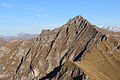
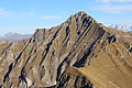
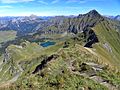
Français : Le Châtillon est un sommet des Préalpes vaudoises situé en Suisse, dans le canton de Vaud.
| Object location | | View all coordinates using: OpenStreetMap |
|---|
mountain in the Vaud Prealps, Switzerland  | |||||
| Upload media | |||||
| Instance of | |||||
|---|---|---|---|---|---|
| Part of |
| ||||
| Location | |||||
| Mountain range | |||||
| Elevation above sea level |
| ||||
 | |||||
Media in category "Châtillon (summit)"
The following 12 files are in this category, out of 12 total.
-
 Châtillon (15515619308).jpg 5,184 × 3,456; 8.66 MB
-
 Châtillon (15516197350).jpg 5,184 × 3,456; 7.03 MB
-
 Châtillon (15532340808).jpg 5,184 × 3,456; 8.44 MB
-
 Châtillon (15713578701).jpg 5,184 × 3,456; 9 MB
-
 Glacier 3000 in Verbier, Switzerland.jpg 2,592 × 1,944; 1.81 MB
-
 Le Châtillon, end of March.jpg 2,816 × 2,112; 1.57 MB
-
 Les Diablerets (1).jpg 2,304 × 1,728; 1.34 MB
-
 Panoramic view from the Pic Chaussy (15546119410).jpg 18,046 × 4,396; 79.75 MB
-
 Panoramic view from the Pic Chaussy (15546249817).jpg 17,601 × 4,566; 91.23 MB
-
 Panoramic view from the Pic Chaussy (15701633876).jpg 11,791 × 4,078; 56.49 MB
-
 Pic Chaussy - Vue sur Liozon.jpg 2,048 × 1,536; 891 KB
-
 Pic Chaussy, Le Tarent and La Para (30884982018).jpg 5,184 × 3,456; 5.09 MB
.jpg)
.jpg)
.jpg)
.jpg)

.jpg)

.jpg)
.jpg)
.jpg)
.jpg)