Category:Càrn a' Mhàim
Jump to navigation
Jump to search
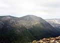
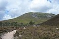
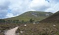
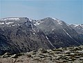
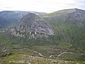
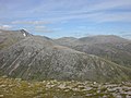
Càrn a' Mhàim is a mountain situated in the inner part of the Cairngorms range in Scotland, some 15 kilometres west of Braemar in the county of Aberdeenshire.
Scottish mountain situated in the inner part of the Cairngorms range  | |||||
| Upload media | |||||
| Instance of | |||||
|---|---|---|---|---|---|
| Location | Aberdeenshire, Scotland | ||||
| Mountain range | |||||
| Topographic prominence |
| ||||
| Elevation above sea level |
| ||||
| Parent peak | |||||
 | |||||
Media in category "Càrn a' Mhàim"
The following 26 files are in this category, out of 26 total.
-

-
 Cairn Toul from Carn a'Mhaim.jpg 1,980 × 1,416; 269 KB
-
 Carn a Mhaim - geograph.org.uk - 266031.jpg 640 × 480; 82 KB
-
-
-
 Carn a' Mhaim , Munro No 95 - geograph.org.uk - 72944.jpg 640 × 480; 220 KB
-
 Carn a' Mhaim - geograph.org.uk - 1142257.jpg 640 × 410; 65 KB
-
 Carn a' Mhaim - geograph.org.uk - 1145652.jpg 640 × 493; 97 KB
-
 Carn a' Mhaim - geograph.org.uk - 133986.jpg 640 × 480; 38 KB
-
 Carn a' Mhaim - geograph.org.uk - 230938.jpg 640 × 480; 65 KB
-
 Carn a' Mhaim - geograph.org.uk - 783422.jpg 640 × 360; 63 KB
-
 Carn a' Mhaim - North Ridge - geograph.org.uk - 567201.jpg 480 × 640; 68 KB
-
 Carn a' Mhaim from Ben Macdhui.jpg 1,998 × 1,391; 86 KB
-
 Carn a' Mhaim, southeast ridge - geograph.org.uk - 133436.jpg 480 × 640; 99 KB
-
 Carn a' Mhaim, southeast top - geograph.org.uk - 133440.jpg 480 × 640; 68 KB
-
 Derry Cairngorm from Carn a Mhaim.jpg 1,752 × 1,246; 72 KB
-
 Devil's Point from Carn a' Mhaim - geograph.org.uk - 230936.jpg 640 × 480; 80 KB
-
 Glen Lui - geograph.org.uk - 7578.jpg 640 × 480; 87 KB
-
 Lairig-ghru-sketch-map.jpg 600 × 881; 51 KB
-
 Leaving the summit - geograph.org.uk - 133989.jpg 640 × 480; 39 KB
-
 Mountain Footpath Work - geograph.org.uk - 567179.jpg 640 × 480; 94 KB
-
 The Lairig Ghru - geograph.org.uk - 24077.jpg 640 × 480; 219 KB
-
 View north east from Carn a' Mhaim - geograph.org.uk - 595669.jpg 800 × 600; 145 KB
-
 View west from Carn a' Mhaim - geograph.org.uk - 641776.jpg 800 × 544; 135 KB
-
 Carn a' Mhaim North Ridge - geograph.org.uk - 229147.jpg 640 × 480; 71 KB
-
 Descending towards Glen Luibeg - geograph.org.uk - 133991.jpg 640 × 480; 113 KB


.jpg)


