Category:Butzensee (Vorarlberg)
Jump to navigation
Jump to search
lake in Schröcken, Vorarlberg, Austria   | |||||
| Upload media | |||||
| Instance of | |||||
|---|---|---|---|---|---|
| Location | Schröcken, Bregenz District, Vorarlberg, Austria | ||||
| Area |
| ||||
| Elevation above sea level |
| ||||
 | |||||
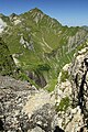
Deutsch: Der Butzensee liegt auf 2.124 Meter Höhe ü. A. am Fuße der Mohnenfluh. Er ist kristallklar und wird als biologisch tot bezeichnet, weil er mehr als 2/3 des Jahres zugefroren ist.
Subcategories
This category has only the following subcategory.
G
- Geislinger Steig, Jägersteig (6 F)
Media in category "Butzensee (Vorarlberg)"
The following 13 files are in this category, out of 13 total.
-
 360° Mohnenfluh Oberlech Panorama.jpg 7,331 × 2,578; 12.33 MB
-
 Butzensee Bergpanorama.jpg 5,184 × 3,456; 7.28 MB
-
 Butzensee Butzen Spitze, Panorama.jpg 5,694 × 2,655; 2.64 MB
-
 Butzensee Butzen Spitze.JPG 4,110 × 2,846; 6.87 MB
-
 Butzensee Hochberg.JPG 4,110 × 2,846; 6.35 MB
-
 Butzensee Mohnenfluh, Panorama.jpg 4,503 × 3,546; 3.38 MB
-
 Butzensee.jpg 6,782 × 5,084; 13.09 MB
-
 Butzenspitze 2547m Panorama.jpg 4,729 × 2,328; 2.37 MB
-
 Geislinger, Jäger Steig Wasserrinne 1.JPG 2,848 × 4,272; 10.49 MB
-
 Mohnenfluhsattel Panorama.jpg 8,649 × 2,054; 13.84 MB
-
 Panorama Butzensee.jpg 13,397 × 5,969; 60.51 MB
-
 Schröcken Butzensee Schrägluftbild.jpg 5,000 × 3,333; 17.24 MB
-
 Thomas Praßler Weg Butzenspitze.jpg 7,807 × 2,127; 4.29 MB


