Category:Burgruine Hörtenberg
Jump to navigation
Jump to search
| Object location | | View all coordinates using: OpenStreetMap |
|---|
| This category shows the protected monument with the number 122329 in Austria. (Commons, de, Wikidata) |
building in Pfaffenhofen, Austria  | |||||
| Upload media | |||||
| Instance of | |||||
|---|---|---|---|---|---|
| Location | Pfaffenhofen, Innsbruck-Land District, Tyrol, Austria | ||||
| Heritage designation | |||||
 | |||||
Media in category "Burgruine Hörtenberg"
The following 6 files are in this category, out of 6 total.
-
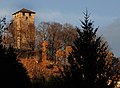 "Burg Hörtenberg" - Pfaffenhofen.jpg 1,850 × 1,350; 847 KB
-
 "Burg Hörtenberg"2 - Pfaffenhofen.jpg 2,240 × 1,488; 672 KB
-
 Arlbergbahn km025p5 volare o 30013 3000px.jpg 2,541 × 1,699; 1.02 MB
-
 Bergseite der Burgruine Hörtenberg, Blick talwärts auf die Stadt Telfs.jpg 2,200 × 3,301; 2.5 MB
-
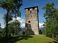 Burgruine Hörtenberg Westen 01.jpg 4,160 × 3,120; 4.34 MB
-
 Burgruine Hörtenberg Westen 02.jpg 3,120 × 4,160; 4.05 MB


