Category:Bridge 17, Macclesfield Canal
Jump to navigation
Jump to search
| Object location | | View all coordinates using: OpenStreetMap |
|---|
Grade II listed canal bridge in the parish of Pott Shrigley, Cheshire East, Cheshire, UK  | |||||
| Upload media | |||||
| Instance of | |||||
|---|---|---|---|---|---|
| Location | Pott Shrigley, Cheshire East, Cheshire, North West England, England | ||||
| Crosses |
| ||||
| Heritage designation |
| ||||
 | |||||
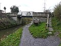
Wooden beam bridge carrying footpath Simpson Lane over the Macclesfield Canal, Pott Shrigley, Cheshire East, Cheshire, England.
Bridge number 17 over the Macclesfield Canal.
Media in category "Bridge 17, Macclesfield Canal"
The following 8 files are in this category, out of 8 total.
-
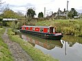 Bridge 17 on Macclesfield Canal, with barge - geograph.org.uk - 3231591.jpg 4,000 × 3,000; 2.33 MB
-
 Bridge 17 on the Macclesfield Canal - geograph.org.uk - 3020548.jpg 3,872 × 2,592; 5.16 MB
-
 Bridge 17 on the Macclesfield Canal - geograph.org.uk - 3221403.jpg 800 × 533; 129 KB
-
 Bridge 17, Macclesfield Canal 01.jpg 4,000 × 3,000; 6.22 MB
-
 Bridge 17, Macclesfield Canal 02.jpg 4,000 × 3,000; 6.44 MB
-
 Bridge 17, Macclesfield Canal 03.jpg 4,000 × 3,000; 6.27 MB
-

-


