Category:Battle Mountain (Virginia)
Jump to navigation
Jump to search
Media in category "Battle Mountain (Virginia)"
The following 11 files are in this category, out of 11 total.
-
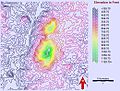 Battle Mountain countour map based on NASA ASTER data.jpg 520 × 393; 150 KB
-
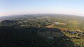
 Battle Mountain from-8-miles-south Culpeper County.jpg 2,560 × 1,920; 1.37 MB
-
 BattleMountain PaleaogeographicReconstruction 704Mya.jpg 923 × 942; 138 KB
-
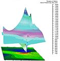
 Digital terrain model of Battle Mountain based on ASTER data.png 1,217 × 752; 217 KB
-
 Eastern side of Battle Mountain in Amissville Virginia.jpg 4,384 × 2,466; 2.22 MB
-
 Eastern slope Battle Mountain 1km.jpg 3,648 × 2,736; 2.01 MB
-
 Large Quartz Boulder from Battle Mountain.jpg 3,648 × 2,736; 2.11 MB
-
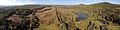 Moutains at Amissville.jpg 9,084 × 2,308; 6.57 MB
-
 Quartz boulder obtained from Battle Mountain, Amissville Virginia.png 5,312 × 2,988; 20.61 MB
-

-
 Western slope Battle Mountain.jpg 4,384 × 2,466; 3.55 MB


