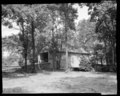
Category:Ashland Covered Bridge
Jump to navigation
Jump to search
|
This is a category about a place or building that is listed on the National Register of Historic Places in the United States of America. Its reference number is 73000506. |
| Object location | | View all coordinates using: OpenStreetMap |
|---|
United States historic place  | |||||
| Upload media | |||||
| Instance of | |||||
|---|---|---|---|---|---|
| Location | Ashland, Delaware | ||||
| Crosses |
| ||||
| Heritage designation |
| ||||
| Inception |
| ||||
| Length |
| ||||
 | |||||
Media in category "Ashland Covered Bridge"
The following 7 files are in this category, out of 7 total.
-
 Ashland Bridge Delaware 2015.JPG 4,608 × 3,072; 6.54 MB
-
 ASHLAND C.B., NEW CASTLE COUNTY, DELAWARE.jpg 5,262 × 3,500; 4.26 MB
-

-
 ASHLAND COVERED BRIDGE, NEW CASTLE COUNTY, DELAWARE.jpg 5,253 × 3,475; 4.73 MB
-

-
-


.jpg)
