Category:Aerial photographs of Peoria, Illinois
Jump to navigation
Jump to search
Media in category "Aerial photographs of Peoria, Illinois"
The following 20 files are in this category, out of 20 total.
-

-

-
 Bradley U Campus Aerial.jpg 1,024 × 620; 258 KB
-
 Bradley University Aerial Photo.jpg 1,280 × 778; 359 KB
-
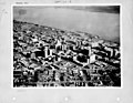
 Downtown Peoria from Air 1971.jpg 1,150 × 756; 567 KB
-
 IL Peoria June 1911.jpg 3,566 × 420; 561 KB
-
 Illinois - Peoria - NARA - 23939929.jpg 4,385 × 3,382; 3.48 MB
-
 Illinois - Peoria - NARA - 23939931.jpg 4,385 × 3,382; 3.24 MB
-
 Illinois - Peoria - NARA - 23939933.jpg 4,385 × 3,382; 2.64 MB
-
 Lutheran Hillside Village aerial view.jpg 3,342 × 1,212; 1.67 MB
-
 Northwest Peoria from Air 1974 Northwoods Mall I-74 & US 150.jpg 1,100 × 735; 553 KB
-
 Peoria - Glen Avenue from the Air 1974.jpg 1,200 × 804; 540 KB
-
 Peoria Aerial - Facing North (42241118264).jpg 2,400 × 1,600; 2.24 MB
-
 Peoria Aerial - Facing Northwest (42058196655).jpg 2,400 × 1,600; 2.19 MB
-
 Peoria Aerial - Facing West (42058196825).jpg 2,400 × 1,600; 2.28 MB
-
 Peoria and Illinois River from Air 1974.jpg 1,250 × 729; 553 KB
-
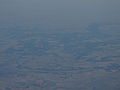
 Peoria from the Air over Tazewell County 1977.jpg 1,200 × 667; 307 KB
-
 Peoria, Illinois (7235200280).jpg 4,000 × 3,000; 1.95 MB
-
 Peoria, Illinois, mid-20th century (NBY 3079).jpg 3,600 × 2,911; 1.46 MB
-
 Taft Homes Peoria.JPG 434 × 403; 37 KB


.jpg)
.jpg)
.jpg)


.jpg)
.jpg)
