Category:A82 road (Scotland)
Jump to navigation
Jump to search
Deutsch: Die A82 road ist eine A-Straße in Schottland. Sie verläuft von Glasgow über Fort William nach Inverness und stellt eine der wichtigsten Straßenverbindungen in die westlichen Highlands dar.
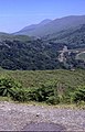
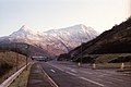
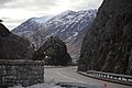
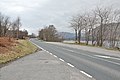
English: The A82 is a road in Scotland that runs from Glasgow to Inverness by way of Fort William. The majority of the route is a trunk road and hence managed by Transport Scotland, who view the road as a vitally important link through the Scottish Highlands and beyond.
Gàidhlig: Tha am mór-rathad an A82 a’ dol bho Glaschu tron Ghearasdan gu Inbhir Nis, astar 269 km (167 mìle).
Polski: Droga A82 − trasa tranzytowa w Szkocji biegnąca z Glasgow do Inverness przez Fort William. Jej długość to 269 km.
Scots: The A82 is a road in Scotland that runs frae Glesga tae Inverness bi way o Fort William. The majority o the route is a trunk road an hence managed bi Transport Scotland, who view the road as a vitally important link through the Scots Hielands an beyond.

A road in Scotland from Glasgow to Inverness via Fort William    | |||||
| Upload media | |||||
| Instance of | |||||
|---|---|---|---|---|---|
| Location | |||||
| Transport network |
| ||||
| Has part(s) |
| ||||
| Length |
| ||||
 | |||||
Subcategories
This category has the following 15 subcategories, out of 15 total.
A
- A82 Bridge over Water of Tulla (14 F)
- Aberchalder Swing Bridge (21 F)
B
- Ballachulish Bridge (49 F)
- Brachla AA box 631 (4 F)
- Burnbrae Tunnel (3 F)
D
- Dumbarton Road, Milton (2 F)
- Duntocher footbridge (2 F)
F
- Fort Augustus Swing Bridge (37 F)
- Friars' Bridge (22 F)
G
I
- Invermoriston Road Bridge (11 F)
L
- Laggan Swing Bridge (19 F)
O
- Overton Road bridge (2 F)
T
- Tomnahurich Bridge (34 F)
Media in category "A82 road (Scotland)"
The following 200 files are in this category, out of 340 total.
(previous page) (next page)-
 360 1096 Stitch XHC.jpg 7,776 × 3,888; 5.2 MB
-
 A 82 - geograph.org.uk - 2505515.jpg 2,555 × 1,742; 347 KB
-
 A 82 road, Glen Coe - geograph.org.uk - 870078.jpg 640 × 493; 115 KB
-
 A major cutting on the A82 by Loch Ness - geograph.org.uk - 2824739.jpg 1,600 × 1,200; 327 KB
-
 A very necessary warning on the A82 - geograph.org.uk - 3637235.jpg 1,024 × 682; 129 KB
-
 A very wet A82 at Bridge of Orchy - geograph.org.uk - 784522.jpg 640 × 426; 59 KB
-
 A817 to A82 Road Junction - geograph.org.uk - 367390.jpg 600 × 450; 150 KB
-
 A82 - geograph.org.uk - 2754.jpg 640 × 446; 30 KB
-
 A82 - geograph.org.uk - 2975939.jpg 2,560 × 1,920; 2.09 MB
-
 A82 - geograph.org.uk - 3099542.jpg 640 × 430; 45 KB
-
 A82 - geograph.org.uk - 3100057.jpg 640 × 430; 80 KB
-
 A82 - geograph.org.uk - 3107143.jpg 640 × 499; 61 KB
-
 A82 - geograph.org.uk - 3107148.jpg 640 × 430; 53 KB
-
 A82 - Longman Roundabout (8463745652).jpg 1,280 × 960; 136 KB
-
 A82 - Longman Roundabout (8463745824).jpg 1,280 × 960; 129 KB
-
 A82 - Spean Bridge, Scotland, UK - May 14, 1989.jpg 5,000 × 7,500; 23.78 MB
-
 A82 along the shore of Loch Lochy - geograph.org.uk - 2145900.jpg 800 × 531; 175 KB
-
 A82 along the shore of Loch Lochy - geograph.org.uk - 2145902.jpg 800 × 531; 169 KB
-
 A82 and lay-by - geograph.org.uk - 4245749.jpg 640 × 398; 55 KB
-
 A82 and Pylon - geograph.org.uk - 4251829.jpg 640 × 456; 39 KB
-
 A82 and the Blackmount hills - geograph.org.uk - 2139725.jpg 800 × 530; 99 KB
-
 A82 and the entrance to Coruanan Lodge - geograph.org.uk - 1767445.jpg 800 × 531; 143 KB
-
 A82 and the John Cobb Memorial - geograph.org.uk - 2157963.jpg 800 × 531; 197 KB
-
 A82 approaches the Pass of Glen Coe - geograph.org.uk - 1511754.jpg 640 × 480; 129 KB
-

-
 A82 approaching Crianlarich - geograph.org.uk - 3501327.jpg 1,024 × 682; 106 KB
-
 A82 approaching Fort William - geograph.org.uk - 3107127.jpg 640 × 348; 48 KB
-
 A82 approaching Fort William - geograph.org.uk - 3224338.jpg 1,200 × 797; 519 KB
-

-
 A82 approaching Townend roundabout - geograph.org.uk - 4447087.jpg 530 × 336; 60 KB
-
 A82 approaching Tyndrum - geograph.org.uk - 3131638.jpg 640 × 451; 68 KB
-
 A82 at Altrua - geograph.org.uk - 2145854.jpg 800 × 531; 275 KB
-
 A82 at Corrychurrachan - geograph.org.uk - 1767530.jpg 800 × 531; 189 KB
-
 A82 at Corrychurrachan - geograph.org.uk - 1767537.jpg 800 × 531; 154 KB
-
 A82 at Drumnadrochit - geograph.org.uk - 4565194.jpg 640 × 480; 85 KB
-
 A82 at Drumnadrochit - geograph.org.uk - 4565217.jpg 640 × 480; 66 KB
-
 A82 at Invergloy Halt - geograph.org.uk - 2145932.jpg 800 × 531; 265 KB
-
 A82 at Invergloy Halt - geograph.org.uk - 2145951.jpg 800 × 531; 284 KB
-
 A82 at the north end of Loch Lochy - geograph.org.uk - 2145871.jpg 800 × 531; 183 KB
-
 A82 at the north end of Loch Lochy - geograph.org.uk - 2145874.jpg 800 × 531; 201 KB
-
 A82 at the north end of Loch Lochy - geograph.org.uk - 2145877.jpg 800 × 531; 236 KB
-
 A82 at the north end of Loch Lochy - geograph.org.uk - 2145878.jpg 800 × 531; 232 KB
-
 A82 at Torvean - geograph.org.uk - 2017741.jpg 800 × 531; 180 KB
-
 A82 between Invermoriston and Fort Augustus - geograph.org.uk - 3105665.jpg 1,200 × 797; 606 KB
-
 A82 by Loch Linnhe - geograph.org.uk - 3100064.jpg 640 × 430; 67 KB
-
 A82 by Loch Linnhe - geograph.org.uk - 3100078.jpg 640 × 392; 73 KB
-
 A82 by Loch Linnhe - geograph.org.uk - 3104221.jpg 640 × 370; 64 KB
-
 A82 climbs north from Tyndrum - geograph.org.uk - 2512627.jpg 1,024 × 736; 118 KB
-
 A82 crosses the River Kiachnish - geograph.org.uk - 3104206.jpg 640 × 335; 40 KB
-
 A82 Crosses the Water of Tulla - geograph.org.uk - 948371.jpg 640 × 418; 58 KB
-
 A82 crossing Rannoch Moor - geograph.org.uk - 2045422.jpg 800 × 531; 187 KB
-
 A82 crossing the River Fillan - geograph.org.uk - 3131623.jpg 640 × 474; 65 KB
-

-
 A82 from Fort William to Spean Bridge - geograph.org.uk - 2146003.jpg 800 × 531; 222 KB
-
 A82 from Spean Bridge to Fort William - geograph.org.uk - 2145999.jpg 800 × 531; 233 KB
-
 A82 from the roundabout - geograph.org.uk - 2282312.jpg 1,024 × 736; 134 KB
-
 A82 Glen Coe - the narrow bit - geograph.org.uk - 2955616.jpg 1,200 × 803; 399 KB
-
 A82 Glen Falloch - geograph.org.uk - 3277911.jpg 1,600 × 1,200; 504 KB
-
 A82 Glen Falloch road - geograph.org.uk - 142861.jpg 640 × 480; 101 KB
-
 A82 heading for Tyndrum - geograph.org.uk - 4245913.jpg 640 × 395; 38 KB
-

-
 A82 Henderson Road junction (8462646335).jpg 1,280 × 748; 86 KB
-
 A82 Henderson Road junction (8463745944).jpg 1,280 × 753; 96 KB
-
 A82 in Glen Falloch - geograph.org.uk - 85656.jpg 411 × 640; 88 KB
-
 A82 in Inverness - geograph.org.uk - 4327108.jpg 1,024 × 607; 97 KB
-
 A82 in Rannoch Moor - geograph.org.uk - 1351517.jpg 640 × 575; 76 KB
-
 A82 into Inverness - geograph.org.uk - 198633.jpg 640 × 480; 74 KB
-
 A82 Junction to Ballachulish - geograph.org.uk - 1636681.jpg 640 × 426; 50 KB
-
 A82 Longman Road (8463744084).jpg 1,280 × 960; 135 KB
-
-

-
 A82 looking north to Beinn Dorain - geograph.org.uk - 72440.jpg 640 × 480; 73 KB
-
 A82 near Bridge of Orchy - geograph.org.uk - 1867129.jpg 800 × 531; 138 KB
-
 A82 near Corran - geograph.org.uk - 1767541.jpg 800 × 531; 197 KB
-
 A82 near Corran - geograph.org.uk - 1767548.jpg 800 × 531; 157 KB
-
 A82 near Corran Ferry - geograph.org.uk - 3100023.jpg 640 × 430; 56 KB
-
 A82 near Crianlarich - geograph.org.uk - 2035588.jpg 800 × 531; 187 KB
-
 A82 near Dalrigh - geograph.org.uk - 4029071.jpg 640 × 480; 285 KB
-
 A82 near Glen Gloy - geograph.org.uk - 1738868.jpg 800 × 531; 198 KB
-
 A82 near Glen Gloy - geograph.org.uk - 1738875.jpg 800 × 531; 235 KB
-
 A82 near Kiachnish Bridge - 1973 - geograph.org.uk - 2820570.jpg 2,272 × 1,515; 684 KB
-

-
 A82 near Loch Achtriochtan Viewpoint.jpg 4,048 × 3,036; 4.71 MB
-
 A82 near Loch Lochy - geograph.org.uk - 2365738.jpg 640 × 480; 49 KB
-
 A82 near Nevis Range - geograph.org.uk - 15585.jpg 640 × 490; 125 KB
-
 A82 near Onich - geograph.org.uk - 3099989.jpg 640 × 430; 46 KB
-
 A82 near the Telford Roundabout - geograph.org.uk - 4259621.jpg 640 × 450; 40 KB
-
 A82 north of Loch Tulla - geograph.org.uk - 3141602.jpg 640 × 430; 38 KB
-
 A82 north of Urquart Bay. - geograph.org.uk - 250768.jpg 640 × 480; 84 KB
-
 A82 northbound - geograph.org.uk - 3135513.jpg 640 × 495; 56 KB
-
 A82 Northbound - geograph.org.uk - 3952549.jpg 640 × 427; 218 KB
-
 A82 northbound at Letterfinlay - geograph.org.uk - 777404.jpg 640 × 480; 106 KB
-
 A82 Northbound Towards Crianlarich - geograph.org.uk - 3961013.jpg 640 × 480; 251 KB
-
 A82 on Rannoch Moor - geograph.org.uk - 3889546.jpg 1,024 × 648; 152 KB
-
 A82 passing Crianlarich station - geograph.org.uk - 4248335.jpg 1,600 × 1,042; 432 KB
-
 A82 passing Loch Lochy - geograph.org.uk - 2748832.jpg 640 × 360; 215 KB
-
 A82 passing through Drumnadrochit - geograph.org.uk - 4565189.jpg 640 × 480; 70 KB
-
 A82 Renton - geograph.org.uk - 365954.jpg 640 × 427; 73 KB
-
 A82 roadsign south of Fort William - geograph.org.uk - 238964.jpg 640 × 480; 119 KB
-
 A82 Scotland map.png 254 × 558; 125 KB
-
 A82 skirts Rannoch Moor - geograph.org.uk - 1378858.jpg 640 × 400; 116 KB
-
 A82 south of Fort William - geograph.org.uk - 1767454.jpg 800 × 531; 135 KB
-
 A82 south of Fort William - geograph.org.uk - 1779689.jpg 800 × 531; 176 KB
-
 A82 south of Fort William - geograph.org.uk - 1779694.jpg 800 × 531; 198 KB
-
 A82 south of Inverness near Brachla. - geograph.org.uk - 250765.jpg 640 × 480; 109 KB
-
 A82 through Drumnadrochit (geograph 3363742).jpg 1,280 × 856; 220 KB
-
 A82 Through Glen Coe - geograph.org.uk - 309846.jpg 640 × 425; 62 KB
-
 A82 to Crianlarich - geograph.org.uk - 3465810.jpg 4,608 × 3,456; 6.33 MB
-
 A82 viewed from footbridge above Luss - geograph.org.uk - 1704974.jpg 1,632 × 1,224; 908 KB
-
 A82 west of Crianlarich - geograph.org.uk - 855603.jpg 640 × 480; 262 KB
-
 A82 west of Invermoriston - geograph.org.uk - 3105484.jpg 1,200 × 797; 557 KB
-
 A82 with Stob Dearg to the left - geograph.org.uk - 1166212.jpg 640 × 480; 43 KB
-
 A82(T) - geograph.org.uk - 429169.jpg 640 × 480; 54 KB
-
 A82, Crainlarich - geograph.org.uk - 1578210.jpg 640 × 435; 36 KB
-
 A82, descending into Glencoe - geograph.org.uk - 3044689.jpg 640 × 430; 59 KB
-
 A82, Fort William - geograph.org.uk - 855608.jpg 640 × 480; 260 KB
-
 A82, Glen Falloch - geograph.org.uk - 3960994.jpg 640 × 480; 78 KB
-
 A82, Invermoriston - geograph.org.uk - 646533.jpg 640 × 480; 75 KB
-
 A82, Loch Lochy - geograph.org.uk - 1446828.jpg 480 × 640; 120 KB
-
 A82, Loch Lochy - geograph.org.uk - 2748840.jpg 640 × 360; 186 KB
-
 A82, northbound - geograph.org.uk - 3131602.jpg 640 × 468; 64 KB
-
 A82, northbound - geograph.org.uk - 3131611.jpg 640 × 424; 60 KB
-
 A82, Onich - geograph.org.uk - 3096621.jpg 640 × 430; 39 KB
-
 A82, Tyndrum - geograph.org.uk - 774770.jpg 640 × 480; 74 KB
-
 AA phone box and the A82 at Stronaba - geograph.org.uk - 2145822.jpg 800 × 531; 144 KB
-
 Achintore Road, Fort William - geograph.org.uk - 2513146.jpg 1,280 × 856; 212 KB
-
 Altnafeadh - geograph.org.uk - 1166270.jpg 640 × 480; 51 KB
-
 Altnafeadh - geograph.org.uk - 1166273.jpg 640 × 480; 49 KB
-
 Altnafeadh, United Kingdom (Unsplash).jpg 3,998 × 2,533; 5.21 MB
-
 Altnafeadh, United Kingdom.jpg 6,016 × 4,016; 3.57 MB
-
 Approaching Ewich on the A82 - geograph.org.uk - 3065790.jpg 640 × 402; 60 KB
-
 Approaching Invermoriston - geograph.org.uk - 1171377.jpg 640 × 480; 50 KB
-
 Approaching Loch Lomond - geograph.org.uk - 214932.jpg 640 × 480; 190 KB
-

-
 Argyll and Bute, UK - panoramio (2).jpg 3,008 × 2,000; 4 MB
-
 At the start of the Devil's Staircase - geograph.org.uk - 723805.jpg 1,000 × 666; 229 KB
-
 Barloan Toll Roundabout - geograph.org.uk - 2772097.jpg 1,024 × 455; 145 KB
-
 Belford Road (A82) Fort William - geograph.org.uk - 4019674.jpg 640 × 480; 292 KB
-
 Bend in the A82 - geograph.org.uk - 3100002.jpg 640 × 430; 44 KB
-
 Bend on the A82 - geograph.org.uk - 3135466.jpg 640 × 430; 57 KB
-
 Bend, A82 - geograph.org.uk - 3104160.jpg 640 × 430; 62 KB
-
 Bend, A82 - geograph.org.uk - 3104176.jpg 640 × 430; 53 KB
-

-
 Bridge on the A82 - geograph.org.uk - 1638655.jpg 640 × 480; 109 KB
-
 Bridge, Ardvorlich - geograph.org.uk - 1041890.jpg 640 × 359; 97 KB
-
 Buildings at Altnafeadh - geograph.org.uk - 1638360.jpg 640 × 480; 102 KB
-
 Car showroom, Longman Road - geograph.org.uk - 2699053.jpg 640 × 480; 60 KB
-
 Coach interchange on A82 at Tyndrum - geograph.org.uk - 712766.jpg 640 × 480; 78 KB
-

-
 Cycle path alongside the A82 - geograph.org.uk - 1659197.jpg 1,024 × 768; 240 KB
-
 Cycle path on A82 nr Arden roundabout - geograph.org.uk - 1659797.jpg 1,024 × 768; 321 KB
-
 Damaged fence in Drumnadrochit Scotland.png 1,729 × 1,152; 3.56 MB
-
 Disruption to traffic on the A82 - geograph.org.uk - 2991125.jpg 1,600 × 1,163; 641 KB
-
 Druimarbin - 1973 - geograph.org.uk - 2820476.jpg 2,272 × 1,515; 483 KB
-
 Drumnadrochit - geograph.org.uk - 1441619.jpg 640 × 426; 82 KB
-
 Drumnadrochit - geograph.org.uk - 1441662.jpg 640 × 426; 83 KB
-
 Drumnadrochit on the A82 - geograph.org.uk - 1529151.jpg 640 × 428; 91 KB
-

-
 Dumbarton-Loch Lomond Premier Inn - geograph.org.uk - 3952541.jpg 640 × 427; 272 KB
-
 Dumbuck Hill, Dunbartonshire - geograph.org.uk - 84935.jpg 640 × 479; 92 KB
-
 End of the Track - geograph.org.uk - 1389872.jpg 640 × 480; 473 KB
-
 Felled trees by the A82 - geograph.org.uk - 3100092.jpg 640 × 310; 66 KB
-
 First snow of the year on A82 north of Fort William - geograph.org.uk - 2721089.jpg 1,600 × 1,009; 311 KB
-
 Footbridge over the A82 - geograph.org.uk - 1155179.jpg 640 × 480; 84 KB
-
 Footbridge over the A82 at Renton - geograph.org.uk - 3952555.jpg 640 × 427; 265 KB
-
 Forestry Clear Fell on A82 - geograph.org.uk - 1171388.jpg 640 × 480; 58 KB
-
 Fort William bypass - geograph.org.uk - 4565001.jpg 1,024 × 768; 628 KB
-
 Fort William looking across loch - geograph.org.uk - 526455.jpg 640 × 482; 81 KB
-
 Glen Falloch - geograph.org.uk - 1058918.jpg 640 × 480; 110 KB
-
 Glenmoriston Millennium Hall - geograph.org.uk - 168629.jpg 640 × 500; 106 KB
-
 Going round a bend, A82 - geograph.org.uk - 3141612.jpg 640 × 430; 37 KB
-
 Haulage Truck on the A82 - geograph.org.uk - 3960986.jpg 640 × 480; 276 KB
-
 Heading north on the A82 - geograph.org.uk - 3635783.jpg 640 × 561; 89 KB
-
 Heading towards Glencoe - geograph.org.uk - 1638551.jpg 640 × 480; 52 KB
-
 Highbridge geograph-3487419-by-Ben-Brooksbank.jpg 2,403 × 1,368; 2.54 MB
-
 Hills behind Old Kilpatrick - geograph.org.uk - 907643.jpg 640 × 480; 133 KB
-
 Invergloy Lodge and the A82 - geograph.org.uk - 3814503.jpg 1,600 × 1,200; 595 KB
-
 Inverness College - geograph.org.uk - 2282325.jpg 3,072 × 2,304; 1.11 MB
-
 Jam with a View - geograph.org.uk - 837605.jpg 640 × 480; 77 KB
-
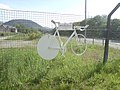 Jason MacIntyre ghost bike.jpg 1,024 × 768; 633 KB
-
 Junction for Renton - geograph.org.uk - 2950534.jpg 640 × 438; 55 KB
-
 Junction of A82 and A85 - geograph.org.uk - 2537623.jpg 1,632 × 1,224; 941 KB
-
 Junction of the A82 and the B862 - geograph.org.uk - 3217115.jpg 640 × 480; 73 KB
-
 Kenneth Street, looking northwest - geograph.org.uk - 2105921.jpg 1,024 × 759; 166 KB
-
 Lay By in Glen Falloch from A82 - geograph.org.uk - 3065846.jpg 640 × 455; 46 KB
-

-
 Lay-by on the A82 - geograph.org.uk - 4250650.jpg 640 × 411; 54 KB
-
 Lay-by on the A82 at Ruskich Wood - geograph.org.uk - 2957550.jpg 1,600 × 1,200; 755 KB
-
 Lay-by on the A82 at Stronaba - geograph.org.uk - 2145834.jpg 800 × 531; 170 KB
-
 Lay-by on the A82 near Altrua - geograph.org.uk - 4250821.jpg 1,024 × 698; 198 KB
-
 Lay-by, A82 - geograph.org.uk - 1067238.jpg 480 × 640; 83 KB
-
 Layby and AA Box 631 at Brachla (geograph 5345054).jpg 640 × 481; 535 KB
-
 Layby north of Torlundy - geograph.org.uk - 4019468.jpg 640 × 480; 302 KB
-

-
 Layby on the A82 alongside Loch Linnhe - geograph.org.uk - 4019324.jpg 640 × 480; 287 KB
-

-
 Layby on the A82 by Loch Ness. - geograph.org.uk - 250769.jpg 640 × 480; 99 KB
-
 Layby on the Northbound A82 - geograph.org.uk - 3961002.jpg 640 × 480; 277 KB
-
 Layby on the Northbound A82 - geograph.org.uk - 4019489.jpg 640 × 427; 259 KB
-
 Loch Ba temporary bridge - geograph.org.uk - 2991447.jpg 3,008 × 2,000; 391 KB


.jpg)
.jpg)


.jpg)
.jpg)


.jpg)


.jpg)


_-_geograph.org.uk_-_429169.jpg)


.jpg)


.jpg)


_Fort_William_-_geograph.org.uk_-_4019674.jpg)


.jpg)


&filefrom=Loch+Linnhe+with+the+A82+running+alongside+-+geograph.org.uk+-+1356860.jpg#mw-category-media)