Category:99 - 109 Bebington Road, Port Sunlight
Jump to navigation
Jump to search
| Object location | | View all coordinates using: OpenStreetMap |
|---|
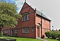
Grade II listed terrace in Wirral, England  | |||||
| Upload media | |||||
| Instance of | |||||
|---|---|---|---|---|---|
| Location | Wirral, Merseyside, North West England, England | ||||
| Heritage designation |
| ||||
 | |||||
Media in category "99 - 109 Bebington Road, Port Sunlight"
The following 2 files are in this category, out of 2 total.
-
 109 Bebington Road, Port Sunlight.jpg 4,795 × 3,261; 17.91 MB
-
 99 - 109 Bebington Road, Port Sunlight.jpg 4,617 × 1,967; 11.35 MB
