Category:2019 maps of India
Jump to navigation
Jump to search
Countries of Asia: People's Republic of China · India · Indonesia‡ · Philippines · Russia‡ · Syria · Turkey‡ · Turkmenistan · Yemen
‡: partly located in Asia
‡: partly located in Asia
| ← 2010 2011 2012 2013 2014 2015 2017 2018 2019 → |
English: 2019 maps made in India or from India or showing history of India
Media in category "2019 maps of India"
The following 23 files are in this category, out of 23 total.
-
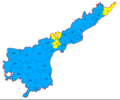 Andhra Pradesh Lok Sabha election 2019.png 720 × 601; 108 KB
-
 Bihar MGB Seat Sharing 2019.png 1,280 × 953; 231 KB
-
 ECDM 20190104 TC PABUK.pdf 1,625 × 1,125; 726 KB
-
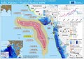
 ECDM 20190502 TC FANI.pdf 1,625 × 1,125; 849 KB
-
 ECDM 20190506 TC FANI update.pdf 1,625 × 1,125; 917 KB
-
 ECDM 20190611 India TC-VAYU.pdf 2,479 × 1,754; 1.18 MB
-
 ECDM 20190613 India TC-VAYU.pdf 2,479 × 1,754; 1.19 MB
-
 ECDM 20190715 Monsoon.pdf 2,479 × 1,754; 1.44 MB
-
 ECDM 20190725 Monsoon.pdf 2,479 × 1,754; 1.28 MB
-
 ECDM 20190816 Monsoon v2.pdf 2,479 × 1,754; 1.65 MB
-
 ECDM 20190920 Monsoon.pdf 2,479 × 1,754; 1.22 MB
-
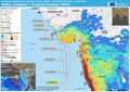
 ECDM 20191015 Monsoon season.pdf 2,479 × 1,754; 1.57 MB
-
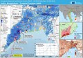
 ECDM 20191106 South-Asia TCs.pdf 1,625 × 1,125; 694 KB
-
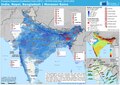
 Indian General Election 2019 all parties.svg 1,380 × 1,700; 5.65 MB
-
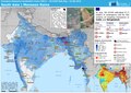
 Indian General Election 2019 by alliance.svg 1,326 × 1,488; 5.62 MB
-
 Indian General Election 2019-hi.svg 1,380 × 1,700; 4.95 MB
-
 Indian General Election 2019-ur.svg 1,380 × 1,700; 4.95 MB
-
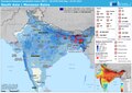
 Indian General Election 2019.svg 1,380 × 1,700; 5.74 MB
-
 Kerala Constituency wise Loksabha Results 2019.svg 510 × 694; 1.13 MB
-
 Maharashtra Lok Sabha election result 2019.png 720 × 472; 122 KB
-
 Mizoram legislative assembly structure.png 300 × 154; 19 KB
-
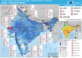
 State wise Elephant Population India, 2019.jpg 6,000 × 4,500; 4.73 MB
-
 Wahlergebnis Indien 2019.svg 1,340 × 1,630; 8.6 MB


