Category:2013 maps of the United States
Jump to navigation
Jump to search
Subcategories
This category has the following 6 subcategories, out of 6 total.
Media in category "2013 maps of the United States"
The following 13 files are in this category, out of 13 total.
-
 113th US House Liberty Caucus.svg 1,241 × 720; 1.21 MB
-
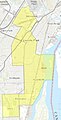
 2013 Cambridge congress districts.png 1,160 × 727; 267 KB
-
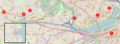 Boston marathon event map.png 2,618 × 964; 3.61 MB
-
 Cleveburgh Briem 2011.jpg 720 × 572; 83 KB
-
 Electricity price map of the United States 2013.jpeg 5,912 × 4,320; 8.38 MB
-
-
-
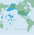 NOAA Map of the US EEZ.svg 612 × 613; 1.93 MB
-
 Periodical Cicada Broods of the United States.png 2,251 × 1,745; 3.24 MB
-

-
 State minimum wages v2.jpg 590 × 368; 50 KB
-
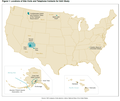
 United States - Location Map (2013) - USA - UNOCHA.svg 254 × 254; 2.96 MB
-
 United States Designated Market Areas 2013.svg 990 × 765; 6.67 MB


.png)


_-_USA_-_UNOCHA.svg)
