Category:2008 in Greater Manchester
Jump to navigation
Jump to search
Ceremonial counties of England: Bedfordshire · Berkshire · Buckinghamshire · Cambridgeshire · Cheshire · Cornwall · Cumbria · Derbyshire · Devon · Dorset · Durham · East Riding of Yorkshire · East Sussex · Essex · Gloucestershire · Greater London · Greater Manchester · Hampshire · Herefordshire · Hertfordshire · Isle of Wight · Kent · Lancashire · Leicestershire · Lincolnshire · Merseyside · Norfolk · North Yorkshire · Northamptonshire · Northumberland · Nottinghamshire · Oxfordshire · Rutland · Shropshire · Somerset · South Yorkshire · Staffordshire · Suffolk · Surrey · Tyne and Wear · Warwickshire · West Midlands · West Sussex · West Yorkshire · Wiltshire · Worcestershire
City-counties: Bristol · City of London
Former historic counties:
Other former counties:
City-counties: Bristol · City of London
Former historic counties:
Other former counties:
English: 2008 in Greater Manchester
Svenska: 2008 i Stor-Manchester
Subcategories
This category has the following 26 subcategories, out of 26 total.
Media in category "2008 in Greater Manchester"
The following 36 files are in this category, out of 36 total.
-
 Borsdane Brook, in the Danes Valley - geograph.org.uk - 1061270.jpg 640 × 426; 97 KB
-
 Bryn Ward Christmas Tree 2008 - geograph.org.uk - 1099389.jpg 640 × 480; 59 KB
-
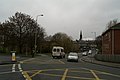 Complicated junction, Hindley - geograph.org.uk - 1061249.jpg 640 × 426; 55 KB
-
 Cyclist and Horse-riders This Way - geograph.org.uk - 835009.jpg 640 × 480; 138 KB
-
 Former Presbyterian Church, Wigan - geograph.org.uk - 856195.jpg 426 × 640; 71 KB
-
 Former Primitive Methodist Chapel - geograph.org.uk - 1061360.jpg 640 × 426; 49 KB
-
 Greater Manchester Transport bus 8551 (ANA 551Y), MMT Atlantean 50 event (3).jpg 1,600 × 1,200; 570 KB
-
 Hanging Gate Diggle - geograph.org.uk - 811617.jpg 640 × 480; 107 KB
-

-
 Heroes of Waterloo - geograph.org.uk - 1033115.jpg 640 × 521; 125 KB
-

-
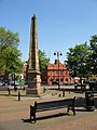 Leigh, Obelisk and Boar's Head - geograph.org.uk - 806241.jpg 480 × 640; 95 KB
-
 M62 motorway from Tunshill.jpg 3,470 × 1,690; 1.28 MB
-
 Marker Post on Long Causeway - geograph.org.uk - 727559.jpg 640 × 472; 90 KB
-
 Memorial Stone for a Pub and an industry - geograph.org.uk - 1766624.jpg 400 × 611; 212 KB
-
 More Apartments - geograph.org.uk - 1117959.jpg 640 × 446; 85 KB
-
 Mossley Road - geograph.org.uk - 1033103.jpg 640 × 480; 107 KB
-

-
 Salford Quays - geograph.org.uk - 1069996.jpg 640 × 480; 70 KB
-
 Sign of the Packhorse Inn - geograph.org.uk - 1133778.jpg 538 × 640; 120 KB
-
 St John's RC Church, Wigan-02 - geograph.org.uk - 856184.jpg 640 × 426; 74 KB
-

-

-

-

-

-

-
 The smallest field in England^ - geograph.org.uk - 887931.jpg 640 × 430; 300 KB
-
 The White - geograph.org.uk - 877830.jpg 640 × 480; 89 KB
-
 Wigan Baptist Church, old School - geograph.org.uk - 856217.jpg 640 × 426; 78 KB
-
 Wigan Baptist Church, old School door - geograph.org.uk - 856222.jpg 426 × 640; 99 KB
-
 Wigan Baptist Church-main entrances - geograph.org.uk - 856229.jpg 640 × 426; 81 KB
-
 Wigan Cycleway - geograph.org.uk - 869037.jpg 640 × 427; 219 KB
-

-

-
 Ye Olde Village Fish and Chip Shop - geograph.org.uk - 795512.jpg 640 × 480; 134 KB


,_MMT_Atlantean_50_event_(3).jpg)