Category:1985 maps of Alabama
Jump to navigation
Jump to search
States of the United States: Alabama · Florida · Georgia · Louisiana · Massachusetts · New Jersey · New York · Ohio · Virginia
| 1980 1981 1982 1984 1985 1986 1987 1989 → |
Media in category "1985 maps of Alabama"
The following 4 files are in this category, out of 4 total.
-
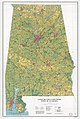 Land use and land cover, state of Alabama LOC 85696121.jpg 9,102 × 13,555; 22.2 MB
-
 Land use and land cover, state of Alabama LOC 85696121.tif 9,102 × 13,555; 352.99 MB
-
 Tuskegee National Forest, Alabama, St. Stephens meridian, 1982 LOC 2001624649.jpg 3,283 × 3,134; 1.93 MB
-
 Tuskegee National Forest, Alabama, St. Stephens meridian, 1982 LOC 2001624649.tif 3,283 × 3,134; 29.44 MB

