Category:1847 maps of the United States
Jump to navigation
Jump to search
Countries of the Americas: Mexico · United States of America
States of the United States: California · Illinois · Massachusetts · Michigan · New York · Pennsylvania · Texas
Subcategories
This category has the following 8 subcategories, out of 8 total.
C
- 1847 maps of California (8 F)
I
- 1847 maps of Illinois (2 F)
M
- 1847 maps of Michigan (1 F)
N
P
T
- 1847 maps of Texas (2 F)
Media in category "1847 maps of the United States"
The following 9 files are in this category, out of 9 total.
-
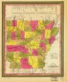
 A new map of Arkansas with its canals, roads & distances. LOC gm72003746.jpg 7,463 × 9,239; 9.37 MB
-
 A new map of Arkansas with its canals, roads & distances. LOC gm72003746.tif 7,463 × 9,239; 197.27 MB
-
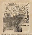 Julius Rubens Ames, Moral Map of U.S. 1847 Cornell CUL PJM 2051 01.jpg 3,080 × 3,300; 3.31 MB
-
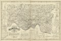
 Map of Hamilton County, Ohio LOC 2012591123.jpg 11,210 × 7,451; 13.25 MB
-
 Map of Hamilton County, Ohio LOC 2012591123.tif 11,210 × 7,451; 238.97 MB
-
 New map of the United States and Mexico. LOC 98685386.jpg 16,008 × 13,125; 25.17 MB
-
 New map of the United States and Mexico. LOC 98685386.tif 16,008 × 13,125; 601.12 MB
-
 United States 1846-12-1848-02.png 1,000 × 677; 87 KB
-
 Mitchell & Stealey Map of Mexico 1847 UTA (Map of Mexico).jpg 2,782 × 2,057; 6.62 MB


.jpg)