Category:1818 maps of the United States
Jump to navigation
Jump to search
States of the United States: Arizona · California · Illinois · Kentucky · Louisiana · Massachusetts · Michigan · New Mexico · Texas
Subcategories
This category has the following 10 subcategories, out of 10 total.
A
- 1818 maps of Arizona (1 F)
C
- 1818 maps of California (1 F)
I
- 1818 maps of Illinois (2 F)
K
- 1818 maps of Kentucky (1 F)
L
- 1818 maps of Louisiana (2 F)
M
- 1818 maps of Massachusetts (5 F)
- 1818 maps of Michigan (1 F)
N
- 1818 maps of New Mexico (1 F)
T
- 1818 maps of Texas (1 F)
Media in category "1818 maps of the United States"
The following 24 files are in this category, out of 24 total.
-
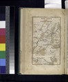
 1818 map Rhode Island byHarris BPL 14927.png 507 × 731; 594 KB
-

-

-

-
 1818 southeast Alabama townships.jpeg 6,145 × 3,557; 1.25 MB
-
 81 of 'History of Utah ... 1540-1887. (With a bibliography.)' (11114369105).jpg 1,382 × 721; 268 KB
-
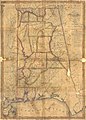 Alabama counties 1818.jpeg 1,887 × 2,633; 998 KB
-
 Charte von den Vereinigten Staaten von Nord-America mit Luisiana. LOC 2002621134.jpg 5,869 × 4,217; 4.9 MB
-
 Fort Montgomery, Alabama.jpg 944 × 761; 164 KB
-
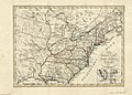
 Map of the United States including Louisiana. LOC 98685568.jpg 5,847 × 4,776; 4.87 MB
-
 Map of Tishomingo County, Mississippi - DPLA - 5bf231d4fa8093ea176171548b793e07.jpg 7,580 × 7,373; 2.68 MB
-
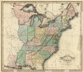
 Melish United States of America 1818 UTA.jpg 3,224 × 2,688; 1.73 MB
-
 New York and adjacent country. NYPL433876.tiff 2,320 × 2,802; 18.6 MB
-
-

-
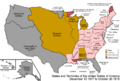 United States 1817-12-1818-10.png 1,000 × 677; 237 KB
-
 United States 1818-10-1818-12.png 1,000 × 677; 115 KB
-

-
 United States of America compiled from the latest & best authorities (NBY 15556).jpg 3,600 × 3,066; 2.24 MB
-
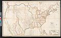
 United States of America LOC 2002621136.jpg 6,111 × 5,240; 5.48 MB
-
 United States of America LOC 2002621136.tif 6,111 × 5,240; 91.61 MB
-
 United States of America LOC 96688043.jpg 5,490 × 4,772; 4.29 MB
-
 United States of America LOC 96688043.tif 5,490 × 4,772; 74.95 MB
-
 United States of America. NYPL484197.tiff 5,643 × 4,880; 78.79 MB

_-_Geographicus_-_Texas-pinkerton-1818.jpg)


%27_(11114369105).jpg)


.jpg)


.jpg)

