File:Earth from Space- The Ebro Delta ESA496203.tiff

Original file (19,076 × 13,271 pixels, file size: 724.31 MB, MIME type: image/tiff)
Captions
Captions
Summary
[edit]| Warning | The original file is very high-resolution. It might not load properly or could cause your browser to freeze when opened at full size. |
|---|
| Description |
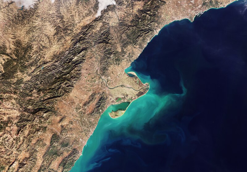
English: This Copernicus Sentinel-2 image shows the delta of the Ebro River on the northeast coast of Spain. Zoom in to explore this image at its full 10 m resolution or click on the circles to learn more. Stretching across 910 km of northern Spain, the Ebro River is the second-longest river in the Iberian Peninsula. In the image, it can be seen as a green line winding its way through the peninsula before flowing into the Mediterranean, shaping the Ebro Delta. The Ebro River discharges more water into the sea than any other river in Spain. As suspended sediment flows from the river’s mouth, it tints the coastal waters with a turquoise hue. Covering an area of about 320 sq km, the Ebro Delta is one of the largest wetlands in the western Mediterranean region. Most of the delta comprises the Ebro Delta Nature Reserve. With its protected wetlands, beaches, marshes, salt pans and estuaries, this reserve provides a natural habitat for numerous migratory birds and waterfowl. Zooming on the peninsula, several green lagoons dot the coastline, while much of the inland areas are dominated by agricultural fields, primarily rice paddies. These fields display a range of colours depending on the different stage of growth of the crops. The city of Amposta is in the centre of the peninsula, straddling the Ebro River. The coastal region surrounding the peninsula features a double system of mountain chains interspersed with plains. These plateaus are predominantly cultivated where crops such as wheat, barley, fruits and vegetables are grown. The city of Tarragona, home to one of the largest ports in Spain, is visible along the coast in the top right corner. Ships off the coast can be seen as colourful dots in the dark waters. Tarragona is an important agricultural market and a tourist destination thanks to the beautiful beaches near the city. With its five-day revisit and global coverage, Copernicus Sentinel-2 offers excellent opportunities for both regional and global agriculture monitoring. Its data can help to assess agricultural land use and trends, crop conditions and yield forecasts. |
| Date | 12 April 2024 (upload date) |
| Source | Earth from Space: The Ebro Delta |
| Author | European Space Agency |
| Other versions |
|
| Activity | Observing the Earth |
| Mission | Sentinel-2 |
| Set | Earth from Space image collection |
| System | Copernicus |

Licensing
[edit]
|
This image contains data from a satellite in the Copernicus Programme, such as Sentinel-1, Sentinel-2 or Sentinel-3. Attribution is required when using this image.
Attribution: Contains modified Copernicus Sentinel data 2024
The use of Copernicus Sentinel Data is regulated under EU law (Commission Delegated Regulation (EU) No 1159/2013 and Regulation (EU) No 377/2014). Relevant excerpts:
Free access shall be given to GMES dedicated data [...] made available through GMES dissemination platforms [...].
Access to GMES dedicated data [...] shall be given for the purpose of the following use in so far as it is lawful:
GMES dedicated data [...] may be used worldwide without limitations in time.
GMES dedicated data and GMES service information are provided to users without any express or implied warranty, including as regards quality and suitability for any purpose. |
This media was created by the European Space Agency (ESA).
Where expressly so stated, images or videos are covered by the Creative Commons Attribution-ShareAlike 3.0 IGO (CC BY-SA 3.0 IGO) licence, ESA being an Intergovernmental Organisation (IGO), as defined by the CC BY-SA 3.0 IGO licence. The user is allowed under the terms and conditions of the CC BY-SA 3.0 IGO license to Reproduce, Distribute and Publicly Perform the ESA images and videos released under CC BY-SA 3.0 IGO licence and the Adaptations thereof, without further explicit permission being necessary, for as long as the user complies with the conditions and restrictions set forth in the CC BY-SA 3.0 IGO licence, these including that:
See the ESA Creative Commons copyright notice for complete information, and this article for additional details.
|
 | |
This file is licensed under the Creative Commons Attribution-ShareAlike 3.0 IGO license. Attribution: ESA, CC BY-SA IGO 3.0
| ||
File history
Click on a date/time to view the file as it appeared at that time.
| Date/Time | Thumbnail | Dimensions | User | Comment | |
|---|---|---|---|---|---|
| current | 06:07, 12 May 2024 |  | 19,076 × 13,271 (724.31 MB) | OptimusPrimeBot (talk | contribs) | #Spacemedia - Upload of https://esamultimedia.esa.int/docs/EarthObservation/EbroDelta_S2_20240125_10m_432_3857_enhanced.tif via Commons:Spacemedia |
You cannot overwrite this file.
File usage on Commons
The following page uses this file: