User talk:Kami888
Filnik 05:46, 4 March 2008 (UTC) Soldiers are reaching city center, you are sleeping for while boss!
.svg)
The File:Rif Aleppo2.svg contains raster elements[edit]
Quality issue 
|
The SVG image File:Rif Aleppo2.svg you uploaded contains embedded raster graphics and is now listed in Category:SVG images with embedded raster graphics. Such images are liable to produce inferior results when scaled to different sizes. If appropriate, please replace the raster graphics with vector graphics. You can either upload an improved version or simply allow the file to be deleted.
In all cases, please do not take this message personally. It is never intended as such. Thank you! --Cwbm (commons) (talk) 10:00, 30 March 2014 (UTC) |
The File:Rif Damashq.svg contains raster elements[edit]
| Quality issue
|
The SVG image File:Rif Damashq.svg you uploaded contains embedded raster graphics and is now listed in Category:SVG images with embedded raster graphics. Such images are liable to produce inferior results when scaled to different sizes. If appropriate, please replace the raster graphics with vector graphics. You can either upload an improved version or simply allow the file to be deleted.
In all cases, please do not take this message personally. It is never intended as such. Thank you! --Cwbm (commons) (talk) 10:17, 30 March 2014 (UTC) |
The File:Rif Aleppo.svg contains raster elements[edit]
| Quality issue
|
The SVG image File:Rif Aleppo.svg you uploaded contains embedded raster graphics and is now listed in Category:SVG images with embedded raster graphics. Such images are liable to produce inferior results when scaled to different sizes. If appropriate, please replace the raster graphics with vector graphics. You can either upload an improved version or simply allow the file to be deleted.
In all cases, please do not take this message personally. It is never intended as such. Thank you! --Cwbm (commons) (talk) 10:19, 30 March 2014 (UTC) |
Western Ghouta[edit]
can you add the towns of Dirkhabiyah,Zakyah,Mukaylibah,Al-Taybah as rebel-held on the rif dimashq map it has been agreed on by editors 73.178.220.158 17:59, 21 September 2014 (UTC)
Moscow_Victory_Parade_2015_vs_2010.svg[edit]
Can you please fix your map for Moscow Parade? Belarus president denied invitation and didn't participate in the parade (for whatever reason he gave). QuantumShadow (talk) 10:51, 12 May 2015 (UTC)
- See this: [1] Kami888 (talk) 04:38, 13 May 2015 (UTC)
Rif Aleppo2.svg and a question to SVG-editing[edit]
Hello,
the Rif Aleppo2.svg isn't actual anymore, since the SAA completed the siege. I would do it tomorrow maybe, but I have a question to SVG-editing to you, because on the map it looks like you have some technic that prevents the overlapping of to partially transpatent objects (in this case: the frontlines). Is there a way to connect them together on a line or has it to be done manually?
Apart from that, thanks for your edits on the maps of Wikipedia!
Best wishes, Ermanarich (talk) 16:33, 29 July 2016 (UTC)
- Hi Ermanarich. I'm personally waiting for the situation to clear up before updating the map. For example, I'm still not clear whether or not the tiger forces and 4th mechanized have actually linked up together or not yet - not a single picture or confirmation emerged so far that they did. It's hard to update without certainty over something so important.
- As for the technique for preventing overlapping, yes, there is one, I will try to explain. What you do is you make at least ONE of the objects (say, object A) have actually accurate borders, the way you will want the frontline to look like in the end, and you let object B overlap with object A and don't bother giving it any accurate shape at all in places where it's supposed to be adjacent to object A. Then what you do is you select object A, the one that has an accurate border, right click on it and select "Duplicate". Then, without deselecting the newly created duplicate, you hold "Shift" and also select object B. Then go to Path->Difference, and you're done. Object A and Object B should now share a nice, non-overlapping common border. Kami888 (talk) 00:34, 30 July 2016 (UTC)
- Well, as it turns out, I can't actually update it anyway, there seems to be some sort of glitch. You're welcome to try though. :) Kami888 (talk) 03:33, 31 July 2016 (UTC)
- Thank you very much for your help! This could be very helpful for me in future. As for the Aleppo map, I actually won't find time to do it in the next days.--Ermanarich (talk) 23:30, 2 August 2016 (UTC)
- Well, as it turns out, I can't actually update it anyway, there seems to be some sort of glitch. You're welcome to try though. :) Kami888 (talk) 03:33, 31 July 2016 (UTC)
Al-Tall[edit]
Kami, if you could, please refresh the map of Rif Dimashq. Al-Tall city north of Damascus was handed over to the Syrian Army yesterday. https://www.almasdarnews.com/article/jihadist-rebels-officially-surrender-key-damascus-suburb-syrian-government/ https://www.almasdarnews.com/article/pictures-islamist-rebels-surrender-new-city-north-damascus-syrian-army/ — Preceding unsigned comment was added by 78.88.31.217 (talk) 16:51, 03 December 2016 (UTC)
.svg)
Thanks for that map ! Very good :) MrPenguin20 and myself are maintaining the map making effort on Iraq / Syria related map. Feel free to chat with us and share tips with us :) -Yug 15:40, 24 December 2016 (UTC)
.svg)
- Thank you! If I need help with something I'll come to you. :) Kami888 (talk) 01:44, 25 December 2016 (UTC)
Jarba and Qasimiyah[edit]
Kami, what do you think on Peto Lucem maps saying those villages are under SAA? Since July '16 every of his map of Eastern Ghouta consists of the towns under army... — Preceding unsigned comment was added by 78.88.31.54 (talk) 21:03, 29 December 2016 (UTC)
- I have seen a number of pro-government mappers showing these villages under SAA control, but I could not find any confirmation of that from the pro-rebel groups or from independent sources, so I kept it as is. Given that nobody had put those towns as government-held on the general map either, keeping it "as is" appears to be the current consensus on English wikipedia. Kami888 (talk) 02:17, 31 December 2016 (UTC)
Mosul Map[edit]
First, thank you for your work on the map :). One thing though: I noticed that 'cement' was misspelled in the top left hand corner (Badush Ciment Factory). Dschslava (talk) 22:51, 6 January 2017 (UTC)
- Thanks! Corrected. Kami888 (talk) 11:10, 7 January 2017 (UTC)
Eastern Aleppo CS[edit]
Hello Kami! Can you refresh the Aleppo map upon recent SAA advances against ISIS? The village of Suran, Barlehiyah, Shamir, Rasm al-Aabd are liberated so far. Fighting at Marran. Thank you.
- Yeah, was just about to do that. Kami888 (talk) 01:41, 22 January 2017 (UTC)
Al-Qasimiyah[edit]
https://twitter.com/maytham956/status/824588673761116160?ref_src=twsrc%5Etfw This is the rather reliable source from Syria. Says Qassimiyah has been taken by SAA. What would you think about this? — Preceding unsigned comment was added by 78.88.28.210 (talk) 19:18, 26 January 2017 (UTC)
Al-Qasimiyah[edit]
https://twitter.com/maytham956/status/824588673761116160?ref_src=twsrc%5Etfw This is the rather reliable source from Syria. Says Qassimiyah has been taken by SAA. http://stepagency-sy.net//nfiles//2017/01/148545515770571.jpg pro-rebel map shows SAA had already captured Jarba and Qassimiyah. What would you think about this Kami? — Preceding unsigned comment was added by 78.88.28.210 (talk) 19:22, 26 January 2017 (UTC)
- Well, if pro-rebel Step news is showing them under government control, then I guess it's time to update. Kami888 (talk) 01:56, 27 January 2017 (UTC)
Esh Warwar[edit]
This neighbourhood is located north to Barzeh. However, it is Alawite district in contrast to the Barzeh that is mostly Sunni, so it is most probably under SAA. — Preceding unsigned comment was added by 78.88.28.11 (talk) 22:45, 1 February 2017 (UTC)
- I don't know who drew the area the way it is right now on the map, but without sources I can't really change it. Kami888 (talk) 02:29, 3 February 2017 (UTC)
Esh Warwar[edit]
https://www.youtube.com/watch?v=YdFh1R4Id-0 This is a video of Syrian state TV from the district in 2013 and this one from 2015 - https://www.youtube.com/watch?v=b1hJy3vYhTw However I don't remember further reports saying it has fallen to rebels — Preceding unsigned comment was added by 78.88.28.36 (talk) 22:13, 3 February 2017 (UTC)
Mosul battle map[edit]
Hello Kami888, Please check out my work on File:Northern_Raqqa_Offensive_(November_2016).svg. I record dates and chronolines so the final map provide more information on the battle progress. As the battle for the Western Mosul start, it could be a good time to start adding such chronolines. Also, all my thanks for your contributions ;) --Yug (talk) 11:05, 20 February 2017 (UTC)
.svg)
.svg)
- That's a very pretty map. As for adding chronolines to the Mosul battle map, it would have to be a separate map from the Battle of Mosul.svg, because this one is linked in maps of the current situation where chronolines and arrows would be inappropriate. But this one makes a good candidate for editing. Kami888 (talk) 08:27, 21 February 2017 (UTC)
.svg)
Mosul Battle map[edit]
Hi kami888,
I have a few questions about your map. Could you email me? valentin.tombez(at)gmail.com
Thanks, v.
- I could, but I'd greatly prefer to chat discuss wiki-related subjects here. There's nothing about the map that is secret as far as I know, so any questions you might have, I can answer them here. :) Kami888 (talk) 02:13, 1 March 2017 (UTC)
ok Kami888 :) I'm a journalist at the swiss TV in Geneva (Radio Télévision Suisse, RTS) and I find your work very interesting. I'm just wondering:
- what sources do you use?
- why do you do it? what's your motivation?
- who are you (country, profession, age, gender, ..)?
Have a great day,
--Valouhhh (talk) 08:30, 1 March 2017 (UTC)
Hi Valouhhh, I'll try to answer your questions:
- what sources do you use?
That depends on the particular map. Speaking of the Battle of Mosul map in particular, to be frank the sources used in it are rather one sided and often not of the best quality, but it's the best quality that we can get. The sources for the changes to the map consist primarily of statements from Iraqi Ministry of Defense and government officials as well as pro-Iraqi government bloggers/activists. For example, here's the facebook page of the Nineveh Media Center which supplies regular updates on the battle of Mosul, and here's one of the aforementioned pro-government bloggers.
More traditional/authoritative sources of information are of course preferred where available, but unfortunately for map-making purposes, most major news organizations care more about the "big picture" or narrative they want to sell, rather than specific operational details, therefore it is hard to find information about specific changes on the battlefield from any major traditional news media. So far, if anything, I have only been criticized for being too slow and too cautious to update, trying to wait for confirmation from a (relatively) authoritative source rather then going off of what someone on twitter with a total of 34 followers has to say :D.
Why no pro-ISIS sources? Well, for one, they are not very easy to come by, thanks to the fact that most of them get routinely banned from every platform that they appear on. As a result, it's hard to get any information "from the other side". I knew one pro-ISIS "twitter activist" RamiAlLolah, he's been banned for a while now, before him there was this Indian guy, ShamiWitness, he's not just banned now, he's actually in jail as far as I know. And it's the same story every time a new pro-ISIS source appears, so there's that. Another problem is that news organizations and activists really prefer not to report things which their target audience might not want to hear, and ISIS has been on a near constant retreat for quite some time now. So if we look at Amaq press agency statements, for example, on the subject of battlefield changes it's mostly just silence - they're not going to report on their own defeats, unless it's a major one like Al Bab perhaps. But the main and biggest reason is because reliance on pro-government side alone had so far simply not proven to be an issue. This is wikipedia, therefore anyone can either revert changes or introduce their own changes if they feel like they have information which contradicts mine, but so far that has never been done - which could mean one of two things: either the pro-government sources I use are objectively reliable and trustworthy, or that the public opinion on English wikipedia is stacked so heavily against ISIS that nobody really cares to verify it. But that would be a general wikipedia problem, not just related to this particular map.
However if you were to look at, say, the Battle of Aleppo map, you'll find a somewhat better balance of sources being used there typically, with the main ones being pro-government Al Masdar News and pro-rebel Step News Agency, as well as other sources and activists on both sides.
- why do you do it? what's your motivation?
Hobby. Not much to say about this, we've all got to spend our free time somehow. :) I like maps, I follow /r/MapPorn/ on Reddit, and I occasionally make maps of my own.
- who are you (country, profession, age, gender, ..)?
US citizen (but immigrant from a muslim country - hence increased interest in that part of the world), software engineer, 28, male. Overall fairly typical demographic for an English wikipedia user. :)
Hopefully my answers are satisfactory. :) Kami888 (talk) 09:58, 2 March 2017 (UTC)
- Thank you very much! Very informative. I wrote a small article about your map, it's here (but in french). Thanks again for your answers. --Valouhhh (talk) 13:31, 2 March 2017 (UTC)
- Nice. :) More publicity means more accountability, hopefully. Kami888 (talk) 03:51, 3 March 2017 (UTC)
Qaboun offensive badly needs map update[edit]
Hello I've personally never worked with maps so dont know much about them, I've seen you've been updating them in the past but later stopped, well the one for Qaboun offensive (February–March 2017) needs new map badly, the one presented there by you aeons ago is horribly outdated, for example:
- Hayyat Tahrir al-Sham seized some ground from Islamic State of Iraq and Levant, source: https://www.almasdarnews.com/article/photos-al-qaeda-blitzes-isis-in-south-damascus/
- The Qaboun pocket doesnt consist of mainly Barzeh neighbourhood, tbh majority of that neighbourhood is long time in government hands, even pro-rebel maps such as most notoriously this one: http://syria.liveuamap.com/ admits that.
- Rebels have slightly larger control directly north of Jobar
- Rebels do not have any control of the road north of Jaramana
If you'd take your time to update the map would be very grateful, whenever you could find some free time, thank you in advance. — Preceding unsigned comment added by GroundlessAir (talk • contribs) 20:53, 21 March 2017 (UTC)
- Thanks for pointing it out! Yeah I know that map is rather outdated, unfortunately I am a bit busy this week but I'll try to find time to update as you recommended. Kami888 (talk) 01:07, 22 March 2017 (UTC)
- Updated! But some things I am confused abotu:
- >* Hayyat Tahrir al-Sham seized some ground from Islamic State of Iraq and Levant, source: https://www.almasdarnews.com/article/photos-al-qaeda-blitzes-isis-in-south-damascus/
- That map seems to show the same exact thing that our map already shows, so where is the change?
- >* Rebels do not have any control of the road north of Jaramana
- Which road is that? It looks like the map already shows the government in control of Jaramana and roads that run parallel to it. Kami888 (talk) 02:49, 23 March 2017 (UTC)
- Hello, thank you very much for affording some precious time to update map, certainly didn't have much hope you would but you did, as for the section of road, well i've highlighted it here, it's not some extremely major highway, so i didn't knew its specific name so had trouble describing where is it,excuse me for that: http://i.imgur.com/ldlmQV5.png GroundlessAir (talk) 21:25, 23 March 2017 (UTC)
From https://www.almasdarnews.com/article/breaking-syrian-army-fully-recaptures-key-rebel-stronghold-northeast-damascus/ Qabun taken by SAA and Barzeh on truce awaiting for evacuation. Could you please fix them Damascus ap?
Barzeh taken by SAA https://www.almasdarnews.com/article/barzeh-district-damascus-officially-syrian-govt-control-first-time-6-years/. Could you update? PaoloWalter — Preceding unsigned comment added by Paolowalter (talk • contribs) 14:11, 29 May 2017 (UTC)
Al-Hasakah map update[edit]
Hi. Can you please upload a new version of the Al-Hasakah battle map? The current version is the map is vastly outdated; the SDF have taken control of 95% of the city since the last update. The Syrian Government now controls only a small area in the city center of Al-Hasakah, dubbed the "Security Box." You can find a map with the updated frontline in Al-Hasakah city here (the Syriac Military Council's areas of control in Al-Hasakah city are not shown). Thank you. LightandDark2000 (talk) 01:41, 9 June 2017 (UTC)
- If you look at the uses section, currently this map is being used in Battle of al-Hasakah (2015) to show the situation AFTER the 2015 battle and in Battle of al-Hasakah (2016) to show the situation BEFORE the 2016 battle. So if I update this map now, both articles will point to incorrect maps. The correct solution is just to create a brand new map for the current situation, but that would be a very boring map since it would be 99% SDF controlled. I can't be bothered with that but if you want to do it, be my guest. :P Kami888 (talk) 06:19, 10 June 2017 (UTC)
- In the 2016 article, the image used is actually supposed to show the situation after the battle, not before (an updated image wasn't available back then). As for the 2015 article, I can always replace the image shown in the 2nd infobox, or remove it entirely. The original .svg battle maps are supposed to be updated to currency anyhow; in principle, if someone wanted to keep an image of the situation during or before a battle, they should generate a new image using an older revision of the file, while the source image continues getting updated. I can do that perfectly fine, but the problem is that I currently don't have the ability to generate .svg battle maps, which is why I would like you to update it. (It may be "boring", but I think that a lot of users would like to see an updated map on Wikipedia, and I've already come across multiple requests for an updated image.) LightandDark2000 (talk) 04:15, 11 June 2017 (UTC)
- Ok sure I've updated the map as you asked. Please fix the two articles I mentioned so they don't have inaccurate info. Kami888 (talk) 09:13, 11 June 2017 (UTC)
- The info/images have been updated for both articles. I will probably generate another map in png format for the 2015 article at some point in the future, based on a past revision of the map. BlueHypercane761 (talk) 10:10, 14 June 2017 (UTC)
- Ok sure I've updated the map as you asked. Please fix the two articles I mentioned so they don't have inaccurate info. Kami888 (talk) 09:13, 11 June 2017 (UTC)
- In the 2016 article, the image used is actually supposed to show the situation after the battle, not before (an updated image wasn't available back then). As for the 2015 article, I can always replace the image shown in the 2nd infobox, or remove it entirely. The original .svg battle maps are supposed to be updated to currency anyhow; in principle, if someone wanted to keep an image of the situation during or before a battle, they should generate a new image using an older revision of the file, while the source image continues getting updated. I can do that perfectly fine, but the problem is that I currently don't have the ability to generate .svg battle maps, which is why I would like you to update it. (It may be "boring", but I think that a lot of users would like to see an updated map on Wikipedia, and I've already come across multiple requests for an updated image.) LightandDark2000 (talk) 04:15, 11 June 2017 (UTC)
Malawi[edit]
Please, fix the Mosul map. Malawi and its neighborhoods have been fully captured. (http://isis.liveuamap.com/), (http://isis.liveuamap.com/en/2017/12-june-iraqi-72nd-bde-15th-div--and--75th-bde-16th-div-retake). — Preceding unsigned comment was added by 178.204.118.218 (talk) 12:04, 13 June 2017 (UTC)
Phased map of Mosul battle[edit]
Hello, the map you uploaded has almost all areas under Iraqi control, so it makes no point any more as the battle is over or almost over (some poclets remain). Anyeay, I hope you can prepare a phased map, showing all the major advances in particular directions during a period like the map of Raqqa campaign. The battle may not be over yet completely, but at least you can start oreparing it in advance. MonsterHunter32 (talk) 01:29, 10 July 2017 (UTC)
- Wah, I could try but I am fairly busy lately, so I don't really know if I have the bandwidth to take up anything like that. I would, but then I feel like by the that I'm done, someone would have already beaten me to it. :P Kami888 (talk) 06:09, 12 July 2017 (UTC)
Deir ez-Zor map update[edit]
@Kami888: Hi. Can you please update the battle map for Deir ez-Zor? The battle has completely concluded by now, and all of the "disputed" territory currently marked on the map was captured a while back. Most of the shaded area was captured by the SAA. You can see what the frontline around that area probably looks like here. Thank you. LightandDark2000 (talk) 07:02, 5 November 2017 (UTC)
- You're talking about that region north of Euphrates that is currently marked as contested/unclear, right? Yeah the problem is with the "probably looks like" part - every source that I've seen has a different opinion of what that area looks like. We've had conflicting reports of capture by the SAA and SDF through twitter accounts, and it's never been resolved one way or the other as far as I know. If you feel like taking the risk of being reverted, you can try your luck with it and commit the change yourself, then see if someone reverts you. Kami888 (talk) 07:34, 5 November 2017 (UTC)
- There seems to be at least some consensus on my proposed change. This is the situation currently displayed in the Syrian Civil War detailed map module on Wikipedia (the source for most of the derivative maps in general), and so far, no one has reverted/altered the territorial control there for around 2 weeks. I take that as enough consensus to go ahead with the changes; any further reverts here on Commons are usually due to problematic/POV-biased editors, and if such reverts happen here on Commons, I will be more than happy to counter-revert them. LightandDark2000 (talk) 21:46, 5 November 2017 (UTC)
- Alright fine, I'll match it with what the module shows. Kami888 (talk) 03:11, 6 November 2017 (UTC)
- Thanks.
 LightandDark2000 (talk) 05:17, 6 November 2017 (UTC)
- Thanks.
- Alright fine, I'll match it with what the module shows. Kami888 (talk) 03:11, 6 November 2017 (UTC)
- There seems to be at least some consensus on my proposed change. This is the situation currently displayed in the Syrian Civil War detailed map module on Wikipedia (the source for most of the derivative maps in general), and so far, no one has reverted/altered the territorial control there for around 2 weeks. I take that as enough consensus to go ahead with the changes; any further reverts here on Commons are usually due to problematic/POV-biased editors, and if such reverts happen here on Commons, I will be more than happy to counter-revert them. LightandDark2000 (talk) 21:46, 5 November 2017 (UTC)
File:Rif Aleppo2.svg[edit]
YPG hand over all districts controlled by YPG in Aleppo to SAA. Need to update a map.Links:### --Mehmedsons (talk) 10:56, 22 February 2018 (UTC)
- YPG hand over all districts controlled by YPG in Aleppo to SAA. Link:# It's a current Map:#--Mehmedsons (talk) 21:36, 22 February 2018 (UTC)
- Thanks, it's updated. Kami888 (talk) 03:01, 23 February 2018 (UTC)
- SAA controlled Fafin north Aleppo after retreating of SDF/YPG from the area. Link:#--Mehmedsons (talk) 10:21, 25 February 2018 (UTC)
- Done. Kami888 (talk) 04:08, 26 February 2018 (UTC)
- SAA controlled Fafin north Aleppo after retreating of SDF/YPG from the area. Link:#--Mehmedsons (talk) 10:21, 25 February 2018 (UTC)
- Thanks, it's updated. Kami888 (talk) 03:01, 23 February 2018 (UTC)
File:Rif Damashq.svg[edit]
Need updated the map after SAA gains at Eastern Ghouta. Link: #--Mehmedsons (talk) 21:18, 26 February 2018 (UTC)
- Link: ##--Mehmedsons (talk) 09:29, 28 February 2018 (UTC)
- Link: ##--Mehmedsons (talk) 20:44, 28 February 2018 (UTC)
- Will update shortly. Kami888 (talk) 21:05, 28 February 2018 (UTC)
- Link: ##--Mehmedsons (talk) 20:44, 28 February 2018 (UTC)
- New SAA advance! Links and maps: ####--Mehmedsons (talk) 16:46, 3 March 2018 (UTC)
- Addition. Maps: ##--Mehmedsons (talk) 19:56, 3 March 2018 (UTC)
- There are some conflicting reports about Al Rayhan, Muhammadiyah, Beit Naem, and Al Shifuniyah. I'll give it at least a few hours for the situation to clear up before updating. Kami888 (talk) 00:21, 4 March 2018 (UTC)
- Beit Naem and Al Shifuniyah taken SAA Links/Map:#link But Muhammadiyah-not yet taken!--Mehmedsons (talk) 16:52, 4 March 2018 (UTC)
- New SAA gains. SAA was able to impose full control over the town of Al-Muhammadiyah and its corresponding farms Links/maps: ####--Mehmedsons (talk) 20:27, 5 March 2018 (UTC)
- Changes in battle of Harasta. Link/map: ## #--Mehmedsons (talk) 11:48, 6 March 2018 (UTC)
- New map and source. Link:####--Mehmedsons (talk) 20:52, 7 March 2018 (UTC)
- Got it updated, I think. Kami888 (talk) 02:40, 8 March 2018 (UTC)
- New map and source. Link:####--Mehmedsons (talk) 20:52, 7 March 2018 (UTC)
- SAA take Hawsh Ash’ari, Hawsh Qubaybat and Aftris Air Defence Battalion. Map: # Links:## Visual prove:##--Mehmedsons (talk) 18:01, 8 March 2018 (UTC)
- SAA captured Mesraba and Kilani gas station. Links: ## Maps: ##--Mehmedsons (talk) 20:19, 10 March 2018 (UTC)
- SAA captured Madira. Link:## Map: # and advance in Harasra and divided the Ghouta-pocket into two parts. Map:#--Mehmedsons (talk) 22:56, 11 March 2018 (UTC)
- SAA take Aftris, besieges Harasta and divided the Ghouta-pocket into three parts. Link:###Map: #--Mehmedsons (talk) 11:34, 12 March 2018 (UTC)
- SAA controlled Al Qadam west of Hajar al Aswad south of Damascus. Link:#--Mehmedsons (talk) 14:12, 13 March 2018 (UTC)
- Current map for Al Qadam and the southern Damascus. Map:#--Mehmedsons (talk) 18:33, 13 March 2018 (UTC)
- Current map for the East Ghouta after recently SAA advance. Map/link:#--Mehmedsons (talk) 21:07, 14 March 2018 (UTC)
- SAA captured Hamouriyah and Jisreen. Links: ## ### and Rayhan. Link: # Current Map: #--Mehmedsons (talk) 15:55, 16 March 2018 (UTC)
- SAA captured Saqba and Kafr Batna. Link: # New Map: #--Mehmedsons (talk) 13:37, 18 March 2018 (UTC)
- Map for Al Qadam south Damascus: # and SAA entered to Harzeh north Kafr Batna. Link: #--Mehmedsons (talk) 14:17, 20 March 2018 (UTC)
Big changes in East Ghouta as all the areas except Douma surrendered to the government forces. Links:###[2]# ##--Mehmedsons (talk) 17:28, 23 March 2018 (UTC)
- Map: #--Mehmedsons (talk) 18:21, 23 March 2018 (UTC)
- East Ghouta Map Update: after Syrian Army take back all area except of Douma after rebels surrender. Links: ## Map: #--Mehmedsons (talk) 22:30, 23 March 2018 (UTC)
- Harasta and Ayn Tarma taken but others surrendered except Douma. Link: # Maps: ##--Mehmedsons (talk) 18:26, 24 March 2018 (UTC)
- Hey, I can't find an actual confirmation that the Syrian army took Harasta, I don't think the army entered yet. Let's wait for them to take pictures from inside the town. Kami888 (talk) 10:44, 25 March 2018 (UTC)
- According SOHR: Regime take Harasta and the second and final batch of buses departs from Harasta to North Syria. Link: # And other opposition sources confirm regime take Harasta. #[3]#--Mehmedsons (talk) 16:35, 25 March 2018 (UTC)
- Video: All rebels left the town Harasta. # Map: ##--Mehmedsons (talk) 20:38, 25 March 2018 (UTC)
- Harasta and Ayn Tarma taken but others surrendered except Douma. Link: # Maps: ##--Mehmedsons (talk) 18:26, 24 March 2018 (UTC)
- All area of East Ghouta need makred to red except Douma. Almost all the rebels evacuated from those areas and SAA enter to them. And now most of army forces moving towards Douma. Links: ## Map: # All rebels that signed agrement with SAA and which will be depared to Idlib in coming three day concentrated inside the town Irbin. Link: #--Mehmedsons (talk) 10:32, 27 March 2018 (UTC)
- SAA controlled entire area of East Ghouta except the town of Douma. Link: # Map: #--Mehmedsons (talk) 14:43, 28 March 2018 (UTC)
- According SOHR: Regime forces impose their control over the entire eastern Ghouta except Douma. Link: # Maps: ###--Mehmedsons (talk) 19:18, 31 March 2018 (UTC)
- SAA controlled whole of East Ghouta including the city of Douma. Links:# ## Map: #--Mehmedsons (talk) 09:33, 12 April 2018 (UTC)
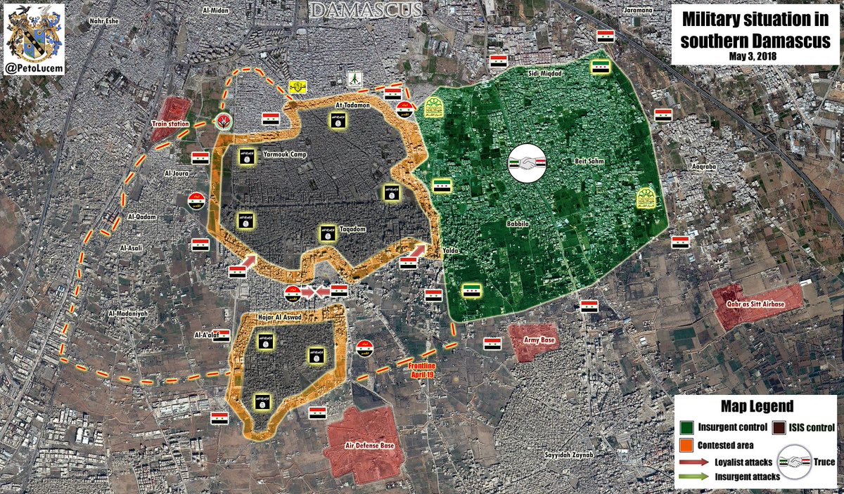
- Current map show the military situation in southern Damascus. Map:#--Mehmedsons (talk) 18:39, 15 April 2018 (UTC)
- SAA offensive south of Damascus. Updates at map: ####--Mehmedsons (talk) 15:37, 23 April 2018 (UTC)
- New updates. Map: # Mehmedsons (talk) 11:20, 26 April 2018 (UTC)
- Thanks for updates! Other sources confirm these changes. Links: ###Mehmedsons (talk) 19:57, 26 April 2018 (UTC)
- New SAA gains in Hajar al Aswad against ISIS.Map:# SOHR confirm new gains.## Also SAA captured some blocks in Tadamon district and entered in Yarmouk Camp after the evacuation of HTS finished and now SAA controls part of Yarmouk. Map:# Link: #Video: # Mehmedsons (talk) 07:48, 2 May 2018 (UTC)
- Syrian Army splits ISIS-held pocket in south Damascus on two parts. sources: #### Maps: ####Mehmedsons (talk) 17:41, 3 May 2018 (UTC)
- Updated! :) Kami888 (talk) 18:03, 4 May 2018 (UTC)
- Thanks. Good work! New updates - SAA captured entire southern pocket of Hajar al Aswad and take most of ISIS-held pocket. Links: ## Maps: # SOHR also confirmed that SAA control of most of al-Hajar al-Aswad neighborhood.# Mehmedsons (talk) 12:20, 5 May 2018 (UTC)
- All rebel groups completely evacuated from Damascus only small ISIS-held pocket remaining but completely surrounded by SAA. Links: ### Map:## Mehmedsons (talk) 20:49, 6 May 2018 (UTC)
- Need update. SOHR: ISIS loses Hajar al-Aswad neighborhood completely for SAA. Link:# Mehmedsons (talk) 20:34, 15 May 2018 (UTC)
- Apologies, was traveling. Updated now and looks like it's done.. Kami888 (talk) 02:15, 22 May 2018 (UTC)
A barnstar for you![edit]

|
The Graphic Designer's Barnstar |
| You are one of the best map makers. Good work! |
- Thank you. :) Kami888 (talk) 05:57, 8 May 2018 (UTC)
File:Battle of Hasakah.svg[edit]
Hello! You can update this map after the Al-Nashwa district Map:# in Hasakah back to under control the SAA.Link:# Mehmedsons (talk) 06:31, 11 July 2018 (UTC)
Syrian Civil War map.svg[edit]
Hi, Would you mind updating that map actual map so that it reflects the current situation on the ground. Because this map is severely outdated and needs updating, as like the Syrian Civil War detailed map.--Mehmedsons (talk) 11:02, 29 December 2018 (UTC)
- Hi! Other than some minor changes in the ISIS pocket on the east side of the Euphrates and SAA presence in Tel Riffat and Manbij countryside, is there anything else that needs updating? Kami888 (talk) 22:13, 30 December 2018 (UTC)
- Made some updates. Let me know what you think. Kami888 (talk) 00:28, 1 January 2019 (UTC)
A barnstar for you![edit]
|
|
The Graphic Designer's Barnstar |
| Thank you so much for quick and correct map updates! And I congratulate you on the New Year! Mehmedsons (talk) 10:24, 1 January 2019 (UTC) |
misinformation on the war in Abkhazia map[edit]
Dear Kami888, Image:1993 Georgia war1.svg shows Russian black sea fleet "providing aid to the Georgian defence of Sokhumi (1993)." This is inaccurate claim and there was no such "aid" for the Georgian side. On contrary, the Russian military and its fleet supported the Abkhaz separatist offensive on Sokhumi from Ochamchire line and with aerial bombing of Georgian positions in Sokhumi and on the Gumista rover. There are numerous sources which can verify this but you cant find any single neutral source which would back up your claim. Can you please be so kind to fix this or I will nominate this image for deletion based on inaccurate and misleading information. Thanks a lot. Iberieli (talk) 14:59, 14 March 2021 (UTC)
ISIS pocket in the central desert[edit]
Could you please review this discussion [4] and, based on the multiple sources, re-add the ISIS central desert pocket to the Syrian war map which was previously removed. The previous removal was made by an editor based on the general Syria-Iraq-Lebanon map (which is contrary to Wikipedia's policy of using itself as a source). The Syria-Iraq-Lebanon map hah has since then reinserted the pocket. Seems the most significant location held by ISIS in the area is the Doubayat gas field, properly marked as ISIS-held here [5]. EkoGraf (talk) 03:09, 25 March 2019 (UTC)
- Hi Eko, I would do this but I noticed that there are some people who apparently have very strong opinions on how maps should be edited and I don't want to get into any arguments with them so I'll rather just not touch that map with a ten foot pole. :) Kami888 (talk) 20:46, 26 March 2019 (UTC)
- Which people specifically so I can ask them to do it? This is a rather significant thing which is missing from the map, so the way the map is at the moment makes it highly misleading. EkoGraf (talk) 10:30, 31 March 2019 (UTC)
- I'd ask Ermanarich, he should be able to assist you hopefully. :) Kami888 (talk) 19:31, 31 March 2019 (UTC)
- Thank you very much Kami888! :) EkoGraf (talk) 18:38, 1 April 2019 (UTC)
- I'd ask Ermanarich, he should be able to assist you hopefully. :) Kami888 (talk) 19:31, 31 March 2019 (UTC)
- Which people specifically so I can ask them to do it? This is a rather significant thing which is missing from the map, so the way the map is at the moment makes it highly misleading. EkoGraf (talk) 10:30, 31 March 2019 (UTC)
Aleppo map[edit]
The situation ins western Aleppo is changing quickly. Rashidin 4, Khan al-Asal, khirbat al-klariyah taken by SAA. Could you please update the map?95.251.230.35 20:24, 11 February 2020 (UTC)
Map question[edit]
Hi! Would you be able to clarify something on this map? The red arrow is labelled: Russian naval action in support of the Georgian defence," however I'm pretty sure there was no military assistance and what the Russian Navy did was it evacuated Georgian civilians from Sukhumi (see [6] for example),
Just fyi, I've also left a request at the help desk. Alaexis (talk) 22:15, 14 March 2021 (UTC)
- Hey, i made that map a long time ago and I believe the reason why i named it that way because while the mission was tasked mainly with evacuation, due primarily to confusion on the ground and desire to prevent Shevardnadze's escape from Sukhumi, there were several armed altercations between the Russian and Abkhaz sides. I.e the Abkhaz AA guns were fired at the Russian evacuation ships, and the Russian fleet fired back at them in order to suppress hostile fire, I remember that much at least. Regardless, I think the label proposed in your request is valid and more accurate than the one that's on the map right now, so i support it. I would have made the change myself but I have long ago lost interest in the english Wikipedia, i should probably take my email off so i don't get notifications lol. I'll just comment on your request saying i support it. Kami888 (talk) 22:59, 14 March 2021 (UTC)
- Thanks! Alaexis (talk) 07:24, 15 March 2021 (UTC)
- Hey, i made that map a long time ago and I believe the reason why i named it that way because while the mission was tasked mainly with evacuation, due primarily to confusion on the ground and desire to prevent Shevardnadze's escape from Sukhumi, there were several armed altercations between the Russian and Abkhaz sides. I.e the Abkhaz AA guns were fired at the Russian evacuation ships, and the Russian fleet fired back at them in order to suppress hostile fire, I remember that much at least. Regardless, I think the label proposed in your request is valid and more accurate than the one that's on the map right now, so i support it. I would have made the change myself but I have long ago lost interest in the english Wikipedia, i should probably take my email off so i don't get notifications lol. I'll just comment on your request saying i support it. Kami888 (talk) 22:59, 14 March 2021 (UTC)