User:Zde/Delphi
Archaeological sites of Delphi
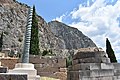
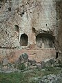
Main Archaeological site[edit]
Coordinates of the Entrance:
| Object location | | View all coordinates using: OpenStreetMap |
|---|
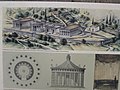
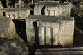
Model in the Museum[edit]


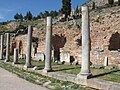
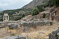
Roman Agora[edit]
| Object location | | View all coordinates using: OpenStreetMap |
|---|
Before entering the sacred precinct
-

-
-

-

-
 to temple of Apollo
 -

_on_October_4,_2020.jpg)

_05.jpg)
_03.jpg)

_on_October_4,_2020.jpg)
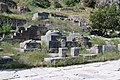
Sacred way[edit]
-

-
 Monument of the Kings of Argos
 -
 1918
1918 -
 Treasuries of the Sicyonians and Siphnians
 -
 Treasury of the Boeotians
 -
 Omphalos
 -
 Treasury of the Athenians
 -
 Bouleuterion

_on_October_4,_2020.jpg)

_on_October_4,_2020.jpg)


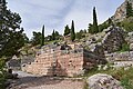
Treasury of the Sicyonians[edit]
| Object location | | View all coordinates using: OpenStreetMap |
|---|
Circa 560 BC


Treasury of the Siphnians[edit]
| Object location | | View all coordinates using: OpenStreetMap |
|---|
525 BC. See Reliefs from the Treasury of the Siphnians in the Archaeological museum of Delphi


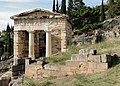
Treasury of the Athenians[edit]
| Object location | | View all coordinates using: OpenStreetMap |
|---|
507 BC. Metopes and inscriptions see Treasury of the Athenians in the Archaeological museum of Delphi


Sacred way continues[edit]
-

-

-

-
 Stoa of the Athenians
 -

-
-
-
 Looking back
.jpg)


Rock of Sibyl[edit]
| Object location | | View all coordinates using: OpenStreetMap |
|---|
Rock of Sibyl and Rock of Leto
-
 1998
1998 -
 2000
2000 -
 2004
2004 -
 2006
2006 -
 2020
2020


Sphinx of the Naxians[edit]
570-560 BC (or 570-530 BC). Place, the Sphinx see Sphinx of the Naxians in the Archaeological museum of Delphi
-
 Near polygonal mansory (548-513 BC)
 -
 Place of the Sphinx
 -

-


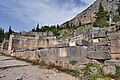
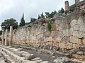
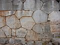
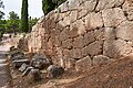
Polygonal retaining wall[edit]
Polygonal mansory under the terrace with the temple of Apollo, 548-513 BC
-
 Polygonal mansory under the temple of Apollo
 -
 Polygonal mansory and Stoa of Athenians
 -
-

-

-
-
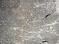
 Inscriptions
 -
-

.jpg)

.jpg)


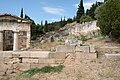
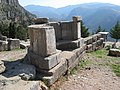
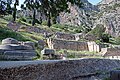
Altar[edit]
| Object location | | View all coordinates using: OpenStreetMap |
|---|
4th century BC
-

-
 Altar of Chios
 -
-
 Inscription
 -

-


_on_4_October_2020.jpg)
_on_October_4,_2020.jpg)
Serpent Column[edit]
| Object location | | View all coordinates using: OpenStreetMap |
|---|
Part of the Tripod of Plataea, after 479 BC. Replica.
-

-
 Replica in Delphi
 -
 Original base is left
 -
-
 In Istanbul (Constantinople)
 -
 Istanbul Archaelogical Museum
 -


Tripods of the Deinomenid[edit]
| Object location | | View all coordinates using: OpenStreetMap |
|---|
-
-

-

-
 Inscription


Offering of Krateros[edit]
| Object location | | View all coordinates using: OpenStreetMap |
|---|
4th century BC
-

-
 Inscription
 -

-

-

_at_the_Sanctuary_of_Delphi_on_October_4,_2020.jpg)

.jpg)

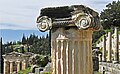
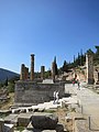
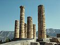
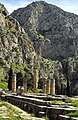
Temple of Apollo[edit]
Sculptures from this temple in the Archaeological Museum of Delphi see User:Zde/AM_of_Delphi#Room_VI
East portico[edit]
-
 On the right is Pillar of Prusias II
 -

-

-

-
-
-

-

-


.jpg)
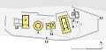
Floor plan[edit]
Coordinates of the adyton:
| Object location | | View all coordinates using: OpenStreetMap |
|---|


.jpg)


Under the adyton[edit]


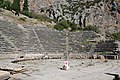
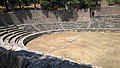
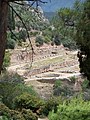
Theatre[edit]
-
 Retaining wall
 -

-

-

-

-

-
-

-

-

-

-
-

-

-

-

_on_October_4,_2020.jpg)


.jpg)


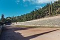
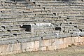
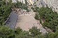
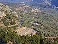
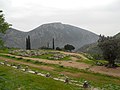
Stadium[edit]
Stadium of the Pythian games, at the upper end of the area, 5th century BC - 2nd century AD
-

-
 Retaining wall
 -
-
 Finish
 -

-
-

-
 View from the finish to the start
 -
 Start
Start -

-
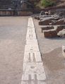 starting line
 -
 View from the path to the Fedriades
 -


.jpg)

.jpg)

.jpg)
.jpg)


Other objects[edit]
-
 Treasury of Thebes
 -
 Treasury of Poteidaea
 -
 The Stoa of the Athenians
 -

-
 Pillar of Prusias II
 -
 Daochos votive monument
 -
 Exedra of the epigones
 -
 Ex voto di Lissandro
.jpg)


Treasury of Thebes:
| Object location | | View all coordinates using: OpenStreetMap |
|---|
Treasury of the Boeotians:
| Object location | | View all coordinates using: OpenStreetMap |
|---|
Treasury of Poteidaea:
| Object location | | View all coordinates using: OpenStreetMap |
|---|
Bouleuterion:
| Object location | | View all coordinates using: OpenStreetMap |
|---|
Treasury of the Cnideans (Knidians):
| Object location | | View all coordinates using: OpenStreetMap |
|---|
Monument of the Kings of Argos:
| Object location | | View all coordinates using: OpenStreetMap |
|---|
Stoa of the Athenians, 478 BC:
| Object location | | View all coordinates using: OpenStreetMap |
|---|
Pillar of Prusias II, 3rd century BC:
| Object location | | View all coordinates using: OpenStreetMap |
|---|
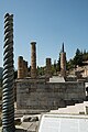
Akanthos column (with the Dencers og Delphi):
| Object location | | View all coordinates using: OpenStreetMap |
|---|
Daochos votive monument:
| Object location | | View all coordinates using: OpenStreetMap |
|---|
Castalian spring[edit]
| Object location | | View all coordinates using: OpenStreetMap |
|---|
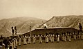
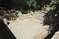
Archaic fountain[edit]
-
 1824
1824 -
-
-
-


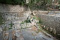
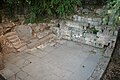
Roman fountain[edit]
Now inaccessible
-

-
-

-
 1816
1816 -
 1827
1827 -
 1833
1833 -

-
-


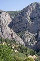
Phaedriades[edit]
Relative elevation up to 700 m
-
 1893
1893 -
-
-

-

-

_p073_DELPHI.jpg)


Down Archaeological site[edit]
Coordinates of the Entrance:
| Object location | | View all coordinates using: OpenStreetMap |
|---|
So called Marmara
-
 View from the path from Fedryades.

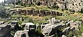
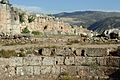
Southeastern part[edit]
-

-

-
-
 Doric treasury
 -

-
 View from the southeast
 -
 View from the south


Archaic Temple of Athena[edit]
| Object location | | View all coordinates using: OpenStreetMap |
|---|
7th and 6th century BC
-

-

-

-
 1905
1905 -

-

-
 500 BC
 -
 Finds from an even earlier time


.jpg)


Doric treasury[edit]
Classical
| Object location | | View all coordinates using: OpenStreetMap |
|---|


Treasury of the Massalians[edit]
Archaic
| Object location | | View all coordinates using: OpenStreetMap |
|---|


Tholos[edit]
| Object location | | View all coordinates using: OpenStreetMap |
|---|
380-370 BC


.jpg)


Newer Temple of Athena[edit]
| Object location | | View all coordinates using: OpenStreetMap |
|---|


Western part[edit]
-
 From the maim road

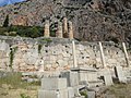
Gymnasium[edit]
330 BC and Roman times
-

-
-
-
 Palaestra and bath
 -
 Xystus and paradromis
 -
 Retaining wall
.jpg)
.jpg)


.jpg)
